Master’s Degree in Satellite Intelligence Applications in Naval Security

Why this master’s programme?

The Master’s in Satellite Intelligence Applications in Naval Security

This program provides you with the skills and knowledge to lead the digital transformation in the maritime sector. Learn to analyze geospatial data, implement advanced surveillance and monitoring systems, and optimize naval resource and operations management. Master the latest remote sensing, image processing, and machine learning technologies applied to maritime security.

This program provides you with the skills and knowledge to lead the digital transformation in the maritime sector. Learn to analyze geospatial data, implement advanced surveillance and monitoring systems, and optimize naval resource and operations management.

Differential Advantages

  • Real-world case studies: maritime incident analysis, detection of illegal activities, and crisis management.
  • Specialized software: GIS platform management, satellite data analysis tools, and simulation.
  • Professional networking: contact with industry experts, leading companies, and government agencies.
  • Multidisciplinary approach: combines knowledge of engineering, data science, maritime law, and security.
  • Flexibility: online format with the option of in-person internships and research projects.
Aplicaciones

Master’s Degree in Satellite Intelligence Applications in Naval Security

Availability: 1 in stock

Who is it aimed at?

  • Navy, Coast Guard, and Merchant Marine officers interested in optimizing maritime surveillance, early threat detection, and emergency response.
  • Intelligence and security analysts seeking to specialize in interpreting satellite data for crime prevention and critical infrastructure protection.
  • Engineers and data scientists wishing to apply their knowledge to the development of innovative solutions for naval security based on satellite technology.
  • Consultants and advisors needing to offer specialized services in satellite intelligence for the maritime and defense sectors.
  • Graduates in engineering, science, or security aspiring to a high-impact career in naval security using satellite technology Cutting edge.

Flexibility and applicability
 Adapted to the needs of working professionals: online format with live and recorded classes, practical case studies with real data, and networking with industry experts.

Aplicaciones

Objectives and skills

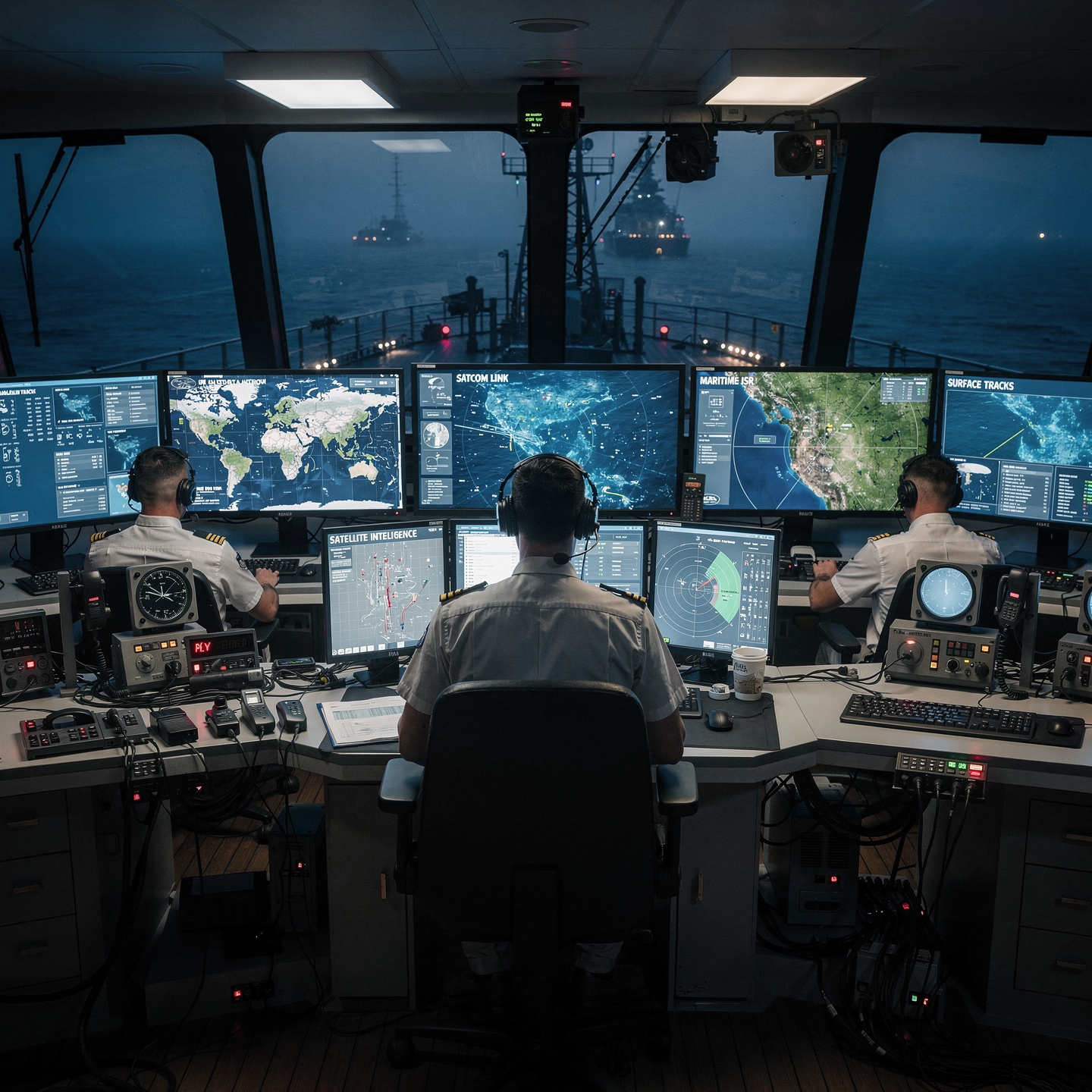
Manage maritime surveillance operations:

Integrate information from multiple sources (radar, AIS, cameras, communications) to create an accurate situational picture and act accordingly.

Accurately assess maritime threats:

Integrate AIS/Radar information, interpret meteorological data, and assess cargo/vessel vulnerabilities to anticipate risks and proactively mitigate them.

Optimizing naval strategic decision-making:

“Anticipate threats and vulnerabilities, assess risks and opportunities, and select the optimal course of action, considering naval doctrine, available intelligence, and our own and the adversary’s capabilities.”

Develop predictive models of maritime behavior:

Integrate AIS, meteorological, and historical data to predict traffic patterns, identify anomalies, and optimize routes, effectively communicating predictions to users.

Implement early warning systems for maritime incidents:

Integrate AIS, meteorological and positional data, proactively assessing risks and communicating findings to the relevant authorities.

Integrating satellite data to improve maritime navigation:

Use ocean current and wave height information derived from satellite data to optimize routes and reduce fuel consumption, while considering cargo safety and crew comfort.

Study plan – Modules

  1. Fundamentals of satellite sensors: types, physical principles, and architectures applied to maritime surveillance
  2. Radiometry and advanced spectrometry: calculation and correction of reflectances for different spectral ranges (visible, infrared, microwave)
  3. Digital image processing: filtering, segmentation, edge detection, and supervised classification for naval analysis
  4. Multisensor data fusion algorithms: integration of optical images, SAR radar, and hyperspectral sensors to improve threat detection
  5. Automatic target detection and tracking models in satellite imagery: techniques based on machine learning and convolutional neural networks (CNNs)
  6. Geometric correction and georeferencing of images for spatial accuracy in naval mapping and patrol applications
  7. Multiscale temporal analysis: detection of changes in the maritime environment for Identification of suspicious activities and monitoring of protected areas

    Advanced interpretation of radiometric signatures for discrimination between vessels, platforms, and illicit floating objects

    Optimization of early warning systems based on satellite intelligence for coastal and high seas protection

    Practical applications and case studies: integration of satellite imagery into naval command and control systems, operational exercises, and real-time simulations

  1. Fundamentals of satellite remote sensing: physical principles, passive and active sensors, spectral bands, and spatial resolution
  2. Satellite platforms for naval applications: description and technical analysis of SAR, optical, hyperspectral, and multispectral satellites
  3. Satellite image processing: radiometric and geometric correction algorithms, filtering, multispectral data fusion, and preprocessing for AI
  4. Multisensor data integration: data fusion techniques for combining SAR, optical, AIS, and meteorological information in a naval operational environment
  5. Artificial intelligence architectures applied to maritime surveillance: convolutional neural networks (CNNs), deep learning, and supervised/unsupervised methods
  6. Design and development of automatic threat detection models: identification of illegal vessels, recognition of suspicious patterns, and classification of anomalous activities
  7. Implementation of early warning systems: temporal and spatial correlation algorithms to anticipate risks and optimize tactical responses
  8. Autonomous response systems: integration with naval platforms and UAVs for coordinated, real-time actions
  9. Performance evaluation and validation of AI models: accuracy metrics, false positive rate, robustness under adverse conditions, and practical examples in real-world environments
  10. Cybersecurity considerations in the management of satellite data and AI algorithms: protection, authentication, and operational resilience against cyberattacks
  11. Regulatory and ethical aspects in the use of satellite intelligence and AI for naval security: compliance with international frameworks and responsible use protocols
  12. Advanced case studies: detailed analysis of successful naval operations that incorporated satellite detection and AI to neutralize threats in coastal areas and on the high seas
  13. Future trends and technological development: evolution of sensors Satellites, explainable AI, and multinational collaboration for integrated maritime intelligence
  1. Fundamentals of satellite image processing: sensor types, spatial, spectral, radiometric, and temporal resolution
  2. Advanced preprocessing: radiometric correction, atmospheric correction, georeferencing, and orthorectification
  3. Image segmentation and classification: supervised and unsupervised techniques applied to maritime scenarios
  4. Detection and tracking of objects in water: algorithms for identifying vessels, critical infrastructure, and potential threats
  5. Multisensor integration: fusion of optical, infrared, and radar data for high-precision naval surveillance
  6. Temporal analysis and change detection: dynamic monitoring of maritime zones and detection of anomalous activities
  7. Application of artificial intelligence and machine learning in satellite processing for naval security
  8. Predictive models and early warning systems based on satellite data for risk prevention Maritime operations
  9. Interoperability and standards in the management of geospatial data for naval security operations
  10. Case studies and real-world simulations: use of satellite imagery for maritime surveillance, patrol, and border protection missions
  1. Fundamentals of satellite sensors for naval security: principles of SAR acquisition and multispectral sensors, types and technical specifications
  2. Advanced SAR image processing: radiometric calibration techniques, geometric correction, and speckle filtering
  3. Multispectral interpretation and spectral analysis for the identification and classification of naval objects
  4. Fusion of AIS and satellite sensor data: integration, temporal and spatial synchronization for real-time maritime surveillance
  5. Maritime surveillance system architectures based on satellite intelligence: design, communication protocols, and data management
  6. Development and application of artificial intelligence algorithms for automatic detection of threats and behavioral patterns in the maritime environment
  7. Predictive models and early warning systems: implementation of machine learning to anticipate incidents and optimize operational responses
  8. Validation and verification protocols for results in satellite intelligence
  9. Operational for strategic decision-making

    Case studies and simulations of joint operations: analysis of real-world naval security scenarios using satellite intelligence platforms

    Legal and ethical aspects of using satellite intelligence for maritime security operations: respect for sovereignty, privacy, and international regulations

  1. Fundamentals of satellite intelligence applied to naval security: types of satellites, sensors, and orbital platforms
  2. Multi-source integration of satellite data: SAR radar, optical, thermal, and real-time hyperspectral imaging
  3. Advanced signal processing and data fusion algorithms for improved maritime detection and reconnaissance
  4. Development and application of AI-based predictive models to anticipate threats and hostile behavior in maritime zones
  5. Supervised and unsupervised machine learning techniques for pattern analysis in naval traffic and illicit activities
  6. Implementation of neural networks and deep learning models for automatic object classification and anomaly detection in maritime environments
  7. Dynamic simulation and modeling of tactical scenarios using artificial intelligence to optimize naval defense resource allocation
  8. Software platforms and GIS tools integrated with satellite systems for real-time maritime monitoring and surveillance.

    Cybersecurity and digital resilience protocols for handling critical satellite data to prevent interference and sabotage.

    Practical case studies in combined naval operations: interception, search and rescue, strategic reconnaissance, and maritime border control.

  1. Fundamentals of satellite imagery: physical and spectral principles of SAR and multispectral sensors
  2. SAR data processing: filtering techniques, radiometric calibration, and geometric correction for obtaining accurate images
  3. Advanced SAR interpretation algorithms: pattern identification, target detection in adverse weather conditions, and speckle noise reduction
  4. Characteristics and applications of multispectral sensors: spectral bands, vegetation indices, anomaly detection, and coastal environmental monitoring
  5. Multisensor data fusion methodologies: integrating SAR, optical, and multispectral information for greater detection accuracy
  6. Parallel processing and the use of artificial intelligence in the automated analysis of satellite images for early threat identification
  7. Detection and tracking of naval units and unauthorized vessels using classification and segmentation techniques
  8. images
  9. Practical application of early warning systems based on satellite data for rapid response in naval security scenarios

    Operational case studies: analysis of missions where combined satellite intelligence optimized naval security surveillance and maneuvers

    Development of satellite image integration protocols in naval command and control centers for real-time strategic decision-making

  1. Fundamentals of satellite technologies applied to naval security: types of satellites, geostationary and polar orbits, critical satellite communication systems for maritime operations
  2. Remote sensing systems: electromagnetic spectra, optical sensors, infrared, synthetic aperture radar (SAR), and their integration into naval platforms
  3. Advanced satellite data processing: calibration, atmospheric correction, georeferencing, and multisensor fusion to improve accuracy and real-time information provision
  4. Artificial intelligence (AI) algorithms applied to maritime surveillance: supervised and unsupervised machine learning, convolutional neural networks for automatic detection and classification of objects in satellite images
  5. Early detection of maritime threats and anomalies: application of predictive vessel behavior models, analysis of movement patterns, and exploitation of combined AIS data with satellite signals
  6. Integration of Big Data and advanced analytics for decision-making in operational scenarios: information systems architecture, early warning systems, and dashboards in naval command centers.

    Secure communication protocols and encryption in satellite transmission to protect the integrity and confidentiality of critical information in security operations.

    Implementation of autonomous and unmanned systems based on satellite information and AI algorithms for reconnaissance, surveillance, and rapid response in hostile naval environments.

    Real-world case studies and operational simulations: from coastal surveillance to interdiction on the high seas, analyzing the effectiveness of integrated technologies in complex scenarios.

    Regulatory, ethical, and cybersecurity aspects associated with satellite exploitation and artificial intelligence in naval applications, ensuring regulatory compliance and resilience against digital threats.

  1. Fundamentals of satellite intelligence applied to naval security: principles and capabilities of remote sensors
  2. Advanced satellite image processing: classification techniques, multispectral fusion, and temporal analysis for threat detection
  3. Integration of data sources: GIS, AIS, maritime radar, and passive sensors for a real-time tactical-operational view
  4. Predictive models and geospatial analysis for naval operational planning: risk assessment and dynamic scenarios
  5. Continuous maritime surveillance using SAR satellites and optical instruments: strategies for the identification and tracking of suspicious vessels
  6. Application of artificial intelligence and machine learning algorithms in the automation of naval target recognition and classification
  7. Planning naval security and defense missions based on satellite data: design, execution, and operational evaluation
  8. Optimization of routes and deployment of naval units using Satellite geointelligence analysis

    Interoperability and cybersecurity protocols in the management of critical satellite information
    Operational case studies: implementation of satellite intelligence in real-world maritime defense and incident response scenarios

  1. Fundamentals of satellite sensors: types, design, and technical-operational characteristics for maritime surveillance
  2. Digital processing of satellite signals: advanced algorithms for noise reduction, resolution enhancement, and extraction of critical data
  3. Multisensor fusion: integration of optical, SAR radar, infrared, and hyperspectral data for generating naval intelligence products
  4. Predictive models based on artificial intelligence for early detection of naval threats and maritime traffic anomalies
  5. Platforms and system architectures for real-time processing: edge computing and cloud computing in maritime security
  6. International protocols and standards for satellite data interoperability in joint naval operations
  7. Analysis and mitigation of vulnerabilities: interference, masking, and electronic countermeasures in satellite sensors
  8. Advanced visualization and systems of Early warning: GIS tools and dashboards for strategic decision-making

    Case studies: practical application in real naval operations for rapid response to asymmetric threats and illicit activities

    Trends and future technologies: evolution of satellite sensors, machine learning, and low-Earth orbit satellite networks in maritime security

  1. Project Definition and Scope: Strategic Objectives and Design Parameters for a Comprehensive Satellite Intelligence System for Naval Security
  2. Advanced Technical Architecture: Integration of Multispectral Satellite Sensors, SAR, Satellite AIS, and Real-Time Satellite Communication Systems
  3. Satellite Data Processing: Big Data Techniques, Machine Learning Algorithms, and Neural Networks for Maritime Threat Detection and Prediction
  4. Threat Scenario Modeling and Simulation: Predictive Analysis for Piracy, Illicit Trafficking, Territorial Intrusion, and Extreme Weather Conditions
  5. Geointelligence Platform Design: Development of Customized Dashboards, Real-Time Alerts, and 3D Visualization Systems for Monitoring and Rapid Response
  6. Integration with Naval Command and Control Systems: Interoperability Protocols, Military Standards, and Applied Cybersecurity
  7. Operations Management and Response: Dynamic planning based on satellite intelligence, risk assessment, and automated decision-making.

    Validation and field testing: Methodology for performance evaluation, sensor calibration, and operational effectiveness analysis.

    Legal and ethical implications: Compliance with international regulations, data protection, and maritime sovereignty in the use of satellite intelligence.

    Preparation of the final report and executive presentation: Technical documentation, operational results, and strategic recommendations for implementation in naval forces.

Career prospects

“`html

  • Naval Intelligence Analyst: Processing and analysis of satellite data for the detection and tracking of maritime threats.
  • Naval Operations Officer: Integration of satellite intelligence into the planning and execution of naval operations.
  • Maritime Security Specialist: Development and implementation of security strategies based on satellite data.
  • Satellite Intelligence Consultant: Advising companies and organizations on the use of satellite intelligence for naval security.
  • Maritime Security Researcher: Development of new technologies and methods for naval security using satellite intelligence.
  • Maritime Risk Analyst: Assessment of risks and vulnerabilities in maritime environments using satellite data.
  • Satellite Security Project Manager: Planning and management of projects related to naval security and satellite intelligence.
  • Space Agency Liaison Officer: Collaboration with space agencies for access to and use of satellite data for naval security.

“`

Entry requirements

Academic/professional profile:

Bachelor’s degree in Nautical Science/Maritime Transport, Naval/Marine Engineering or a related qualification; or proven professional experience on the bridge/in operations.

Language proficiency:

Functional Maritime English (SMCP) recommended for simulations and technical materials.

Documentation:

Updated CV, copy of qualification or seaman’s book, national ID/passport, motivation letter.

Technical requirements (for online):

Device with camera/microphone, stable internet connection, monitor ≥ 24” recommended for ECDIS/Radar-ARPA.

Admissions process and dates

Online
application

(form + documents).

Academic review and interview

Admissions decision

Admissions decision

(+ scholarship offer if applicable).

Place reservation

(deposit) and enrolment.

Induction

(access to the virtual campus, calendars, simulator guides).

Scholarships and financial support

  • Strategic Domain: Learn to interpret and apply satellite data for maritime and coastal security.
  • Cutting-Edge Technology: Delve into the use of remote sensing, geospatial analysis, and artificial intelligence applied to the naval environment.
  • Risk Analysis: Develop skills for early threat detection, monitoring of illicit activities, and crisis management in the maritime domain.
  • Simulation and Case Studies: Experiment with real-world scenarios and use simulation tools for informed decision-making.
  • Industry Experts: Receive training from professionals with extensive experience in naval security, satellite intelligence, and operations management. maritime.
Get ready to lead innovation in naval security with satellite intelligence.

Testimonials

Frequently asked questions

It focuses on military applications, specifically naval security.

Yes. The itinerary includes ECDIS/Radar-ARPA/BRM with harbor, ocean, fog, storm, and SAR scenarios.

Online with live sessions; hybrid option for simulator/practical placements through agreements.

Recommended functional SMCP. We offer support materials for standard phraseology.

Yes, with a relevant degree or experience in maritime/port operations. The admissions interview will confirm suitability.

Optional (3–6 months) through Companies & Collaborations and the Alumni Network.

Simulator practice (rubrics), defeat plans, SOPs, checklists, micro-tests and applied TFM.

A degree from Navalis Magna University + operational portfolio (tracks, SOPs, reports and KPIs) useful for audits and employment.

  1. Project Definition and Scope: Strategic Objectives and Design Parameters for a Comprehensive Satellite Intelligence System for Naval Security
  2. Advanced Technical Architecture: Integration of Multispectral Satellite Sensors, SAR, Satellite AIS, and Real-Time Satellite Communication Systems
  3. Satellite Data Processing: Big Data Techniques, Machine Learning Algorithms, and Neural Networks for Maritime Threat Detection and Prediction
  4. Threat Scenario Modeling and Simulation: Predictive Analysis for Piracy, Illicit Trafficking, Territorial Intrusion, and Extreme Weather Conditions
  5. Geointelligence Platform Design: Development of Customized Dashboards, Real-Time Alerts, and 3D Visualization Systems for Monitoring and Rapid Response
  6. Integration with Naval Command and Control Systems: Interoperability Protocols, Military Standards, and Applied Cybersecurity
  7. Operations Management and Response: Dynamic planning based on satellite intelligence, risk assessment, and automated decision-making.

    Validation and field testing: Methodology for performance evaluation, sensor calibration, and operational effectiveness analysis.

    Legal and ethical implications: Compliance with international regulations, data protection, and maritime sovereignty in the use of satellite intelligence.

    Preparation of the final report and executive presentation: Technical documentation, operational results, and strategic recommendations for implementation in naval forces.

Request information

  1. Complete the Application Form.

  2. Attach your CV/degree certificate (if you have it to hand).

  3. Indicate your preferred cohort (January/May/September) and whether you would like the hybrid option with simulator sessions.

    An academic advisor will contact you within 24–48 hours to guide you through the admission process, scholarships, and compatibility with your professional schedule.

Please enable JavaScript in your browser to complete this form.
Click or drag a file to this area to upload.

Faculty

0
    0
    Tu carrito
    Tu carrito esta vacíoRegresar a la tienda
    Scroll to Top