Marine Monitoring Technologies Course
Why this course?
The Marine Monitoring Technologies
course offers an in-depth dive into the most advanced tools and techniques for ocean observation and analysis. You will learn to master everything from remote sensors and aquatic drones to ocean simulation models and big data analysis. This program will provide you with the skills necessary to contribute to marine research, ecosystem conservation, and sustainable resource management.
Differential Advantages
- Practical Applications: analysis of real-world cases in water quality monitoring, marine species tracking, and pollution detection.
- Cutting-Edge Tools: use of specialized software for satellite image processing, oceanographic modeling, and geospatial analysis.
- Subject Matter Experts: instruction by leading professionals in the fields of oceanography, marine engineering, and environmental management.
- Multidisciplinary Approach: integration of knowledge from marine biology, ocean physics, environmental chemistry, and engineering. systems.
- Professional Networking: opportunities to connect with researchers, companies, and organizations dedicated to marine conservation.
Who is it aimed at?
- Marine biologists and oceanographers interested in analyzing environmental data, understanding the impact of human activities, and modeling ecosystems.
- Environmental and coastal engineers seeking to optimize the design and operation of marine infrastructure, manage water quality, and assess risks.
- Natural resource managers and coastal zone administrators requiring tools for decision-making, biodiversity monitoring, and sustainable planning.
- Companies in the energy and fishing sectors wishing to implement responsible practices, comply with environmental regulations, and optimize the efficiency of their operations.
- Students and recent graduates in marine and related sciences seeking to acquire practical skills in using cutting-edge technologies for the Marine monitoring.
Flexibility and applicability
Adapted for professionals and students: online modules at your own pace, real-world case studies, and direct application in research and management projects.
Objectives and competencies

Interpreting and analyzing oceanographic data:
Identify patterns, anomalies, and trends in temperature, salinity, currents, and sea level data to understand ocean dynamics and their impact on the marine environment.

Implement and maintain marine monitoring systems:
“Configure early warnings based on critical thresholds (temperature, salinity, currents) and ensure sensor redundancy for continuous coverage.”

Assess and manage marine environmental impact:
“Identify, assess and mitigate pollution from hydrocarbons and other harmful substances, implementing contingency plans and complying with MARPOL regulations.”

Develop and implement safety protocols in marine operations:
“Establish clear and concise communication procedures between all crew members and with external entities (e.g., coast guard, other vessels), using standardized terminology and redundant communication channels.”

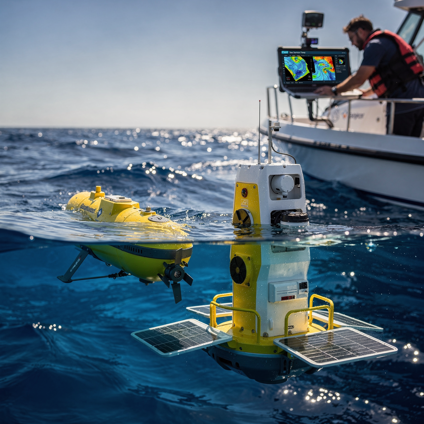
Utilizing cutting-edge technologies for marine research:
“Integrate and analyze remote sensing data (satellites, drones) and oceanographic models to optimize research and sampling routes.”

Diagnosing and resolving technical problems in marine monitoring equipment:
“Identify hardware and software failures, perform tests and adjustments, and restore operability following manuals and protocols.”
Curriculum - Modules
1.1. Types of monitoring systems: coastal, offshore, port, aquaculture, and protected areas
1.2. Definition of objectives and requirements: variables, spatial/temporal resolution, depth, and extreme conditions
1.3. Observation network design: measurement points, redundancies, representativeness, and coverage by scenario
1.4. Technology selection by environment: corrosion, biofouling, turbidity, waves, and operational accessibility
1.5. Risk management and continuity: criticality, contingency plans, degraded modes, and data recovery
1.6. System documentation and traceability: specifications, drawings, inventory, configuration, and logs
2.1. Oceanographic and marine meteorological buoys: structure, mooring, stability, and scheduled maintenance
2.2. Coastal stations and port infrastructure: location, protection, access, and 24/7 operation
2.3. Instrumented moorings and benthic nodes: ballast, recovery, mechanical integrity, and safety
2.4. Integration into mobile platforms: USV, ROV/AUV, and support vessels for hybrid campaigns
2.5. Interfaces and modular instrumentation: wet/dry connectors, compatibility, and change management
2.6. Installation verification: acceptance tests, initial calibration and commissioning criteria
3.1. Physical variables: temperature, salinity, water level/tide, currents, waves, and pressure/depth
3.2. Chemical variables: pH, ORP, dissolved oxygen, turbidity, nutrients, and indicator pollutants
3.3. Biological variables: chlorophyll, fluorescence, conceptual eDNA, bioindicators, and algal blooms
3.4. Optical observation: cameras, lighting, backscatter mitigation, and visibility criteria
3.5. Acoustic observation: ADCP, multibeam, side-scan and imaging sonar for detection and mapping
3.6. Sensor quality control: drift, interference, environmental compensations and cross-validation
4.1. Surface Telemetry: Radio, Mobile, Satellite, and Hybrid Links with Service Continuity
4.2. Submarine Communications: Acoustics, Tether, and Deferred Transfer Strategies by Operational Windows
4.3. Protocols and Formats: Packets, Time Synchronization, CRC, Metadata, and Data Normalization
4.4. Energy Management and Autonomy: Consumption, Duty Cycles, Batteries, Solar/Wind Charging, and Electrical Safety
4.5. Basic Industrial Cybersecurity: Access Control, Hardening, Key Management, and Event Logging
4.6. Real-time data architecture: buffering, store-and-forward, fault tolerance, and recovery
5.1. Ingestion and cleansing: filtering, outliers, gaps, physical consistency, and pipeline auditing
5.2. Time series: trends, seasonality, correlations, and regime change detection
5.3. Anomaly detection: thresholds, rules, simple models, and impact prioritization
5.4. Dashboards and reporting: KPIs, maps, alerts, severity levels, and stakeholder communication
5.5. Operations integration: intervention triggers, tickets, predictive maintenance, and escalation
5.6. Data management and governance: versioning, lineage, retention, integrity, and audit evidence
6.1. Operational Plan: Roles, SOPs, Checklists, Marine Weather Windows, and Go/No-Go Criteria
6.2. Preventive and Corrective Maintenance: Inspections, Anti-biofouling Cleaning, Replacement Parts, and Logbooks
6.3. Calibration and Periodic Verification: Standards, Recalibration, Uncertainty, and Metrological Traceability
6.4. Incident Management: Signal Loss, Power Failures, Mechanical Damage, and Safe Recovery
6.5. Compliance and Operating Permits: Restricted Areas, Coordination with Authorities, and Risk Management
6.6. Final applied project: network design, platform/sensor selection, telemetry, QA/QC and documented technical delivery
Plan de estudio - Módulos
1.1. Types of monitoring systems: coastal, offshore, port, aquaculture, and protected areas
1.2. Definition of objectives and requirements: variables, spatial/temporal resolution, depth, and extreme conditions
1.3. Observation network design: measurement points, redundancies, representativeness, and coverage by scenario
1.4. Technology selection by environment: corrosion, biofouling, turbidity, waves, and operational accessibility
1.5. Risk management and continuity: criticality, contingency plans, degraded modes, and data recovery
1.6. System documentation and traceability: specifications, drawings, inventory, configuration, and logs
2.1. Oceanographic and marine meteorological buoys: structure, mooring, stability, and scheduled maintenance
2.2. Coastal stations and port infrastructure: location, protection, access, and 24/7 operation
2.3. Instrumented moorings and benthic nodes: ballast, recovery, mechanical integrity, and safety
2.4. Integration into mobile platforms: USV, ROV/AUV, and support vessels for hybrid campaigns
2.5. Interfaces and modular instrumentation: wet/dry connectors, compatibility, and change management
2.6. Installation verification: acceptance tests, initial calibration and commissioning criteria
3.1. Physical variables: temperature, salinity, water level/tide, currents, waves, and pressure/depth
3.2. Chemical variables: pH, ORP, dissolved oxygen, turbidity, nutrients, and indicator pollutants
3.3. Biological variables: chlorophyll, fluorescence, conceptual eDNA, bioindicators, and algal blooms
3.4. Optical observation: cameras, lighting, backscatter mitigation, and visibility criteria
3.5. Acoustic observation: ADCP, multibeam, side-scan and imaging sonar for detection and mapping
3.6. Sensor quality control: drift, interference, environmental compensations and cross-validation
4.1. Surface Telemetry: Radio, Mobile, Satellite, and Hybrid Links with Service Continuity
4.2. Submarine Communications: Acoustics, Tether, and Deferred Transfer Strategies by Operational Windows
4.3. Protocols and Formats: Packets, Time Synchronization, CRC, Metadata, and Data Normalization
4.4. Energy Management and Autonomy: Consumption, Duty Cycles, Batteries, Solar/Wind Charging, and Electrical Safety
4.5. Basic Industrial Cybersecurity: Access Control, Hardening, Key Management, and Event Logging
4.6. Real-time data architecture: buffering, store-and-forward, fault tolerance, and recovery
5.1. Ingestion and cleansing: filtering, outliers, gaps, physical consistency, and pipeline auditing
5.2. Time series: trends, seasonality, correlations, and regime change detection
5.3. Anomaly detection: thresholds, rules, simple models, and impact prioritization
5.4. Dashboards and reporting: KPIs, maps, alerts, severity levels, and stakeholder communication
5.5. Operations integration: intervention triggers, tickets, predictive maintenance, and escalation
5.6. Data management and governance: versioning, lineage, retention, integrity, and audit evidence
6.1. Operational Plan: Roles, SOPs, Checklists, Marine Weather Windows, and Go/No-Go Criteria
6.2. Preventive and Corrective Maintenance: Inspections, Anti-biofouling Cleaning, Replacement Parts, and Logbooks
6.3. Calibration and Periodic Verification: Standards, Recalibration, Uncertainty, and Metrological Traceability
6.4. Incident Management: Signal Loss, Power Failures, Mechanical Damage, and Safe Recovery
6.5. Compliance and Operating Permits: Restricted Areas, Coordination with Authorities, and Risk Management
6.6. Final applied project: network design, platform/sensor selection, telemetry, QA/QC and documented technical delivery
#VALUE!
#VALUE!
#VALUE!
#VALUE!
Career opportunities
- Marine Buoy and Sensor Operation and Maintenance Technician: Deployment, calibration, repair, and data analysis.
- Oceanographic and Meteorological Data Analyst: Processing, interpretation, and modeling of information for prediction and risk management.
- Marine Environmental Consultant: Environmental impact assessment, design of monitoring plans, and regulatory compliance.
- Marine Scientific Researcher: Participation in research projects, development of new technologies, and publication of results.
- Underwater Acoustics Technician: Installation, operation, and analysis of underwater detection and communication systems.
- Marine Navigation and Positioning Systems Specialist: Configuration, maintenance, and optimization of GPS, INS, and other navigation systems.
- Marine Robotics Technician: Operation and maintenance of ROVs and AUVs and other autonomous underwater vehicles.
- Marine Data Manager: organization, storage, and access to large volumes of oceanographic and biological data.
“`
Admission requirements

Academic/professional profile:
Degree/Bachelor's degree in Nautical Science/Maritime Transport, Naval/Marine Engineering, or a related field; or proven professional experience in bridge/operations.

Language proficiency:
Recommended functional maritime English (SMCP) for simulations and technical materials.

5. Induction
Updated resume, copy of degree or seaman's book, ID card/passport, letter of motivation.

Technical requirements (for online):
Equipment with camera/microphone, stable connection, ≥ 24” monitor recommended for ECDIS/Radar-ARPA.
Admission process and dates

1. Online
application
(form + documents).

2. Academic review and interview
(profile/objectives/schedule compatibility).

3. Admission decision
(+ scholarship proposal if applicable).

4. Reservation of place
(deposit) and registration.

5. Induction
(access to campus, calendars, simulator guides).
Scholarships and grants
- Marine Sensors: Master the operation and calibration of CTDs, ADCPs, and oceanographic buoys to obtain accurate data.
- Remote Sensing: Learn to interpret satellite and drone imagery for water quality analysis and spill detection.
- Data Platforms: Manage and visualize information with GIS and oceanographic data analysis tools.
- Practical Applications: Develop monitoring projects in aquaculture, marine renewable energy, and coastal conservation.
- Regulations and Safety: Understand the standards and protocols for responsible marine monitoring and sustainable. Boost your career with the latest technologies for the management and protection of the marine environment.
Testimonials
During my training in Marine Monitoring Technologies, I developed an early warning system for detecting harmful algal blooms using satellite imagery and in-situ sensors. This system, successfully implemented in a pilot program, reduced response time to these events by 40%, minimizing the impact on local aquaculture and public health.
I applied the knowledge I gained in the Robotics and Underwater Technology course to develop an autonomous navigation system for an ROV used to inspect oil platforms. This system, based on machine vision and control algorithms, increased inspection efficiency by 30% and reduced risks for divers.
During my training in Marine Monitoring Technologies, I developed an early warning system for detecting red tides using satellite imagery and machine learning. This system, successfully tested in a real-world case study, reduced response time to the phenomenon by 40%, minimizing the impact on the local aquaculture industry.
During my training in Marine Monitoring Technologies, I developed an early warning system for detecting red tides using satellite imagery and machine learning. This system, successfully implemented in a pilot program, reduced response time to these events by 40%, minimizing the impact on the local aquaculture industry and public health.
Frequently asked questions
Understanding and protecting marine ecosystems by collecting data to inform research, conservation, and management.
Yes. The itinerary includes ECDIS/Radar-ARPA/BRM with harbor, ocean, fog, storm, and SAR scenarios.
Online with live sessions; hybrid option for simulator/practical placements through agreements.
To understand and track the state of the ocean and marine ecosystems for scientific, management, and conservation purposes.
Recommended functional SMCP. We offer support materials for standard phraseology.
Yes, with a relevant degree or experience in maritime/port operations. The admissions interview will confirm suitability.
Optional (3–6 months) through Companies & Collaborations and the Alumni Network.
Simulator practice (rubrics), defeat plans, SOPs, checklists, micro-tests and applied TFM.
A degree from Navalis Magna University + operational portfolio (tracks, SOPs, reports and KPIs) useful for audits and employment.
#VALUE!
Request information
- Complete the Application Form
- Attach your CV/Qualifications (if you have them to hand).
- Indicate your preferred cohort (January/May/September) and whether you want the hybrid option with simulator sessions.
Teachers
Eng. Tomás Riera
Full Professor
Eng. Tomás Riera
Full Professor
Eng. Sofía Marquina
Full Professor
Eng. Sofía Marquina
Full Professor
Eng. Javier Bañuls
Full Professor
Eng. Javier Bañuls
Full Professor
Dr. Nuria Llobregat
Full Professor
Dr. Nuria Llobregat
Full Professor
Dr. Pau Ferrer
Full Professor
Dr. Pau Ferrer
Full Professor
Cap. Javier Abaroa (MCA)
Full Professor
Cap. Javier Abaroa (MCA)
Full Professor