Master’s Degree in Coastal and Beach Dynamics
Why this master’s programme?
The Master’s in Coastal and Beach Dynamics
Provides comprehensive training in the management and conservation of these valuable ecosystems. You will learn to understand the natural processes that shape coastlines, from hydrodynamics and sediment transport to the effects of climate change and human activities. The program combines a solid theoretical foundation with modeling and simulation tools, data analysis, and real-world case studies, preparing you to address the challenges of sustainable coastal management.
Differential Advantages
- Multidisciplinary Approach: Integrates knowledge of engineering, oceanography, geology, and marine biology.
- Advanced Tools: Proficiency in hydrodynamic and sedimentary modeling software.
- Practical Experience: Participation in research and consulting projects.
- Climate Change Adaptation: Mitigation and adaptation strategies for sea level rise and extreme events.
- Professional Networking: Contact with experts from the public and private sectors.
- Modality: Online
- Level: Masters
- Hours: 1600 H
- Start date: 13-06-2026
Availability: 1 in stock
Who is it aimed at?
- Civil and environmental engineers seeking to specialize in coastal management and protection in the face of climate change.
- Geologists and oceanographers interested in deepening their knowledge of sedimentary processes and coastal morphodynamics.
- Environmental consultants and public administration technicians who need tools for planning and sustainable development of coastal areas.
- Researchers and academics wishing to advance the study of beach dynamics and modeling.
- Professionals in the tourism and fishing sectors concerned with the conservation of coastal ecosystems and the management of natural resources.
Academic flexibility
Adapted to professionals and students: online modality with live and recorded classes, multimedia resources and personalized tutoring.
Objectives and skills

Manage the coastline comprehensively:
“Optimize the use of planning and monitoring tools (electronic charts, AIS, radars) for navigation safety and efficiency.”

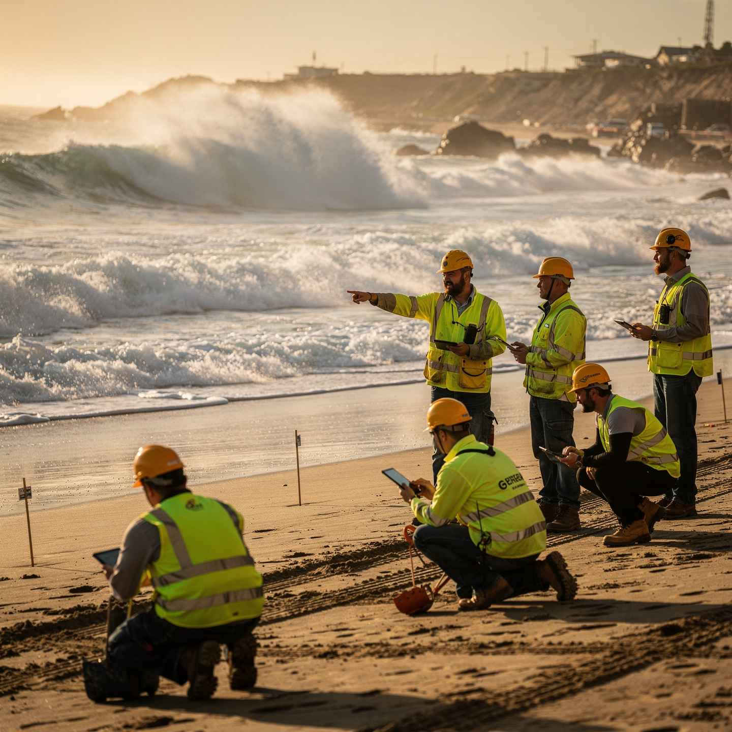
Assess and mitigate coastal risks:
Analyze the vulnerability of coastal infrastructure, develop contingency plans, and optimize the allocation of resources for prevention and response to extreme events.

Designing strategies for adapting to coastal climate change:
“Integrate green and grey infrastructure, assessing its long-term socio-economic and environmental impact.”

Modeling and predicting the evolution of coastlines:
“Using numerical models and historical data to simulate erosion, sedimentation and the impact of climate change, assessing vulnerability and proposing coastal adaptation measures.”

Develop innovative solutions for the sustainable management of beaches:
Implement AI-powered coastal monitoring systems to predict erosion and optimize resource allocation, integrating real-time oceanographic and meteorological data.

Leading research and development projects in coastal dynamics:
“Define the scope, manage resources, mitigate risks, and communicate results, ensuring scientific quality and practical applicability.”
Study plan – Modules
- Fundamentals of morphodynamic modeling: key parameters, temporal and spatial scales, and mathematical foundations
- Coastal hydrodynamic processes: waves, currents, tides, and their interaction with coastal morphology
- Advanced numerical models: principles of hydrodynamic and sedimentological modeling with application in coastal environments
- Integration of sediment transport models: analysis of the movement and redistribution of fine and coarse sediments
- Algorithms for simulating short-, medium-, and long-term morphological changes, including erosion, accretion, and dune and beach evolution
- Implementation and calibration of models using field and remote sensing data: real-time validation and adjustment techniques
- Coastal mitigation and restoration strategies: design of interventions with an integrated approach to socio-environmental systems
- Evaluation of Restoration techniques based on the natural dynamics of the coastline: use of soft and hard structures, nourishment, and bioengineering.
Planning restoration projects adapted to climate change and sea-level rise scenarios.
Methodologies for post-implementation monitoring and follow-up, including emerging technologies and early warning systems.
- Fundamentals of numerical modeling in coastal dynamics: wave equations, sediment transport, and energy balance
- Hydrodynamic and sedimentological models: implementation, calibration, and validation applied to open and closed coastal systems
- Advanced spatial and temporal discretization techniques: finite elements, finite volumes, and spectral methods
- Simulation of erosion and accumulation processes: modeling longitudinal and transverse sediment transport on beaches and dunes
- Integration of satellite and remote sensing data in the calibration of coastal numerical models
- Quantitative assessment of environmental impact using ecological and physical indicators in dynamic coastal systems
- Analysis of future climate scenarios: effects of sea-level rise and extreme events on coastal stability
- Use of geographic information systems (GIS) for the visualization and spatial analysis of simulation results
Development of protocols for decision-making based on numerical simulations: mitigation and adaptation strategies
Comprehensive case studies: practical application of advanced techniques in coastal risk identification and assessment
- Theoretical Foundations of Morphodynamic Modeling: Saint-Venant Equations, Sediment Transport Equations, and their application in coastal dynamics
- Advanced Numerical Methods: Finite Differences, Finite Volumes, Finite Elements, and the Integration of Hydrodynamic and Sedimentological Models
- Simulation of Morphodynamic Processes: Modeling of waves, coastal currents, sediment transport, and shoreline erosion under varying conditions
- Specialized Tools and Software: Practical use of models such as Delft3D, XBeach, Celeris, and Telemac for morphodynamic analysis and predictions
- Integration of Empirical and Remote Sensing Data: Incorporation of satellite imagery, LiDAR, and in-situ data for model validation and calibration
- Evaluation of Climate Change Scenarios: Impact of Sea Level Rise Sea, extreme events, and variability in sedimentary and morphological processes
Integrated coastal restoration strategies: design, optimization, and technical evaluation of sustainable environmental and engineering interventions
Nature-based solutions (NbS): restoration of dunes, coastal vegetation, artificial reefs, and their modeling for erosion mitigation
Adaptive management of beaches and coasts: planning based on predictive modeling, continuous monitoring, and strategic adjustments for coastal resilience
Advanced case studies: analysis of real-world integrated coastal restoration projects with the application of numerical modeling and environmental impact assessment
- Fundamentals of coastal sediment dynamics: processes of sediment transport, deposition, and erosion in marine and coastal environments
- Mathematical and numerical models applied to sediment dynamics: advection-diffusion equations, coupled hydrodynamic models, and sediment transport simulations
- Advanced methodologies for coastal risk assessment: vulnerability analysis, mapping of critical zones, and study of natural hazards such as storms, sea-level rise, and extreme events
- Quantitative and qualitative indicators in coastal risk assessment: statistical analysis, probability of occurrence, and severity of impacts
- Design and application of conventional coastal defenses: breakwaters, walls, groynes, and their implications for coastal dynamics and the ecosystem
- Concepts of coastal resilience and adaptation to climate change: integration of social, environmental, and economic systems in management strategies Sustainable
Nature-based solutions (NbS) for coastal defenses: dune restoration, coastal vegetation, artificial reefs, and salt marshes as natural barriers
Integration of geoenvironmental techniques and bioengineering for the protection and dynamic regulation of beaches and coasts
GIS and remote sensing tools in the spatial and temporal analysis of coastal dynamics and the planning of resilient defenses
International case studies and flagship coastal defense projects with innovative and sustainable approaches: design, implementation, and post-implementation evaluation
- Advanced principles of coastal monitoring: integration of remote sensing and in-situ techniques for continuous shoreline assessment
- Application of satellite and drone technologies in the dynamic characterization of beaches and morphodynamic changes
- Multi-scale hydrodynamic and sedimentological models: calibration, validation, and use for predicting coastal processes
- Innovation in remote sensing and photogrammetry systems for generating high-resolution topobathymetric maps
- Implementation of smart sensor networks for real-time monitoring of oceanographic and meteorological parameters
- Adaptive management strategies for coastal ecosystems based on probabilistic analyses and climate change scenarios
- Advanced GIS tools for the integration, analysis, and visualization of multidimensional coastal environmental data
- Design and use of ecosystem health indicators and Environmental services in coastal decision-making
International and local regulatory framework for sustainable coastal conservation: compliance, challenges, and opportunities
Case studies on applied science-based ecological restoration for mitigating erosion and loss of coastal habitats
Community participation and collaborative governance: innovative methodologies for integrated coastal zone management
Development of strategic plans for monitoring and sustainable coastal management: impact assessment and adaptation techniques
- Fundamentals of Coastal Dynamics: Geomorphological Processes, Sediments, and Coastal Systems
- Numerical Hydrodynamic Models: Mathematical Principles, Navier-Stokes Equations, and Discretization Methods
- Advanced Wave Simulation: Spectral Formulation, Propagation, and Transformation in the Coastal Zone
- Sediment Transport Modeling: Bedload, Suspended Load, Erosion, and Technical Deposition
- Integration of Coupled Models: Interaction between Hydrodynamics, Waves, and Coastal Morphodynamics
- Uncertainty and Sensitivity Analysis in Numerical Results: Statistical Techniques and Validation with Field Data
- Advanced Software Tools for Coastal Simulation: Delft3D, MIKE21, TELEMAC, and Their Specific Applications
- Environmental Impact Assessment (EIA): Quantitative methodologies for assessing the impact on marine and coastal ecosystems
Application of GIS in coastal spatial analysis: mapping vulnerable areas, erosion, and morphodynamic changes
Case studies of assessment and mitigation in coastal projects: beach restoration, dune protection, and sustainable management
- Fundamentals of numerical modeling in coastal systems: Navier-Stokes equations, wave theory, and sediment dynamics
- Application of advanced hydrodynamic models: wave processes, longshore drift currents, and sediment transport
- Integration of morphodynamic models for predicting short- and long-term shoreline changes
- Simulation techniques based on finite element and finite volume methods: numerical stability and convergence
- Use of geographic information systems (GIS) for spatial modeling and multiscale analysis of coastal zones
- Incorporation of climatic and anthropogenic variables into simulations to evaluate future scenarios under climate change
- Innovative sustainable management strategies: coastal zoning, ecosystem-based protection, and green infrastructure design
- Coastal resilience assessment through hydrodynamic and morphodynamic indicators combined with socioeconomic analyses
Implementation of early warning systems for extreme events: tsunamis, storms, and accelerated erosion
Case studies in advanced modeling applied to beach restoration, dune regeneration, and adaptive management of coastal regions
- Fundamentals of Geospatial Information Systems (GIS): architecture, vector and raster data models, and international standards (OGC, ISO 191xx)
- Acquisition and processing of remote data: use of multispectral satellite imagery, SAR radar, and aerial photographs for coastal analysis
- Multiscale coastal dynamics: interactions between oceanic, atmospheric, and sedimentary processes, with an emphasis on numerical modeling
- Integration of geospatial data into decision support systems for the sustainable management of beaches and coastal zones
- Spatial predictive models: advanced interpolation techniques, machine learning, and hydrodynamic simulation applied to the prediction of erosion and morphological changes
- Application of drones and in-situ sensors for topobathymetric monitoring and environmental quality assessment of coastal ecosystems
- Development of interactive geospatial tools for the temporal and spatial visualization of coastal risks and extreme events
- Multiscale assessment of coastal vulnerability and resilience through the integration of physical, biological, and socioeconomic variables
- Protocols and methodologies for generating dynamic risk maps and adaptive planning based on future climate change scenarios
- Case studies and application in open-source GIS environments and leading commercial platforms for the predictive management and mitigation of impacts on coasts and beaches
- Fundamentals of morphodynamic modeling: physical and mathematical principles applied to coastal sediment dynamics
- Advanced numerical tools: implementation and calibration of hydrodynamic and sedimentological models
- Wave dynamics, currents, and sediment transport: quantitative analysis and simulation in complex coastal environments
- Interaction between natural and anthropogenic processes: impacts and feedbacks in coastal evolution
- Integrated coastal risk assessment: probabilistic analysis of erosion, flooding, and loss of critical habitats
- Application of geographic information systems (GIS) for morphodynamic mapping and monitoring
- Predictive models for future scenarios under climate change: sea level rise, extreme storms, and climate variability
- Design and optimization of conservation strategies: innovative techniques in ecological restoration and adaptive management
- Emerging technologies in coastal monitoring: remote sensors, drones, and automated real-time measurement systems
- Case studies and applied projects in sustainable restoration: multidisciplinary integration and socio-environmental assessment
- International regulations and public policies for sustainable coastal management: sustainability criteria and integrated governance
- Methodologies for the economic and social evaluation of coastal conservation and restoration projects
- Preparation of specialized technical reports: effective communication of results to decision-makers and stakeholders
- Advanced Foundations of Coastal Dynamics: Hydrodynamic, Sedimentological, and Morphodynamic Processes in Coastal Zones
- Numerical Models Applied to Coastal Dynamics: Types, Spatial and Temporal Scales, Validation, and Calibration
- Integration of Multisensory Data: Use of Remote Sensing, LiDAR, Satellite Imagery, and In-Situ Sensors for Coastal Monitoring
- Development and Design of Predictive Management Systems: Machine Learning Algorithms, Stochastic Modeling, and Simulation of Future Scenarios
- Assessment of Coastal Resilience under Climate Change: Vulnerability Analysis, Adaptation, and Mitigation through Integrated Approaches
- Application of GIS for the Sustainable Planning and Management of Beaches and Dunes: Handling Large Geospatial Databases
- Advanced Methodologies for Coastal Risk Assessment and Mitigation: Analysis of Natural Hazards, Anthropogenic and combined factors
Participatory planning and coastal governance: strategies for social and economic inclusion in adaptive management processes
Design and development of the final project: structuring, objectives, hypotheses, methodology, and applied research protocols
Technical defense and practical application of the integrated model: presentation of results, critical discussion, and proposals for continuous improvement
Career prospects
“`html
- Coastal Engineering Consultant: Design and management of coastal protection projects, beach regeneration, and maritime works.
- Scientific Researcher: Development of numerical models and data analysis for predicting coastal evolution and the impact of climate change.
- Coastal Resource Manager: Planning and management of coastal land use, environmental impact assessment, and management of protected natural areas.
- Public Administration Technician: Advising on coastal management policies, drafting technical reports, and participating in international cooperation projects.
- Marine Renewable Energy Specialist: Evaluation of sites for the installation of offshore wind farms and other energy infrastructure.
- Hydrodynamic and Sedimentary Modeling Expert: Simulation of processes Coastal areas for the optimization of maritime works and the management of natural hazards.
- R&D&I Project Manager: development of new technologies and methodologies for coastal monitoring and management.
- Lecturer/Trainer: knowledge transfer at universities and vocational training centers in the field of coastal dynamics and beaches.
“`
Entry requirements

Academic/professional profile:
Bachelor’s degree in Nautical Science/Maritime Transport, Naval/Marine Engineering or a related qualification; or proven professional experience on the bridge/in operations.

Language proficiency:
Functional Maritime English (SMCP) recommended for simulations and technical materials.

Documentation:
Updated CV, copy of qualification or seaman’s book, national ID/passport, motivation letter.

Technical requirements (for online):
Device with camera/microphone, stable internet connection, monitor ≥ 24” recommended for ECDIS/Radar-ARPA.
Admissions process and dates

Online
application
(form + documents).

Academic review and interview
Admissions decision

Admissions decision
(+ scholarship offer if applicable).

Place reservation
(deposit) and enrolment.

Induction
(access to the virtual campus, calendars, simulator guides).
Scholarships and financial support
- Comprehensive Analysis: Master the tools for studying coastal erosion, sediment transport, and beach evolution.
- Advanced Modeling: Learn to use cutting-edge simulation software to predict coastal behavior under different scenarios.
- Sustainable Management: Acquire the skills to implement coastal protection and climate change adaptation strategies, minimizing environmental impact.
- Real-World Project: Apply your knowledge in a practical consulting or research project, working with real data and current challenges.
- Expert Networking: Connect with leading professionals in the sector, expanding your network of contacts and job opportunities. Prepare for a future in the smart and resilient management of our coasts.
Testimonials
This master’s program provided me with the tools and knowledge necessary to lead a coastal restoration project in a highly eroded area. By applying the wave and sediment transport prediction models learned in the program, we were able to stabilize the shoreline, recovering over 100 meters of beach and protecting coastal infrastructure. The project’s success has been recognized nationally and has served as a model for other similar initiatives.
During my Master’s degree in Port and Coastal Engineering, I applied the knowledge I had acquired to optimize the design of a breakwater in a port with high wave exposure, achieving a 30% reduction in internal turbulence and minimizing construction costs by 15%. These results were validated through numerical modeling and physical testing. This allowed me to obtain the highest grade on my final project and be contacted by a leading consulting firm in the sector with a job offer.
This master’s program provided me with the tools and knowledge necessary to lead a coastal restoration project in a highly eroded area. By applying the principles I learned about sediment dynamics and the design of protective structures, we were able to stabilize the coastline, recover beach areas, and protect critical infrastructure, exceeding the project’s initial expectations.
Applying the knowledge I gained from my Master’s degree in Coastal and Beach Dynamics allowed me to lead the redesign of my city’s coastal protection system, reducing erosion by 40% and recovering 100 meters of beach in the first year. The predictive modeling I learned was key to optimizing the design and ensuring its long-term sustainability.
Frequently asked questions
Coastal dynamics and beaches.
Yes. The itinerary includes ECDIS/Radar-ARPA/BRM with harbor, ocean, fog, storm, and SAR scenarios.
Online with live sessions; hybrid option for simulator/practical placements through agreements.
Recommended functional SMCP. We offer support materials for standard phraseology.
Yes, with a relevant degree or experience in maritime/port operations. The admissions interview will confirm suitability.
Optional (3–6 months) through Companies & Collaborations and the Alumni Network.
Simulator practice (rubrics), defeat plans, SOPs, checklists, micro-tests and applied TFM.
A degree from Navalis Magna University + operational portfolio (tracks, SOPs, reports and KPIs) useful for audits and employment.
- Advanced Foundations of Coastal Dynamics: Hydrodynamic, Sedimentological, and Morphodynamic Processes in Coastal Zones
- Numerical Models Applied to Coastal Dynamics: Types, Spatial and Temporal Scales, Validation, and Calibration
- Integration of Multisensory Data: Use of Remote Sensing, LiDAR, Satellite Imagery, and In-Situ Sensors for Coastal Monitoring
- Development and Design of Predictive Management Systems: Machine Learning Algorithms, Stochastic Modeling, and Simulation of Future Scenarios
- Assessment of Coastal Resilience under Climate Change: Vulnerability Analysis, Adaptation, and Mitigation through Integrated Approaches
- Application of GIS for the Sustainable Planning and Management of Beaches and Dunes: Handling Large Geospatial Databases
- Advanced Methodologies for Coastal Risk Assessment and Mitigation: Analysis of Natural Hazards, Anthropogenic and combined factors
Participatory planning and coastal governance: strategies for social and economic inclusion in adaptive management processes
Design and development of the final project: structuring, objectives, hypotheses, methodology, and applied research protocols
Technical defense and practical application of the integrated model: presentation of results, critical discussion, and proposals for continuous improvement
Request information
Complete the Application Form.
Attach your CV/degree certificate (if you have it to hand).
Indicate your preferred cohort (January/May/September) and whether you would like the hybrid option with simulator sessions.
An academic advisor will contact you within 24–48 hours to guide you through the admission process, scholarships, and compatibility with your professional schedule.
Faculty
Eng. Tomás Riera
Full Professor
Eng. Tomás Riera
Full Professor
Eng. Sofía Marquina
Full Professor
Eng. Sofía Marquina
Full Professor
Eng. Javier Bañuls
Full Professor
Eng. Javier Bañuls
Full Professor
Dr. Nuria Llobregat
Full Professor
Dr. Nuria Llobregat
Full Professor
Dr. Pau Ferrer
Full Professor
Dr. Pau Ferrer
Full Professor
Cap. Javier Abaroa (MCA)
Full Professor
Cap. Javier Abaroa (MCA)
Full Professor