Master’s Degree in Exploration of Submarine Mineral Resources

Why this master’s programme?

The Master in Subsea Mineral Resource Exploration

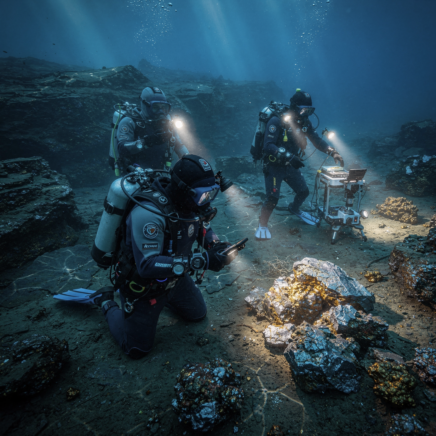
Prepares you to lead the next frontier of mining. Learn to identify, evaluate, and manage mineral deposits in deep-sea environments, from geology to sustainability. This program combines the analysis of geophysical and geochemical data, the management of subsea exploration technologies, and the study of environmental impacts, with a focus on innovation and responsibility.

Differential Advantages

  • Cutting-edge Technology: Operation of ROVs, AUVs, and remote sensors for underwater exploration.
  • Sustainable Approach: Environmental impact assessment and mitigation strategies for responsible mining.
  • Real-world Case Studies: Analysis of existing and developing underwater mining projects.
  • Industry Experts: Classes taught by leading professionals in marine resource exploration and exploitation.
  • Global Networking: Opportunities to connect with companies and research centers worldwide.
Exploración

Master’s Degree in Exploration of Submarine Mineral Resources

Availability: 1 in stock

Who is it aimed at?

  • Marine geologists and geophysicists seeking to specialize in the identification and evaluation of mineral deposits on the ocean floor.
  • Mining engineers and oceanographers wishing to acquire skills in the planning and operation of underwater mining projects.
  • Energy and materials professionals interested in resource diversification and technological innovation.
  • Researchers and academics seeking to deepen their scientific and technical knowledge related to underwater mineral resources.
  • Policymakers and regulators needing to understand the environmental and socioeconomic aspects of marine resource exploitation.

Flexibility and focus Practical

Master’s program designed for professionals and recent graduates: adaptable online methodology, relevant case studies, and networking with international experts.

Exploración

Objectives and skills

Evaluate the economic potential of underwater mineral deposits:

Analyze the feasibility of the extraction, considering costs, available technologies, environmental impact and current regulations.

Develop and apply innovative technologies for the sustainable extraction of underwater minerals:

Implement autonomous robotic systems for the selective collection of polymetallic nodules, minimizing the impact on the seabed and surrounding fauna.

Manage underwater exploration projects in compliance with environmental regulations:

Develop and implement specific environmental management plans for underwater exploration, including environmental impact assessments, risk mitigation protocols and continuous monitoring of marine biodiversity, ensuring compliance with current legislation and international standards.

To characterize underwater mineral deposits geologically and geochemically:

“Analyze the mineralogical and geochemical composition of samples using specialized techniques (XRD, ICP-MS), interpreting their origin and economic potential.”
Interpreting geophysical data to identify areas with a high probability of mineralization:

“Using specialized software and modeling techniques to analyze geophysical anomalies (gravimetric, magnetic, seismic, electrical) and correlate them with regional geological models, identifying patterns indicative of mineral deposits and prioritizing areas for further exploration.”

Modeling and simulating underwater geological processes to optimize exploration:

“Develop predictive models of sedimentation and fluid transport to identify areas of hydrocarbon accumulation and submarine mineral resources, validating them with seismic and bathymetric data.”

Study plan – Modules

  1. Fundamental Marine Geology: Structure of the oceanic crust, tectonic processes, and sedimentation in submarine environments.
  2. Advanced Geophysical Prospecting Techniques: Reflection and refraction seismics, magnetometry, gravimetry, and multifrequency sonar applied to the exploration of mineral deposits on the seabed.
  3. Interpretation of Geological and Geophysical Data: Multidisciplinary integration for the identification of mineral concentrations in mid-ocean ridges, continental margins, and abyssal basins.
  4. Geochronology and Mineralogical Analysis: Isotopic dating techniques and petrographic characterization to evaluate the composition and age of submarine mineral formations.
  5. 3D Modeling of Submarine Structures: Application of specialized software for geological reconstruction and evaluation of mineral potential.
  6. Evaluation Geological and environmental risks: seismic and volcanic hazards, and their impact on the viability of deep-sea mining.

    Advanced positioning and mapping systems: use of GNSS, underwater LiDAR, and integrated navigation systems to delineate areas of interest with centimeter-level precision.

    Satellite image processing and analysis: algorithms and techniques for the remote detection of geological anomalies indicative of mineral resources.

    Comparative studies of typical deposits: polymetallic nodules, massive sulfides, and iron-manganese crusts, their origins, and geological distribution.

    Sampling methodologies and exploration campaigns: design, planning, and execution of underwater expeditions for the collection of geological data under extreme conditions.

  1. Fundamentals of Subsea Exploration: Physical and Chemical Properties of Marine Mineral Resources
  2. Multibeam Sounding Techniques: Physical Principles, Types of Transmitters and Receivers, Frequencies, and Modes of Operation
  3. Advanced Acoustic Signal Processing: Noise Reduction, Adaptive Filtering, and Spatial Resolution Enhancement Techniques
  4. Multibeam Digital Mapping: Integration of Bathymetric Data, Geospatial Interpretation, and Three-Dimensional Seabed Modeling
  5. Methodologies for the Identification and Accurate Characterization of Mineral Deposits: Spectral Analysis, Correlation with In-Situ Samples, and Geostatistics
  6. Applications of Subsea LiDAR Systems and Comparison with Acoustic Sounding for the Improvement of High-Resolution Maps
  7. Integration of Global Positioning Systems (GPS/GLONASS/Galileo/Beidou) in the Demarcation and navigation of study areas
  8. Optimization of sampling campaigns through predictive modeling simulations and machine learning applied to multibeam data

    Calibration, validation, and quality assurance protocols for the acquisition and processing of underwater geophysical data

    International regulations and technical standards for underwater mineral exploration: reliable compliance and reporting for certification

  1. Fundamentals of marine geology: lithological classification, sedimentary processes, and submarine tectonics applied to mineral prospecting
  2. Advanced techniques of submarine geophysics: reflection and refraction seismology, magnetometry, gravimetry, and their integration for three-dimensional modeling of geological structures
  3. Multibeam mapping and high-resolution bathymetry: principles, calibration of multibeam systems, data processing, and generation of digital terrain models (DTMs)
  4. Geoscientific interpretation of multispectral and geochemical data for the identification of mineralized zones in complex submarine environments
  5. Applications of submarine LIDAR systems and acoustic sensors for the granulometric and mineralogical characterization of the seabed
  6. Integration of GIS (Geographic Information Systems) in the creation of accurate thematic maps that support Exploration and exploitation decisions
  7. Predictive models of submarine mineral deposits using artificial intelligence and machine learning with multisensor datasets

    Planning and execution of hydrographic and geophysical surveys assisted by autonomous underwater vehicles (AUVs) and remotely operated vehicles (ROVs) for efficient in-situ data acquisition

    Validation and quality control methodologies for geoscientific data to ensure reliability in investment decision-making

    Analysis of environmental and geological risks associated with mineral exploration in submarine ecosystems, complying with international regulations and best sustainable practices

    Integrative data interpretation for the precise delineation of mineralized bodies and the design of strategic sampling campaigns

    Advanced use of specialized software such as Petrel, Kingdom, and QPS for geological modeling and advanced three-dimensional visualization

    International case studies: analysis Comparison of successful projects and lessons learned in deep-sea mineral exploration

    Development of specialized technical reports for presentation to regulatory bodies and stakeholders, with emphasis on clarity, detail, and scientific evidence

    Future perspectives in geoscientific technology applied to deep-sea mining: trends, innovations, and emerging challenges

  1. Design, structure, and advanced operating systems of AUVs (Autonomous Underwater Vehicles) and ROVs (Remotely Operated Vehicles): structural integrity, hydrodynamics, and technical specifications for operations in high-pressure, low-visibility environments
  2. Planning and execution protocols for automatic and semi-automatic missions for seabed exploration and sampling, considering real-time environmental and geological parameters
  3. Implementation of inertial navigation systems, LBL (Long Baseline), USBL (Ultra-Short Baseline), and DVL (Doppler Velocity Log) sensors for precise positioning in areas of mineralogical interest
  4. Targeted sampling from AUVs/ROVs: advanced techniques for collecting sedimentological, biological, and geochemical samples, ensuring the representativeness and comprehensive preservation of the collected material
  5. Integrated instrumentation and sensors: X-ray fluorescence (XRF) spectrometers, hyperspectral cameras, multibeam sonar, and laser scanners for three-dimensional mapping of subsea deposits.

    Processing and analysis of geochemical data in situ and in the laboratory: analytical techniques for mineralogical, elemental, and isotopic characterization with emphasis on the quantification of strategic metals and trace elements.

    Preliminary environmental assessment and continuous monitoring using sensors of physical, chemical, and biological parameters to minimize the impact of exploration and ensure operational sustainability.

    Predictive models and simulators for the technical and economic evaluation of subsea mineral deposits, integrating hydrogeological, metallogenic, and market variables.

    Operational safety and risk management protocols for the deployment and recovery of AUVs/ROVs in complex and deep-sea environments, including contingencies and preventive maintenance.

    International regulations, maritime regulations, and technical standards for sustainable marine exploration and Licensing of extractive activities on the continental shelf and exclusive economic zones

  1. Advanced Fundamentals of Seismic Detection in Submarine Environments: Acquisition, Processing, and Modeling of Multibeam Data for the Accurate Identification of Mineral Deposits
  2. Emerging Technologies in Underwater Ground Penetrating Radar and Electromagnetic Sensors: Operating Principles, Limitations, and Application in Deep-Sea Exploration
  3. Multiscale Data Integration: Fusion of Geophysical, Geochemical, and Geological Information for the Generation of Robust Three-Dimensional Models
  4. Application of Artificial Intelligence and Machine Learning in the Analysis of Geological Anomalies and Prediction of Subsea Mineralized Zones
  5. Development of High-Resolution Digital Maps Using Autonomous Unmanned Vehicles (AUVs) Equipped with Advanced Sensors for In-Situ Sampling and Topographic Surveying
  6. Advanced Interpretation Methodologies for 3D Modeling: Volumetric Analysis, Resource Quantification, and Mineralogy Assessment
  7. Optimization of Exploration Workflow Using Integrated Real-Time Platforms
  8. For decision-making in subsea prospecting and drilling
  9. Numerical simulation of metallogenic processes and their impact on the delineation of priority targets for sustainable exploitation
  10. International regulations and applicable technical standards in the acquisition, processing, and reporting of subsea geological and geophysical data
  11. Professional case studies: practical application of innovative technologies in real-world projects for the exploration and modeling of subsea mineral deposits
  1. Fundamentals of underwater remote sensing: physical principles, acoustic and optical propagation in marine environments, and technical limitations for remote exploration
  2. Advanced sounding techniques: multifrequency sonar, seismic reflection and refraction profilers, and emerging technologies such as side-scan sonar and parametric sonars
  3. Implementation and calibration of multibeam systems: transducer configuration, hydrodynamic alignment, angle of incidence correction, and ambient noise compensation
  4. Acoustic data processing and analysis: filtering algorithms, echo reconstruction, spatial interpolation, and error reduction techniques in dynamic environments
  5. Detailed bathymetric mapping: generation and validation of marine digital elevation models (DEMs), integration with GIS systems, and standard formats for use in mineral exploration
  6. Applications of 3D modeling in marine geology: Structural mapping, delineation of mineral bodies, and simulations of sulfide and polymetallic deposits.

    Quantitative geophysical evaluation: interpretation of magnetic, gravimetric, and electrical conductivity anomalies as indirect indicators of mineral concentration.

    Multi-sensor integration: combining seismic, bathymetric, magnetic, and optical data for a holistic view of the deposit’s economic potential.

    Development of customized workflows for subsea exploration: from initial planning to generating technical reports for investors and regulators.

    Regulations, standards, and best practices: environmental and technological compliance, international certifications for marine surveys and mapping, and secure management of sensitive geospatial data.

    Real-world case studies: detailed analysis of successful exploration projects for polymetallic nodules, cobalt-bearing crustaceans, and massive sulfides on the seabed. Deep ocean environments

  7. Specialized software tools: advanced management of platforms such as Fledermaus, QPS Qimera, and Petrel for underwater interpretation of mineral resources

    Validation and verification techniques for results: use of autonomous underwater vehicles (AUVs) and manned submersibles for direct corroboration of geophysical data

    Operational planning for underwater campaigns: logistical aspects, equipment selection, safety protocols, and time optimization in high-pressure and deep-sea environments

    Future perspectives and technological trends: artificial intelligence for predictive analysis, machine learning applied to geological datasets, and cutting-edge technologies for non-invasive exploration

  1. Fundamentals of Advanced Subsea Exploration: physical and geological principles in deep-sea environments, sea-land interaction, and specific characteristics of subsea mineral deposits
  2. Sensor Technologies and Data Acquisition Systems: multibeam profilers, sub-bottom profilers, magnetometry, and gravimetry for the precise and non-invasive detection of resources on the seabed
  3. Autonomous and Remotely Operated Robotic Platforms (AUV/ROV): design, navigation, and application in mapping and sampling of subsea mineral deposits
  4. Geospatial Integration and Marine GIS: advanced processing techniques, 3D modeling, and spatial analysis for geological interpretation and preliminary reserve assessment
  5. Multidisciplinary Methodologies for Resource Assessment: combination of geophysical data, Geological, geochemical, and environmental factors for robust deposit characterization

    Innovations in In Situ Sampling Techniques and Core Sampling: procedures to minimize errors and preserve the original content of the evaluated minerals

    Geometallurgical Modeling and Deposit Simulation: application of predictive algorithms and specialized software for the reliable estimation of mineral volume, grade, and distribution

    Environmental Assessment and Monitoring in Subsea Mining Projects: international protocols, impact mitigation, and analysis of ecological risks associated with extraction

    Integration of Big Data and Artificial Intelligence for exploration optimization: development of intelligent models for the automatic recognition and classification of submarine geological patterns

    Case Studies and Practical Applications: detailed analysis of international subsea mining projects, their technical, logistical, and environmental challenges regulatory

  1. Fundamentals of marine geophysics applied to mineral resource exploration: principles of seismic, electromagnetic, and gravimetric waves in submarine environments
  2. Comprehensive design of exploration campaigns: target definition, selection of geophysical techniques, and logistical planning in complex oceanic contexts
  3. Implementation and operation of advanced automated sampling technologies: use of autonomous underwater vehicles (AUVs), remotely operated vehicles (ROVs), and robotic probes for the precise collection of underwater samples
  4. Processing and analysis of geophysical data in real time: advanced algorithms for structural, stratigraphic, and geochemical interpretation of marine mineral deposits
  5. Strategies for the multidisciplinary integration of geophysical, geochemical, and oceanographic data aimed at the accurate evaluation of deposits
  6. Application of dynamic navigation and positioning systems (DGNSS, USBL, LBL) for accuracy in the Underwater mapping and sampling

    Risk management and environmental considerations in the execution of marine exploration campaigns: regulations, impact mitigation, and safety protocols

    Three-dimensional modeling and predictive simulation of mineral deposits: specialized tools and software for volumetric estimation and resource quality

    Automated sampling methodologies for in-situ and post-campaign analysis: calibration, preservation, and traceability techniques for samples

    Preparation of executive technical reports integrating geophysical and geochemical results, design of thematic maps, and presentation for decision-making in the deep-sea mining industry

  1. Fundamentals of Submarine Geophysics: Principles of Seismic Propagation, Magnetometry, and Gravimetry Applied to Marine Environments
  2. Integration of Multibeam Techniques: Multibeam Sonar for High-Resolution Bathymetry and Detection of Submarine Geological Structures
  3. Advanced Processing of Geophysical Data: Filtering, Inversion, and 3D Modeling Algorithms for Delineation of Mineral Bodies
  4. Digital Submarine Mapping: GIS Systems and Spatial Modeling Applied to the Thematic Representation of Mineral Resources
  5. Application of Autonomous Underwater Vehicles (AUVs) and Remotely Operated Vehicles (ROVs) in Exploration Phases
  6. Design of Multi-Technology Exploration Campaigns for Optimizing Coverage and Accuracy in Deposit Location
  7. Detection and Characterization of Polymetallic Deposits: Integrated Geophysical Analysis for the Identification of Nodules, Massive Sulfides, and Cobalt crustaceans
  8. Methodologies for quality control and cross-validation of data acquired by autonomous sensors and remote technologies

    Submarine geometallurgical modeling: correlation between detected physical properties and mineralogical composition

    Environmental considerations and international regulations for responsible and sustainable exploration in marine protected areas

    Implementation of digital platforms for real-time monitoring and integrated management of submarine geological and geophysical data

    Design and execution of operational safety protocols during exploration campaigns with autonomous technologies

    Strategies for multidisciplinary integration: collaboration between geologists, geophysicists, oceanographic engineers, and underwater robotics specialists

    Case studies: analysis of successful submarine mineral exploration projects using integrated techniques

    Emerging technological trends: artificial intelligence applied to automatic interpretation and decision-making in exploration underwater

  1. Advanced methodologies for the integration of autonomous underwater vehicles (AUVs) and remotely operated vehicles (ROVs) in mineral exploration campaigns
  2. Sensory capabilities: multibeam sonar, acoustic cameras, magnetometers, and geochemical sensors for the in-situ detection and characterization of mineral deposits
  3. Development and implementation of autonomous navigation and obstacle avoidance algorithms in extreme and unpredictable seabed environments
  4. 3D geospatial modeling: advanced volumetric reconstruction techniques using underwater photogrammetry and LiDAR data adapted to underwater conditions
  5. Big data processing and application of artificial intelligence for the detailed interpretation of geological formations and mineral anomalies
  6. Evaluation of critical geoenvironmental parameters to ensure the sustainability of extraction, including ecosystem impact and waste management marine
  7. Integration of GIS systems specifically designed for underwater use, facilitating the overlay of technical, cartographic, and operational data in real time
  8. Workflow optimization: planning, execution, and monitoring in the exploration and evaluation phases of underwater deposits, with an emphasis on safety and efficiency
  9. Advanced protocols for the calibration, verification, and validation of sensors and digital models under extreme depth and pressure conditions
  10. Preparation of robust final technical reports that consolidate findings, operational recommendations, and environmental mitigation proposals based on rigorous scientific criteria

Career prospects

“`html

  • Exploration Geologist/Geophysicist: Planning and execution of underwater sampling and prospecting campaigns.
  • Deep-Sea Mining Engineer: Design and optimization of mineral resource extraction methods in marine environments.
  • Resource Assessment Specialist: Estimation of mineral reserves and economic feasibility analysis of deep-sea mining projects.
  • Marine Environmental Consultant: Environmental impact assessment and development of mitigation strategies for deep-sea mining.
  • Research Scientist: Development of new technologies and methodologies for the exploration and sustainable exploitation of deep-sea mineral resources.
  • Deep-Sea Mining Project Manager: Planning, coordination, and supervision of mineral resource exploration and extraction projects at sea.
  • Maritime Law Expert and mining regulations: Legal advice and regulatory compliance in the field of deep-sea mining.

    Marine Geological Risk Analyst: Identification and assessment of geological risks associated with deep-sea mining (tsunamis, landslides, etc.).

    “`

Entry requirements

Academic/professional profile:

Bachelor’s degree in Nautical Science/Maritime Transport, Naval/Marine Engineering or a related qualification; or proven professional experience on the bridge/in operations.

Language proficiency:

Functional Maritime English (SMCP) recommended for simulations and technical materials.

Documentation:

Updated CV, copy of qualification or seaman’s book, national ID/passport, motivation letter.

Technical requirements (for online):

Device with camera/microphone, stable internet connection, monitor ≥ 24” recommended for ECDIS/Radar-ARPA.

Admissions process and dates

Online
application

(form + documents).

Academic review and interview

Admissions decision

Admissions decision

(+ scholarship offer if applicable).

Place reservation

(deposit) and enrolment.

Induction

(access to the virtual campus, calendars, simulator guides).

Scholarships and financial support

  • Expert Knowledge: Master the most advanced techniques in the exploration of polymetallic nodules, massive sulfides, and ferromanganese crusts.
  • Cutting-Edge Technology: Learn to use specialized software and hardware for the detection, modeling, and evaluation of mineral resources.
  • Legal and Environmental Framework: Understand the complex international regulatory framework and best practices for environmental sustainability in deep-sea mining.
  • Case Studies: Apply your knowledge in real-world simulations and case studies, preparing you for the challenges of the sector.
  • Professional Opportunities: Access a network with leading companies and research centers in exploration and exploitation of underwater resources.
Boost your career in a booming sector with a master’s degree that will make you an expert in exploration of underwater mineral resources.

Testimonials

Frequently asked questions

Yes. The itinerary includes ECDIS/Radar-ARPA/BRM with harbor, ocean, fog, storm, and SAR scenarios.

Online with live sessions; hybrid option for simulator/practical placements through agreements.

Solid mineral resources such as polymetallic nodules, massive sulfides and ferromanganese crusts.

Recommended functional SMCP. We offer support materials for standard phraseology.

Yes, with a relevant degree or experience in maritime/port operations. The admissions interview will confirm suitability.

Optional (3–6 months) through Companies & Collaborations and the Alumni Network.

Simulator practice (rubrics), defeat plans, SOPs, checklists, micro-tests and applied TFM.

A degree from Navalis Magna University + operational portfolio (tracks, SOPs, reports and KPIs) useful for audits and employment.

  1. Advanced methodologies for the integration of autonomous underwater vehicles (AUVs) and remotely operated vehicles (ROVs) in mineral exploration campaigns
  2. Sensory capabilities: multibeam sonar, acoustic cameras, magnetometers, and geochemical sensors for the in-situ detection and characterization of mineral deposits
  3. Development and implementation of autonomous navigation and obstacle avoidance algorithms in extreme and unpredictable seabed environments
  4. 3D geospatial modeling: advanced volumetric reconstruction techniques using underwater photogrammetry and LiDAR data adapted to underwater conditions
  5. Big data processing and application of artificial intelligence for the detailed interpretation of geological formations and mineral anomalies
  6. Evaluation of critical geoenvironmental parameters to ensure the sustainability of extraction, including ecosystem impact and waste management marine
  7. Integration of GIS systems specifically designed for underwater use, facilitating the overlay of technical, cartographic, and operational data in real time
  8. Workflow optimization: planning, execution, and monitoring in the exploration and evaluation phases of underwater deposits, with an emphasis on safety and efficiency
  9. Advanced protocols for the calibration, verification, and validation of sensors and digital models under extreme depth and pressure conditions
  10. Preparation of robust final technical reports that consolidate findings, operational recommendations, and environmental mitigation proposals based on rigorous scientific criteria

Request information

  1. Complete the Application Form.

  2. Attach your CV/degree certificate (if you have it to hand).

  3. Indicate your preferred cohort (January/May/September) and whether you would like the hybrid option with simulator sessions.

    An academic advisor will contact you within 24–48 hours to guide you through the admission process, scholarships, and compatibility with your professional schedule.

Please enable JavaScript in your browser to complete this form.
Click or drag a file to this area to upload.

Faculty

0
    0
    Tu carrito
    Tu carrito esta vacíoRegresar a la tienda
    Scroll to Top