Diploma in Drones and Maritime Sensors
Why this certificate program?
The Diploma in Drones and Maritime Sensors
This program offers comprehensive training in the application of drone technologies for the inspection, monitoring, and analysis of maritime environments. Learn to capture high-quality aerial data with drones equipped with specialized sensors, and to process and interpret the information obtained for strategic decision-making. This program prepares you to lead innovation in coastal resource management, maritime safety, and oceanographic research.
Differential Advantages
- Proficiency in specialized software: Pix4Dmapper, DroneDeploy, and geospatial analysis tools.
- In-depth knowledge of marine sensors: multispectral cameras, LiDAR, water quality sensors.
- Data processing skills: orthomosaics, 3D models, satellite image analysis.
- Regulatory compliance and safety: drone legislation, risk management, operational best practices.
- Practical applications: coastal infrastructure inspection, pollution control, environmental impact studies.
- Modality: Online
- Level: Diplomado
- Hours: 800 H
- Start date: 13-06-2026
Availability: 1 in stock
Who is it aimed at?
- Maritime industry professionals looking to integrate drones for inspection, surveillance, and operations.
- Engineers and technicians interested in the application of sensors for environmental and structural monitoring in marine environments.
- Maritime service companies wanting to optimize their operations with drone technologies and accurate data.
- Researchers and academics exploring the latest trends in remote sensing and marine data analysis.
- Entrepreneurs looking to develop innovative solutions based on drones and sensors for the maritime sector.
Learning flexibility
Adapted for professionals with demanding schedules: online content available 24/7, discussion forums and personalized follow-up.
Objectives and competencies

Manage the collected geospatial information:
“Accurately and securely processing, storing, and sharing geospatial data for informed decision-making.”

Inspect and assess maritime infrastructure:
“Identify structural deterioration, assess corrosion-related risks, and propose preventive and corrective maintenance measures.”

Apply current regulations to maritime drone operations:
“Comply with maritime and air navigation regulations, including restricted areas, notifications to authorities (Coast, Maritime Captaincy) and data protection.”

Optimizing efficiency in maritime surveillance and security:
Implement dynamic and adaptable patrolling strategies, based on risk analysis and supported by cutting-edge technology (drones, radars, automatic identification systems), for early detection and effective response to threats.

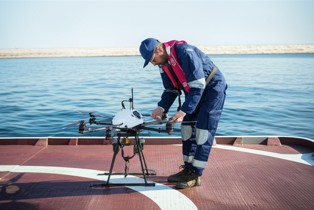
Operate and maintain drones and sensors specific to the maritime environment:
“Perform pre-flight inspections and preventive maintenance specific to saline environments, ensuring the operability and longevity of the equipment.”

Implement innovative solutions for monitoring the marine environment:
“Develop and integrate AI systems for predictive analysis of oceanographic data and early detection of environmental threats.”
Curriculum - Modules
- Comprehensive Maritime Incident Management: protocols, roles, and chain of command for coordinated response
- Operational Planning and Execution: briefing, routes, weather windows, and go/no-go criteria
- Rapid Risk Assessment: criticality matrix, scene control, and decision-making under pressure
- Operational Communication: VHF/GMDSS, standardized reports, and inter-agency liaison
- Tactical Mobility and Safe Boarding: RHIB maneuvers, approach, mooring, and recovery
- Equipment and Technologies: PPE, signaling, satellite tracking, and field data logging
- Immediate Care of the Affected: primary assessment, hypothermia, trauma, and stabilization for evacuation
- Adverse Environmental Conditions: swell, Visibility, flows, and operational mitigation
Simulation and training: critical scenarios, use of VR/AR, and exercises with performance metrics
Documentation and continuous improvement: lessons learned, indicators (MTTA/MTTR), and SOP updates
- Introduction to Maritime Drones: Types, Capabilities, and Regulations
- Sensors and Payloads: Cameras, Thermal Imaging, Multispectral, LiDAR
- Flight Planning Software: Configuration, Parameters, Exclusion Zones
- Safe Operation in Marine Environments: Wind, Waves, Corrosion, Interference
- Preventive Maintenance: Inspections, Cleaning, Lubrication, Parts Replacement
- Troubleshooting: Batteries, Motors, Propellers, Communication Systems
- Data Analysis: Image Processing, Orthomosaics, 3D Models
- Maritime Applications: Infrastructure Inspection, Surveillance, Search and Rescue
- Integration with data platforms: Storage, visualization, advanced analytics
- Ethics and privacy in drone data collection and use
‘
- Introduction to Operations: Types, Phases, and Optimization.
- Maintenance Fundamentals: Preventive, Corrective, and Predictive.
- Data Acquisition: Sensors, Telemetry, and SCADA Systems.
- Databases: Information Structure, Storage, and Management.
- Exploratory Data Analysis (EDA): Visualization, Summarization, and Outliers.
- Data Analysis Tools: Python, R, SQL.
- Performance Metrics: KPIs, SLAs, and OEE.
- Condition-Based Maintenance (CBM): Techniques and Applications.
- Predictive Modeling: Regression, classification, and time series.
- Reporting and visualizing results: Dashboards, reports, and presentations.
‘
- Introduction to Data Operation, Maintenance, and Analysis: Key Concepts and Lifecycle
- Data Collection and Storage: Sources, Formats, Databases, and Data Lakes
- IT Infrastructure: Servers, Networks, Cloud Computing, and Virtualization
- Operating Systems and Administration Tools: Linux, Windows Server, Scripting
- System Monitoring: Tools, Key Metrics, and Alerts
- Preventive and Corrective Maintenance: Procedures, Documentation, and Best Practices
- Computer Security: Data Protection, Firewalls, Antivirus, and Backups
- Exploratory Data Analysis (EDA): Visualization, Descriptive Statistics, and Pattern Identification
- Data Analysis Tools: Python, R, SQL, Pandas, Scikit-learn
Reporting and Data Visualization: dashboards, KPIs, and communicating results
‘
- Introduction to Operation and Maintenance: Key Concepts, Asset Lifecycle.
- IT Infrastructure Fundamentals: Hardware, Operating Systems, Networking, and Virtualization.
- Preventive Maintenance: Scheduling, Inspections, Lubrication, and Calibration.
- Corrective Maintenance: Troubleshooting, Repair, and Component Replacement.
- Predictive Maintenance: Monitoring Techniques, Vibration Analysis, Thermography.
- Sensors and Actuators: Types, Operation, Calibration, and Maintenance.
- Data Collection and Storage: Databases, Data Lakes, and Data Warehouses.
- Exploratory Data Analysis (EDA): Visualization, Descriptive Statistics, and Pattern Identification.
- Predictive Modeling: Machine learning algorithms for failure prediction and optimization.
Reporting and results visualization: dashboards, KPIs, and communication of findings.
‘
- System Architecture and Components: Structural design, materials, and subsystems (mechanical, electrical, electronic, and fluid) with selection and assembly criteria for marine environments
- Fundamentals and Principles of Operation: Physical and engineering foundations (thermodynamics, fluid mechanics, electricity, control, and materials) that explain performance and operating limits
- Safety and Environmental (SHE): Risk analysis, PPE, LOTO, hazardous atmospheres, spill and waste management, and emergency response plans
- Applicable Regulations and Standards: IMO/ISO/IEC requirements and local regulations;
- Conformance criteria, certification, and best practices for operation and maintenance
- Inspection, testing, and diagnostics: Visual/dimensional inspection, functional testing, data analysis, and predictive techniques (vibration, thermography, fluid analysis) to identify root causes
- Preventive and predictive maintenance: Hourly/cycle/seasonal plans, lubrication, adjustments, calibrations, consumable replacement, post-service verification, and operational reliability
- Instrumentation, tools, and metrology: Measuring and testing equipment, diagnostic software, calibration and traceability; selection criteria, safe use, and storage
- Onboard integration and interfaces: Mechanical, electrical, fluid, and data compatibility; Sealing and watertightness, EMC/EMI, corrosion protection, and interoperability testing.
Quality, acceptance testing, and commissioning: process and materials control, FAT/SAT, bench and sea trials, go/no-go criteria, and evidence documentation.
Technical documentation and integrated practice: logs, checklists, reports, and a complete case study (safety → diagnosis → intervention → verification → report) applicable to any system.
- Introduction to hyperspectral sensors: Physical principles and spectroscopy.
- Infrared thermography: Principles, equipment, and applications in various fields.
- Aerial platforms for sensors: Drones, aircraft, and satellites. Design and operational considerations.
- Calibration and correction of hyperspectral and thermographic data. Errors and mitigation methods.
- Hyperspectral image processing: Dimensionality reduction, classification, and principal component analysis.
- Thermal image analysis: Anomaly detection, temperature quantification, and thermal patterns.
- Integration of hyperspectral and thermographic data: Fusion techniques and conjoint analysis.
- Applications in precision agriculture: Crop health monitoring, water stress identification, and disease detection.
- Applications in environmental monitoring: Land cover classification, pollution detection, and water quality assessment.
- Case studies and future trends in hyperspectral sensors and onboard thermography.
‘
Career opportunities
- Marine Drone Inspection Technician: Inspection of hulls, offshore structures, and hard-to-reach areas.
- Cartography and Bathymetry Specialist: Creation of high-precision marine maps using drones and sensors.
- Oceanographic Data Manager: Collection and analysis of marine environmental data (temperature, salinity, water quality) using sensors mounted on drones.
- Marine Search and Rescue Technician: Use of drones for search and rescue, damage assessment, and logistical support.
- Marine Biology and Coastal Ecology Researcher: Monitoring of species, habitats, and ecological processes with drones equipped with multispectral cameras and other sensors.
- Marine Drone Applications Consultant: Consulting to companies and public bodies on the use of drones and sensors in the maritime sector.
- Maritime Drone Technology Developer: Design, testing, and improvement of drones, sensors, and software for specific applications at sea.
- Drone Operator in Aquaculture Companies: Crop monitoring, disease detection, and production optimization.
“`
Admission requirements

Academic/professional profile:
Degree/Bachelor's degree in Nautical Science/Maritime Transport, Naval/Marine Engineering, or a related field; or proven professional experience in bridge/operations.

Language proficiency:
Recommended functional maritime English (SMCP) for simulations and technical materials.

Documentation:
Updated resume, copy of degree or seaman's book, ID card/passport, letter of motivation.

Technical requirements (for online):
Equipment with camera/microphone, stable connection, ≥ 24” monitor recommended for ECDIS/Radar-ARPA.
Admission process and dates

1. Online
application
(form + documents).

2. Academic review and interview
(profile/objectives/schedule compatibility).

3. Admission decision
(+ scholarship proposal if applicable).

4. Reservation of place
(deposit) and registration.

5. Induction
(access to campus, calendars, simulator guides).
Scholarships and grants
- Fundamentals and Regulations: Master current legislation and drone flight principles in the maritime environment.
- Advanced Sensors: Learn to use and interpret data from multispectral, thermal imaging, and LiDAR cameras for marine applications.
- Data Processing: Acquire skills in photogrammetry and 3D modeling for coastal and maritime infrastructure analysis.
- Maritime Applications: Explore use cases in infrastructure inspection, coastal surveillance, oceanography, and resource management.
- Flight Practice: Conduct simulated and real missions to solidify your knowledge and skills in drone operation. maritime drones.
Testimonials
This diploma program exceeded my expectations. I gained solid theoretical and practical knowledge about drone operation and the use of maritime sensors, including mission planning, data processing, and results interpretation. The hands-on experience with different platforms and software has opened doors to new professional opportunities in the maritime sector.
The Diploma in Naval Technology and Innovation provided me with the tools and knowledge necessary to lead the development of a new hybrid propulsion system for small vessels. By applying the concepts I learned about energy efficiency and naval systems design, I optimized the prototype’s performance by 25%, exceeding project expectations and contributing to a more sustainable solution for the industry.
This diploma program exceeded my expectations. I acquired solid theoretical and practical knowledge about drone operation and the use of marine sensors, including mission planning, data processing, and results interpretation. The skills I learned allowed me to successfully lead a coastal monitoring project, demonstrating the efficiency of these technologies in collecting oceanographic data.
This diploma program provided me with the tools and knowledge necessary to develop a coastal monitoring system using drones and multispectral sensors. I successfully implemented a pilot project that detected and analyzed the proliferation of harmful algae in a protected coastal area, crucial information for local authorities in making decisions for ecosystem preservation.
Frequently asked questions
Drone technology and maritime sensors.
Yes. The itinerary includes ECDIS/Radar-ARPA/BRM with harbor, ocean, fog, storm, and SAR scenarios.
Online with live sessions; hybrid option for simulator/practical placements through agreements.
Maritime sector, including areas such as oceanography, hydrography, aquaculture, marine infrastructure inspection, search and rescue, and coastal surveillance.
Recommended functional SMCP. We offer support materials for standard phraseology.
Yes, with a relevant degree or experience in maritime/port operations. The admissions interview will confirm suitability.
Optional (3–6 months) through Companies & Collaborations and the Alumni Network.
Simulator practice (rubrics), defeat plans, SOPs, checklists, micro-tests and applied TFM.
A degree from Navalis Magna University + operational portfolio (tracks, SOPs, reports and KPIs) useful for audits and employment.
- Introduction to Maritime Drones: Types, Applications, and Regulations
- Aerodynamics and Stability of Drones in Marine Environments
- Onboard Sensors: Cameras (RGB, Multispectral, Hyperspectral), LiDAR, Sonar, Weather Sensors
- Communications: Radio Frequency, Satellite, and Acoustic Links in Marine Environments
- Propulsion and Power Systems: Batteries, Fuel Cells, Range, and Recharging
- Mission Planning: Areas of Interest, Environmental Conditions, and Operational Restrictions
- Safe Operation: Pre-flight, In-flight, and Post-flight Procedures at Sea
- Data Processing: Geometric Correction, Orthomosaics, and Models 3D, spectral analysis
Data analysis: object detection, classification, segmentation, and statistical modeling
Specific applications: infrastructure inspection, environmental monitoring, search and rescue, maritime surveillance‘
Request information
Complete the Application Form.
Attach your CV/degree certificate (if you have it to hand).
Indicate your preferred cohort (January/May/September) and whether you would like the hybrid option with simulator sessions.
An academic advisor will contact you within 24–48 hours to guide you through the admission process, scholarships, and compatibility with your professional schedule.
Faculty
Eng. Tomás Riera
Full Professor
Eng. Tomás Riera
Full Professor
Eng. Sofía Marquina
Full Professor
Eng. Sofía Marquina
Full Professor
Eng. Javier Bañuls
Full Professor
Eng. Javier Bañuls
Full Professor
Dr. Nuria Llobregat
Full Professor
Dr. Nuria Llobregat
Full Professor
Dr. Pau Ferrer
Full Professor
Dr. Pau Ferrer
Full Professor
Cap. Javier Abaroa (MCA)
Full Professor
Cap. Javier Abaroa (MCA)
Full Professor