Course in Historical Cartography

Why this course?

Discover the secrets of the past with our Historical Cartography course.

Learn to interpret old maps as windows to other eras, unraveling the evolution of territories, cities, and cultures. Delve into the drawing and representation techniques used by cartographers of yesteryear, and understand the social, political, and economic context that shaped each map.

Key Benefits

  • Detailed Analysis: Master the reading and interpretation of historical maps from various periods and regions.
  • Historical Context: Understand the relationship between cartography and the historical events that influenced its creation.
  • Representation Techniques: Explore the drawing, projection, and symbolism techniques used in early cartography.
  • Heritage Appreciation: Appreciate the cultural and heritage value of historical maps as unique documents.
  • Practical Applications: Use your knowledge in historical research, genealogy, heritage management, and cultural tourism.
Cartografía

Course in Historical Cartography

Availability: 1 in stock

Who is it aimed at?

  • Historians and archaeologists who wish to interpret old maps as primary sources for understanding territorial evolution and human settlements.
  • Geographers and cartographers interested in analyzing the accuracy and biases of historical cartography, as well as its influence on the perception of space.
  • Archivists and librarians responsible for the preservation and cataloging of old map collections, learning to identify relevant features.
  • Genealogical researchers who seek to trace changes in place names and geographical boundaries through historical maps to complement their research.
  • Local history enthusiasts and students who wish to delve deeper into the past of their region through the analysis of historical maps and their social and political context.

    Accessibility
    Downloadable study materials, self-paced explanatory videos, and discussion forums, compatible with any device.

Cartografía

Objectives and competencies

Interpreting old maps to understand territorial evolution:

Analyze the symbology, toponymy and cartographic details to reconstruct historical landscapes and settlement dynamics.

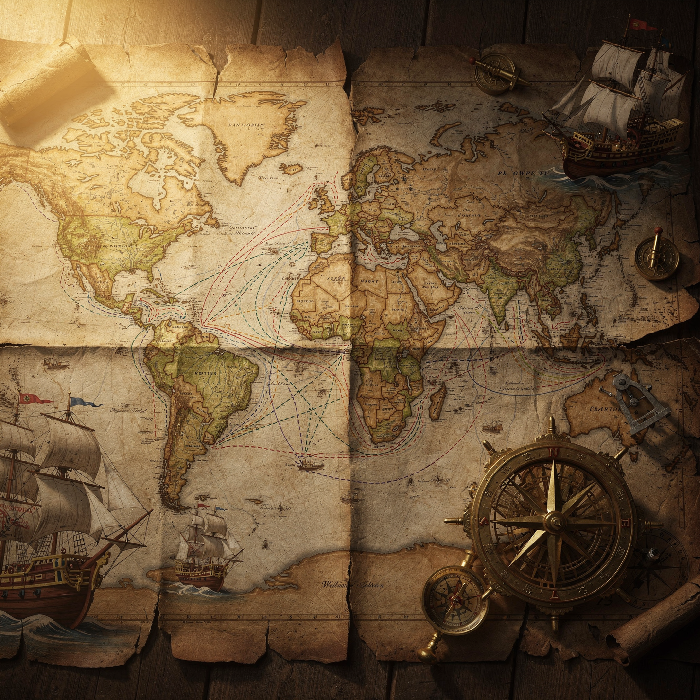
Reconstructing past trade routes and itineraries:

Analyze historical maps, cargo records, and navigation logs to identify trade patterns and flows, considering climatic and geopolitical factors that influenced their development and decline.

Locate and analyze vanished human settlements through mapping:

“Identify settlement patterns on historical maps, assess the reliability of cartographic sources, and recognize evidence of environmental or social changes that explain their disappearance.”

Understanding ancient cartographic symbology to decipher hidden information:

“Interpreting legends, compass roses, geodetic datums and projective deformations to identify nautical hazards, strategic resources and forgotten alternative routes.”

Anticipating and understanding environmental changes and historical natural disasters:

Analyze historical data and model future scenarios to identify areas of risk and vulnerability to environmental events and disasters.

Reveal military and defensive strategies employed in the past:

“Analyze key battles to identify patterns in logistics, communications, and force deployment.”

Curriculum - Modules

  1. Comprehensive Maritime Incident Management: protocols, roles, and chain of command for coordinated response
  2. Operational Planning and Execution: briefing, routes, weather windows, and go/no-go criteria
  3. Rapid Risk Assessment: criticality matrix, scene control, and decision-making under pressure
  4. Operational Communication: VHF/GMDSS, standardized reports, and inter-agency liaison
  5. Tactical Mobility and Safe Boarding: RHIB maneuvers, approach, mooring, and recovery
  6. Equipment and Technologies: PPE, signaling, satellite tracking, and field data logging
  7. Immediate Care of the Affected: primary assessment, hypothermia, trauma, and stabilization for evacuation
  8. Adverse Environmental Conditions: swell, Visibility, flows, and operational mitigation

    Simulation and training: critical scenarios, use of VR/AR, and exercises with performance metrics

    Documentation and continuous improvement: lessons learned, indicators (MTTA/MTTR), and SOP updates

  1. Introduction to Historical Geography: Definitions, Sources, and Methods
  2. Ancient Cartography: Origins, Types of Maps (Babylonian, Egyptian, Greek, Roman)
  3. Medieval Cartography: T-O Maps, World Maps, Portolan Charts, and their Ideological Context
  4. The Renaissance and the Cartographic Revolution: Projections, Mercator, Ortelius, and the Rise of Atlases
  5. Historical Thematic Maps: Representation of Demographic, Economic, and Social Data from the Past
  6. Historical Territorial Analysis: Evolution of Borders, Settlements, and Land Use Over Time
  7. GIS and Historical Geography: Digitization of Old Maps, Georeferencing, and Analysis spatial.
  8. Historical Landscapes: Interpreting geographical elements in understanding historical events.
  9. Territory and Power: The use of cartography as a political tool and for territorial control.
  10. Case Studies: Applications of Historical Geography to specific research projects.

  1. Introduction to Ancient Cartography: Definition, scope, and historical relevance.
  2. **Materials and Supports:** Papyrus, parchment, vellum, stone, silk, and other supports used.
  3. **Drawing and Representation Techniques:** Instruments, pigments, calligraphy, and symbols used.
  4. **Map Projection Systems:** Projections used in antiquity and their evolution.
  5. **Cartography in Classical Antiquity:** Maps of Greece and Rome, key figures such as Ptolemy.
  6. **Medieval Cartography:** World maps, nautical charts, religious and cultural influence.
  7. **Territories Represented:** The known world, explored regions, and mythical territories.
  8. **Interpretation of Ancient Maps:** Decoding symbols, analyzing accuracy, and biases.
  9. **The Legacy of Ancient Cartography:** Influence on modern cartography and the study of the past.

    Conservation and digitization of ancient maps: Current challenges and techniques.

  1. Introduction to Ancient Geography: Sources, Methods, and Challenges
  2. Mesopotamia and Egypt: Geography, Cosmography, and Cartographic Representations
  3. Classical Greece: Explorations, Geographical Descriptions, and the Development of Cartography
  4. The Hellenistic World: Expansion of Geographical Knowledge, the Library of Alexandria, and Key Figures
  5. Ancient Rome: Imperial Geography, Infrastructure, and the Representation of the Empire
  6. Surveying and Surveying Techniques: Instruments and Measurement Methods
  7. Ancient Cartography: Principles, Projections, and Limitations
  8. Visual Representations: Maps, Diagrams, and Other Forms of Geographical Representation
  9. Influence of Ancient Geography on Medieval Cartography.

    Case studies: analysis of specific maps and geographical descriptions.

  1. Introduction to Ancient Cartography: Definition, Scope, and Historical Evolution.
  2. Drawing Materials and Techniques: Parchment, Vellum, Paper, Inks, and Pigments.
  3. Measuring and Representation Instruments: Astrolabe, Quadrant, Compass, Jacob’s Rod.
  4. Map Projection Systems: Cylindrical, Conical, and Azimuthal Projections in Antiquity.
  5. Decorative and Symbolic Elements: Compass Roses, Sea Monsters, Flags, and Coats of Arms.
  6. Documentary Sources for Ancient Cartography: Geographical Texts, Travelers’ Accounts, Portolan Charts.
  7. Analysis and Interpretation of Ancient Maps: Scale, Orientation, Toponymy, and Symbols.
  8. Ancient Nautical Cartography: Portolan charts, nautical charts, and their use in navigation.
  9. Representation of Territory: Regional maps, city plans, and world maps.
  10. Conservation and Restoration of Antique Maps: Basic techniques and challenges.

  1. System Architecture and Components: Structural design, materials, and subsystems (mechanical, electrical, electronic, and fluid) with selection and assembly criteria for marine environments
  2. Fundamentals and Principles of Operation: Physical and engineering foundations (thermodynamics, fluid mechanics, electricity, control, and materials) that explain performance and operating limits
  3. Safety and Environmental (SHE): Risk analysis, PPE, LOTO, hazardous atmospheres, spill and waste management, and emergency response plans
  4. Applicable Regulations and Standards: IMO/ISO/IEC requirements and local regulations;
  5. Conformance criteria, certification, and best practices for operation and maintenance
  6. Inspection, testing, and diagnostics: Visual/dimensional inspection, functional testing, data analysis, and predictive techniques (vibration, thermography, fluid analysis) to identify root causes
  7. Preventive and predictive maintenance: Hourly/cycle/seasonal plans, lubrication, adjustments, calibrations, consumable replacement, post-service verification, and operational reliability
  8. Instrumentation, tools, and metrology: Measuring and testing equipment, diagnostic software, calibration and traceability; selection criteria, safe use, and storage
  9. Onboard integration and interfaces: Mechanical, electrical, fluid, and data compatibility; Sealing and watertightness, EMC/EMI, corrosion protection, and interoperability testing.

    Quality, acceptance testing, and commissioning: process and materials control, FAT/SAT, bench and sea trials, go/no-go criteria, and evidence documentation.

    Technical documentation and integrated practice: logs, checklists, reports, and a complete case study (safety → diagnosis → intervention → verification → report) applicable to any system.

Plan de estudio - Módulos

  1. Comprehensive Maritime Incident Management: protocols, roles, and chain of command for coordinated response
  2. Operational Planning and Execution: briefing, routes, weather windows, and go/no-go criteria
  3. Rapid Risk Assessment: criticality matrix, scene control, and decision-making under pressure
  4. Operational Communication: VHF/GMDSS, standardized reports, and inter-agency liaison
  5. Tactical Mobility and Safe Boarding: RHIB maneuvers, approach, mooring, and recovery
  6. Equipment and Technologies: PPE, signaling, satellite tracking, and field data logging
  7. Immediate Care of the Affected: primary assessment, hypothermia, trauma, and stabilization for evacuation
  8. Adverse Environmental Conditions: swell, Visibility, flows, and operational mitigation

    Simulation and training: critical scenarios, use of VR/AR, and exercises with performance metrics

    Documentation and continuous improvement: lessons learned, indicators (MTTA/MTTR), and SOP updates

  1. Introduction to Historical Geography: Definitions, Sources, and Methods
  2. Ancient Cartography: Origins, Types of Maps (Babylonian, Egyptian, Greek, Roman)
  3. Medieval Cartography: T-O Maps, World Maps, Portolan Charts, and their Ideological Context
  4. The Renaissance and the Cartographic Revolution: Projections, Mercator, Ortelius, and the Rise of Atlases
  5. Historical Thematic Maps: Representation of Demographic, Economic, and Social Data from the Past
  6. Historical Territorial Analysis: Evolution of Borders, Settlements, and Land Use Over Time
  7. GIS and Historical Geography: Digitization of Old Maps, Georeferencing, and Analysis spatial.
  8. Historical Landscapes: Interpreting geographical elements in understanding historical events.
  9. Territory and Power: The use of cartography as a political tool and for territorial control.
  10. Case Studies: Applications of Historical Geography to specific research projects.

  1. Introduction to Ancient Cartography: Definition, scope, and historical relevance.
  2. **Materials and Supports:** Papyrus, parchment, vellum, stone, silk, and other supports used.
  3. **Drawing and Representation Techniques:** Instruments, pigments, calligraphy, and symbols used.
  4. **Map Projection Systems:** Projections used in antiquity and their evolution.
  5. **Cartography in Classical Antiquity:** Maps of Greece and Rome, key figures such as Ptolemy.
  6. **Medieval Cartography:** World maps, nautical charts, religious and cultural influence.
  7. **Territories Represented:** The known world, explored regions, and mythical territories.
  8. **Interpretation of Ancient Maps:** Decoding symbols, analyzing accuracy, and biases.
  9. **The Legacy of Ancient Cartography:** Influence on modern cartography and the study of the past.

    Conservation and digitization of ancient maps: Current challenges and techniques.

  1. Introduction to Ancient Geography: Sources, Methods, and Challenges
  2. Mesopotamia and Egypt: Geography, Cosmography, and Cartographic Representations
  3. Classical Greece: Explorations, Geographical Descriptions, and the Development of Cartography
  4. The Hellenistic World: Expansion of Geographical Knowledge, the Library of Alexandria, and Key Figures
  5. Ancient Rome: Imperial Geography, Infrastructure, and the Representation of the Empire
  6. Surveying and Surveying Techniques: Instruments and Measurement Methods
  7. Ancient Cartography: Principles, Projections, and Limitations
  8. Visual Representations: Maps, Diagrams, and Other Forms of Geographical Representation
  9. Influence of Ancient Geography on Medieval Cartography.

    Case studies: analysis of specific maps and geographical descriptions.

  1. Introduction to Ancient Cartography: Definition, Scope, and Historical Evolution.
  2. Drawing Materials and Techniques: Parchment, Vellum, Paper, Inks, and Pigments.
  3. Measuring and Representation Instruments: Astrolabe, Quadrant, Compass, Jacob’s Rod.
  4. Map Projection Systems: Cylindrical, Conical, and Azimuthal Projections in Antiquity.
  5. Decorative and Symbolic Elements: Compass Roses, Sea Monsters, Flags, and Coats of Arms.
  6. Documentary Sources for Ancient Cartography: Geographical Texts, Travelers’ Accounts, Portolan Charts.
  7. Analysis and Interpretation of Ancient Maps: Scale, Orientation, Toponymy, and Symbols.
  8. Ancient Nautical Cartography: Portolan charts, nautical charts, and their use in navigation.
  9. Representation of Territory: Regional maps, city plans, and world maps.
  10. Conservation and Restoration of Antique Maps: Basic techniques and challenges.

  1. System Architecture and Components: Structural design, materials, and subsystems (mechanical, electrical, electronic, and fluid) with selection and assembly criteria for marine environments
  2. Fundamentals and Principles of Operation: Physical and engineering foundations (thermodynamics, fluid mechanics, electricity, control, and materials) that explain performance and operating limits
  3. Safety and Environmental (SHE): Risk analysis, PPE, LOTO, hazardous atmospheres, spill and waste management, and emergency response plans
  4. Applicable Regulations and Standards: IMO/ISO/IEC requirements and local regulations;
  5. Conformance criteria, certification, and best practices for operation and maintenance
  6. Inspection, testing, and diagnostics: Visual/dimensional inspection, functional testing, data analysis, and predictive techniques (vibration, thermography, fluid analysis) to identify root causes
  7. Preventive and predictive maintenance: Hourly/cycle/seasonal plans, lubrication, adjustments, calibrations, consumable replacement, post-service verification, and operational reliability
  8. Instrumentation, tools, and metrology: Measuring and testing equipment, diagnostic software, calibration and traceability; selection criteria, safe use, and storage
  9. Onboard integration and interfaces: Mechanical, electrical, fluid, and data compatibility; Sealing and watertightness, EMC/EMI, corrosion protection, and interoperability testing.

    Quality, acceptance testing, and commissioning: process and materials control, FAT/SAT, bench and sea trials, go/no-go criteria, and evidence documentation.

    Technical documentation and integrated practice: logs, checklists, reports, and a complete case study (safety → diagnosis → intervention → verification → report) applicable to any system.

  1. Introduction to Cartography: Definition, History, and Evolution
  2. The Origins of Historical Cartography: Ancient Maps, Manuscripts, and Portolan Charts
  3. Cartographic Projection Techniques: From the Flat World to the Geoid
  4. Measuring and Drawing Instruments: Astrolabe, Compass, Quadrant, and Compasses
  5. Symbols and Legends: Interpretation of Ancient Maps
  6. Historical Nautical Cartography: Maritime Routes and Discoveries
  7. Historical Urban Cartography: Plans of Ancient Cities and Their Evolution
  8. Historical Thematic Cartography: Political, Economic, and Social Maps
  9. Analysis and Conservation of Ancient Maps: Restoration Techniques and preservation
  10. Applications of Historical Cartography: Research, education and dissemination

  1. Introduction to Geospatial Fundamentals: Concepts and Terminology
  2. Reference Systems: Datum, Ellipsoids, Map Projections
  3. Geodesy: Measurement and Representation of the Earth
  4. Ancient Cartography: History, Evolution, and Types of Maps
  5. Sources of Historical Geospatial Data: Archives, Libraries, and Collections
  6. Analysis of Historical Maps: Interpretation and Information Extraction
  7. GIS Software for Analyzing Historical Maps: Tools and Techniques
  8. Georeferencing Historical Maps: Geometric Correction and Spatial Adjustment
  9. Digitizing Historical Maps: Scanning, Vectorization, and Database Creation
  10. Applications of the analysis of old maps: historical research, archaeology and territorial planning

  1. Introduction to historical cartography: definition, scope, and relevance.
  2. Primary sources for historical cartography: archives, libraries, and collections.
  3. Instruments and techniques for measuring territory throughout history.
  4. Representing relief: ancient methods and their evolution.
  5. Cartographic symbols and conventions over time.
  6. Historical map projections: uses and limitations.
  7. Cartography as a tool of power and territorial control.
  8. Study of specific cases: maps of cities, regions, and continents.
  9. Comparative analysis of maps from different periods.
  10. New technologies applied to the study of historical cartography.

  1. Introduction to Ancient Geography: Sources, Methods, and Challenges
  2. Early Cosmographies: Mythical and Religious Representations of the World
  3. Geography in Ancient Greece: Thales, Anaximander, Hecataeus, and Herodotus
  4. Eratosthenes of Cyrene: Measuring the Earth and the Creation of Geodesy
  5. Hipparchus of Nicaea: Development of Trigonometry and Stereographic Projection
  6. Strabo: “Geography” as an Encyclopedia of the Known World
  7. Claudius Ptolemy: The “Almagest” and “Geography” as a Synthesis of Ancient Knowledge
  8. Roman Cartography: The Peutinger Table and Imperial itineraries
  9. Medieval maps: influence of classical tradition and new representations

    Legacy and reinterpretation of Ancient Geography in the Modern Age

Career opportunities

  • Specialized Archivist/Librarian: cataloging, conservation, and digitization of historical maps.
  • Researcher/Academic: spatial analysis of historical data, publication of articles and books.
  • Cultural Heritage Consultant: advising on the preservation and enhancement of historical cartography.
  • Specialized Cartographer/GIS Specialist: creation of digital historical maps, integration of historical data into GIS.
  • Collection Manager: administration of cartographic collections in museums, archives, or libraries.
  • Editor/Publisher: production of historical maps for educational or commercial purposes.
  • Tour Guide/Educator: design of routes and activities based on historical maps.
  • Territorial Analyst/Urban Planner: use of Historical maps for land planning and management.

“`

Admission requirements

Academic/professional profile:

Degree/Bachelor's degree in Nautical Science/Maritime Transport, Naval/Marine Engineering, or a related field; or proven professional experience in bridge/operations.

Language proficiency:

Recommended functional maritime English (SMCP) for simulations and technical materials.

5. Induction

Updated resume, copy of degree or seaman's book, ID card/passport, letter of motivation.

Technical requirements (for online):

Equipment with camera/microphone, stable connection, ≥ 24” monitor recommended for ECDIS/Radar-ARPA.

Admission process and dates

1. Online
application

(form + documents).

2. Academic review and interview

(profile/objectives/schedule compatibility).

3. Admission decision

(+ scholarship proposal if applicable).

4. Reservation of place

(deposit) and registration.

5. Induction

(access to campus, calendars, simulator guides).

Scholarships and grants

  • Master the fundamentals: Learn the essential techniques of historical cartography, from data collection to visual representation.
  • Unravel the past: Analyze historical maps to understand the evolution of territories, cities, and cultures over time.
  • Tools and resources: Discover primary sources, specialized software, and research methods for in-depth analysis.
  • Practical applications: Use historical cartography in research projects, heritage management, and cultural outreach.
  • Critical thinking: Develop an analytical perspective to interpret and evaluate the information contained in historical maps.
Acquire the skills to interpret the past through its cartographic representations.

Testimonials

Frequently asked questions

The evolution of the spatial representation of the world over time through ancient maps.

Yes. The itinerary includes ECDIS/Radar-ARPA/BRM with harbor, ocean, fog, storm, and SAR scenarios.

Online with live sessions; hybrid option for simulator/practical placements through agreements.

Recommended functional SMCP. We offer support materials for standard phraseology.

Yes, with a relevant degree or experience in maritime/port operations. The admissions interview will confirm suitability.

Optional (3–6 months) through Companies & Collaborations and the Alumni Network.

Simulator practice (rubrics), defeat plans, SOPs, checklists, micro-tests and applied TFM.

A degree from Navalis Magna University + operational portfolio (tracks, SOPs, reports and KPIs) useful for audits and employment.

  1. Introduction to Ancient Geography: Sources, Methods, and Challenges
  2. Early Cosmographies: Mythical and Religious Representations of the World
  3. Geography in Ancient Greece: Thales, Anaximander, Hecataeus, and Herodotus
  4. Eratosthenes of Cyrene: Measuring the Earth and the Creation of Geodesy
  5. Hipparchus of Nicaea: Development of Trigonometry and Stereographic Projection
  6. Strabo: “Geography” as an Encyclopedia of the Known World
  7. Claudius Ptolemy: The “Almagest” and “Geography” as a Synthesis of Ancient Knowledge
  8. Roman Cartography: The Peutinger Table and Imperial itineraries
  9. Medieval maps: influence of classical tradition and new representations

    Legacy and reinterpretation of Ancient Geography in the Modern Age

Request information

  1. Complete the Application Form
  2. Attach your CV/Qualifications (if you have them to hand).
  3. Indicate your preferred cohort (January/May/September) and whether you want the hybrid option with simulator sessions.
An academic advisor will contact you within 24–48 hours to guide you through the admission process, scholarships, and compatibility with your professional schedule. Translated with DeepL.com (free version)
Please enable JavaScript in your browser to complete this form.
Click or drag a file to this area to upload.

Teachers

0
    0
    Tu carrito
    Tu carrito esta vacíoRegresar a la tienda
    Scroll to Top