Astronomical Orientation Course for Sailors

Why this course?

Astronomical Navigation for Mariners

This is your gateway to mastering celestial navigation. This course will equip you with the essential skills to determine your position at sea using the stars, sun, moon, and planets. Forget your exclusive reliance on technology and learn an ancient art with modern applications. Master the key concepts of the celestial sphere, the use of the sextant, the correction of observations, and the calculation of the Line of Position (LOP). Perfect for ocean navigators, nautical instructors, and astronomy enthusiasts.

Differential Advantages

  • Solid Foundations: Understand the theory underlying celestial navigation.
  • Practical Skills: Learn to use the sextant and make accurate observations.
  • Simplified Calculations: Master modern and accessible calculation methods.
  • Real-World Applications: Use astronomical orientation in real-world navigation situations.
  • Confidence at Sea: Gain independence and security on your voyages.
Orientación

Astronomical Orientation Course for Sailors

Availability: 1 in stock

Who is it aimed at?

  • Sailors, navigators, and astronomy enthusiasts who wish to master celestial navigation and determine their position at sea using the stars.
  • Nautical and astronomy students seeking a practical understanding of celestial navigation to complement their theoretical studies.
  • Instructors and educators who wish to expand their knowledge and teach celestial navigation effectively.
  • Travelers and adventurers interested in acquiring skills for independent navigation in remote areas without relying on modern technology.
  • Maritime industry professionals seeking to strengthen their knowledge of traditional navigation methods as a backup to electronic systems.

Flexibility of Learning

Designed to adapt to your pace: 24/7 online access to materials, discussion forums, and practical exercises to solidify your skills.

Orientación

Objectives and competencies

Navigating with precision in unfamiliar waters:

“To use electronic and traditional navigation techniques in an integrated and proactive manner, anticipating risk scenarios and optimizing the route.”

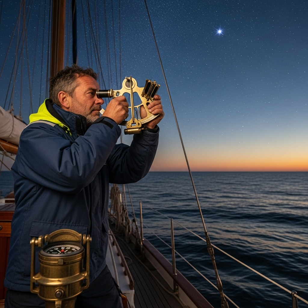
Determining position at sea using celestial observations:

“Using sextant, chronometer and nautical tables, calculating Latitude by the meridian altitude of the sun and Longitude by the method of lunar distances, considering atmospheric and instrumental corrections.”

Understanding and applying the principles of nautical astronomy:

“Calculate the position using observations of celestial bodies, considering declination, right ascension and AHG.”

Use astronomical navigation instruments skillfully:

Interpret and correct position errors arising from drift and current with accuracy.

Adapting to navigation in adverse weather conditions:

Interpret the available meteorological information (bulletins, radars, buoys) and adjust navigation planning to minimize risks and optimize the safety of the vessel and crew.

Interpreting and correcting errors in astronomical readings:

“Identify and mitigate sources of systematic and random error by validating data with multiple sources and applying smoothing techniques.”

Curriculum - Modules

  1. Comprehensive Maritime Incident Management: protocols, roles, and chain of command for coordinated response
  2. Operational Planning and Execution: briefing, routes, weather windows, and go/no-go criteria
  3. Rapid Risk Assessment: criticality matrix, scene control, and decision-making under pressure
  4. Operational Communication: VHF/GMDSS, standardized reports, and inter-agency liaison
  5. Tactical Mobility and Safe Boarding: RHIB maneuvers, approach, mooring, and recovery
  6. Equipment and Technologies: PPE, signaling, satellite tracking, and field data logging
  7. Immediate Care of the Affected: primary assessment, hypothermia, trauma, and stabilization for evacuation
  8. Adverse Environmental Conditions: swell, Visibility, flows, and operational mitigation

    Simulation and training: critical scenarios, use of VR/AR, and exercises with performance metrics

    Documentation and continuous improvement: lessons learned, indicators (MTTA/MTTR), and SOP updates

  1. Introduction to Celestial Navigation: History, Principles, and Fundamentals
  2. The Celestial Sphere: Horizontal, Equatorial, and Ecliptic Coordinates
  3. Nautical Instruments: Sextant, Marine Chronometer, and Nautical Almanac
  4. Measuring the Altitude of Celestial Bodies: Corrections and Calculating Observed Altitude
  5. Identifying Celestial Bodies: Stars, Planets, Sun, and Moon
  6. Calculating Geographic Position: Line of Position (LOP) and Circle of Altitude
  7. Determining Time: Coordinated Universal Time (UTC) and Local Sidereal Time (LST)
  8. Techniques for Reducing Sights: Algebraic Methods and Reduction Tables
  9. Drift and current: Calculation of estimated position (EP) and observed position (Fix)
  10. Integration with modern navigation: GPS, ECDIS, and inertial systems

  1. Introduction to nautical astronomy: history and basic concepts
  2. The celestial sphere: coordinates, apparent movements of the sun and stars
  3. Observational instruments: sextant, artificial horizon, chronometer
  4. Measuring altitudes: instrumental and atmospheric corrections
  5. Time: sidereal time, true and mean solar time, time zones
  6. Determining latitude by observing the sun to the meridian
  7. Determining latitude by observing Polaris
  8. Calculating longitude: difference in longitude and time (DLT)
  9. Identifying stars: using star charts and applications
  10. Modern Astronomical Navigation: Integration with GNSS and Software

  1. Introduction to Celestial Navigation: History, Fundamentals, and Applications
  2. The Celestial Sphere: Horizontal, Equatorial, and Ecliptic Coordinates
  3. Celestial Navigation Instruments: Sextant, Marine Chronometer, Nautical Almanac
  4. Measuring the Altitude of a Celestial Body: Instrumental and Atmospheric Corrections
  5. Calculating Position: Line of Position (LOP), Circle of Position
  6. Identifying Celestial Bodies: Use of Star Charts and Applications
  7. The Sun: Observation, Calculation of True Time and Meridian
  8. The Moon: Phases, Movement, and Use in Navigation
  9. Errors in Celestial Navigation: Sources and Mitigation
  10. Modern Celestial Navigation: Integration with electronic systems

  1. Introduction to nautical astrology: history, fundamentals, and applications
  2. Astronomical ephemerides: definition, types, sources, and use
  3. Celestial coordinates: reference systems, right ascension, declination
  4. Apparent motion of the Sun: equation of time, solar declination
  5. Lunar phases: influence on tides, calculation, and prediction
  6. Identification of stars and constellations: use of star charts and software
  7. Visible planets: motion, relative positions, and nautical applications
  8. Use of the sextant: altitude measurement, corrections, and calculations
  9. Determination of the Latitude: Observation of the North Star and the Sun

    Determination of longitude: Marine chronometer, time difference, and calculation

  1. System Architecture and Components: Structural design, materials, and subsystems (mechanical, electrical, electronic, and fluid) with selection and assembly criteria for marine environments
  2. Fundamentals and Principles of Operation: Physical and engineering foundations (thermodynamics, fluid mechanics, electricity, control, and materials) that explain performance and operating limits
  3. Safety and Environmental (SHE): Risk analysis, PPE, LOTO, hazardous atmospheres, spill and waste management, and emergency response plans
  4. Applicable Regulations and Standards: IMO/ISO/IEC requirements and local regulations;
  5. Conformance criteria, certification, and best practices for operation and maintenance
  6. Inspection, testing, and diagnostics: Visual/dimensional inspection, functional testing, data analysis, and predictive techniques (vibration, thermography, fluid analysis) to identify root causes
  7. Preventive and predictive maintenance: Hourly/cycle/seasonal plans, lubrication, adjustments, calibrations, consumable replacement, post-service verification, and operational reliability
  8. Instrumentation, tools, and metrology: Measuring and testing equipment, diagnostic software, calibration and traceability; selection criteria, safe use, and storage
  9. Onboard integration and interfaces: Mechanical, electrical, fluid, and data compatibility; Sealing and watertightness, EMC/EMI, corrosion protection, and interoperability testing.

    Quality, acceptance testing, and commissioning: process and materials control, FAT/SAT, bench and sea trials, go/no-go criteria, and evidence documentation.

    Technical documentation and integrated practice: logs, checklists, reports, and a complete case study (safety → diagnosis → intervention → verification → report) applicable to any system.

Plan de estudio - Módulos

  1. Comprehensive Maritime Incident Management: protocols, roles, and chain of command for coordinated response
  2. Operational Planning and Execution: briefing, routes, weather windows, and go/no-go criteria
  3. Rapid Risk Assessment: criticality matrix, scene control, and decision-making under pressure
  4. Operational Communication: VHF/GMDSS, standardized reports, and inter-agency liaison
  5. Tactical Mobility and Safe Boarding: RHIB maneuvers, approach, mooring, and recovery
  6. Equipment and Technologies: PPE, signaling, satellite tracking, and field data logging
  7. Immediate Care of the Affected: primary assessment, hypothermia, trauma, and stabilization for evacuation
  8. Adverse Environmental Conditions: swell, Visibility, flows, and operational mitigation

    Simulation and training: critical scenarios, use of VR/AR, and exercises with performance metrics

    Documentation and continuous improvement: lessons learned, indicators (MTTA/MTTR), and SOP updates

  1. Introduction to Celestial Navigation: History, Principles, and Fundamentals
  2. The Celestial Sphere: Horizontal, Equatorial, and Ecliptic Coordinates
  3. Nautical Instruments: Sextant, Marine Chronometer, and Nautical Almanac
  4. Measuring the Altitude of Celestial Bodies: Corrections and Calculating Observed Altitude
  5. Identifying Celestial Bodies: Stars, Planets, Sun, and Moon
  6. Calculating Geographic Position: Line of Position (LOP) and Circle of Altitude
  7. Determining Time: Coordinated Universal Time (UTC) and Local Sidereal Time (LST)
  8. Techniques for Reducing Sights: Algebraic Methods and Reduction Tables
  9. Drift and current: Calculation of estimated position (EP) and observed position (Fix)
  10. Integration with modern navigation: GPS, ECDIS, and inertial systems

  1. Introduction to nautical astronomy: history and basic concepts
  2. The celestial sphere: coordinates, apparent movements of the sun and stars
  3. Observational instruments: sextant, artificial horizon, chronometer
  4. Measuring altitudes: instrumental and atmospheric corrections
  5. Time: sidereal time, true and mean solar time, time zones
  6. Determining latitude by observing the sun to the meridian
  7. Determining latitude by observing Polaris
  8. Calculating longitude: difference in longitude and time (DLT)
  9. Identifying stars: using star charts and applications
  10. Modern Astronomical Navigation: Integration with GNSS and Software

  1. Introduction to Celestial Navigation: History, Fundamentals, and Applications
  2. The Celestial Sphere: Horizontal, Equatorial, and Ecliptic Coordinates
  3. Celestial Navigation Instruments: Sextant, Marine Chronometer, Nautical Almanac
  4. Measuring the Altitude of a Celestial Body: Instrumental and Atmospheric Corrections
  5. Calculating Position: Line of Position (LOP), Circle of Position
  6. Identifying Celestial Bodies: Use of Star Charts and Applications
  7. The Sun: Observation, Calculation of True Time and Meridian
  8. The Moon: Phases, Movement, and Use in Navigation
  9. Errors in Celestial Navigation: Sources and Mitigation
  10. Modern Celestial Navigation: Integration with electronic systems

  1. Introduction to nautical astrology: history, fundamentals, and applications
  2. Astronomical ephemerides: definition, types, sources, and use
  3. Celestial coordinates: reference systems, right ascension, declination
  4. Apparent motion of the Sun: equation of time, solar declination
  5. Lunar phases: influence on tides, calculation, and prediction
  6. Identification of stars and constellations: use of star charts and software
  7. Visible planets: motion, relative positions, and nautical applications
  8. Use of the sextant: altitude measurement, corrections, and calculations
  9. Determination of the Latitude: Observation of the North Star and the Sun

    Determination of longitude: Marine chronometer, time difference, and calculation

  1. System Architecture and Components: Structural design, materials, and subsystems (mechanical, electrical, electronic, and fluid) with selection and assembly criteria for marine environments
  2. Fundamentals and Principles of Operation: Physical and engineering foundations (thermodynamics, fluid mechanics, electricity, control, and materials) that explain performance and operating limits
  3. Safety and Environmental (SHE): Risk analysis, PPE, LOTO, hazardous atmospheres, spill and waste management, and emergency response plans
  4. Applicable Regulations and Standards: IMO/ISO/IEC requirements and local regulations;
  5. Conformance criteria, certification, and best practices for operation and maintenance
  6. Inspection, testing, and diagnostics: Visual/dimensional inspection, functional testing, data analysis, and predictive techniques (vibration, thermography, fluid analysis) to identify root causes
  7. Preventive and predictive maintenance: Hourly/cycle/seasonal plans, lubrication, adjustments, calibrations, consumable replacement, post-service verification, and operational reliability
  8. Instrumentation, tools, and metrology: Measuring and testing equipment, diagnostic software, calibration and traceability; selection criteria, safe use, and storage
  9. Onboard integration and interfaces: Mechanical, electrical, fluid, and data compatibility; Sealing and watertightness, EMC/EMI, corrosion protection, and interoperability testing.

    Quality, acceptance testing, and commissioning: process and materials control, FAT/SAT, bench and sea trials, go/no-go criteria, and evidence documentation.

    Technical documentation and integrated practice: logs, checklists, reports, and a complete case study (safety → diagnosis → intervention → verification → report) applicable to any system.

  1. Introduction to celestial navigation: history, fundamentals, and modern applications.
  2. Celestial sphere: coordinates, apparent motions, key concepts (ecliptic, equinoxes, etc.).
  3. Measuring instruments: sextant, artificial horizon, chronometer, nautical almanac.
  4. Measuring the altitudes of celestial bodies: instrumental, atmospheric, and observer corrections.
  5. Time: local time, GMT/UTC, time difference, calculation of sidereal time.
  6. Determining geographic position: line of position (LOP), position circle.
  7. Identifying stars: use of the nautical almanac and star charts.
  8. Navigation by the Sun: observations at sunrise, midday, and sunset.
  9. Navigation by the Moon and planets: particularities and special considerations.
  10. Integration with electronic navigation: verification and backup of GNSS systems.

  1. Introduction to Acoustic Navigation: history, fundamentals, and maritime applications.
  2. Celestial sphere: celestial coordinates, diurnal motion, ecliptic.
  3. Observational instruments: sextant, artificial horizon, chronometer.
  4. Instrumental corrections: sextant errors and their determination.
  5. Time: sidereal time, solar time, Coordinated Universal Time (UTC), equation of time.
  6. Nautical publications: Nautical almanac, reduction tables.
  7. Identification of celestial bodies: stars, planets, Moon, and Sun.
  8. Determining position by the altitude of a celestial body: line of position (LOP).
  9. Intersection of lines of Position: Obtaining the estimated position (EP).
  10. Calculating the position with the Sun at the meridian.

  1. Introduction to celestial navigation: history, fundamentals, and modern applications
  2. The celestial sphere: celestial coordinates (horizon, equatorial, ecliptic) and apparent motion of the sun, moon, and stars
  3. Instruments for celestial navigation: sextant, marine chronometer, nautical almanac, and reduction tables
  4. Measuring the altitude of celestial bodies: instrumental and atmospheric corrections
  5. Determining geographic position using solar observations: solar meridian and line of position
  6. Determining geographic position using star observations: identification and line of position
  7. Identifying stars and constellations: using planispheres and astronomical applications
  8. Calculating time: Universal Time Coordinated time (UTC), sidereal time, and equation of time

    Nautical dead reckoning: calculation of true course, distance traveled, and estimated position

    Dead reckoning correction: drift, current, and environmental factors

  1. Introduction to Celestial Navigation: History, Principles, and Basic Concepts
  2. Celestial Sphere: Celestial Coordinates (Right Ascension, Declination, etc.), Celestial Cardinal Points
  3. Instruments for Celestial Navigation: Sextant, Marine Chronometer, Nautical Almanac
  4. Measurements with the Sextant: Sextant Corrections, Observed Altitude, and True Altitude
  5. Time: Coordinated Universal Time (UTC), Sidereal Time, Equation of Time
  6. Nautical Almanac: Use and Interpretation of Almanac Tables
  7. Calculating Geographic Position: Line of Position, Intersection of Lines of Position
  8. Identifying Stars and Planets: Use of Planispheres and identification methods
  9. Drift due to currents and wind: calculating drift and its effect on position
  10. Precautions and common errors in celestial navigation: sources of error and how to minimize them

Career opportunities

  • Navigator on Vessels: Practical application of celestial navigation for safe and accurate navigation, especially in situations of electronic system failure.
  • Astronomical Navigation Instructor: Teaching the principles and techniques of celestial navigation to other mariners and maritime professionals.
  • Navigation Consultant: Advising shipowners and maritime operators on route optimization and navigational safety through the integration of astronomical methods.
  • Specialized Bridge Officer: Integrating astronomical navigation with modern navigation systems for greater safety and redundancy.
  • Research and Development: Participation in research projects to improve celestial navigation techniques and their application in new contexts.
  • Work in Planetariums and Maritime Observatories: Public outreach and education on celestial navigation for the general public.
  • Restoration and conservation of antique nautical instruments: Specialization in the identification, repair, and use of historical celestial navigation instruments.

“`

Admission requirements

Academic/professional profile:

Degree/Bachelor's degree in Nautical Science/Maritime Transport, Naval/Marine Engineering, or a related field; or proven professional experience in bridge/operations.

Language proficiency:

Recommended functional maritime English (SMCP) for simulations and technical materials.

5. Induction

Updated resume, copy of degree or seaman's book, ID card/passport, letter of motivation.

Technical requirements (for online):

Equipment with camera/microphone, stable connection, ≄ 24ā€ monitor recommended for ECDIS/Radar-ARPA.

Admission process and dates

1. Online
application

(form + documents).

2. Academic review and interview

(profile/objectives/schedule compatibility).

3. Admission decision

(+ scholarship proposal if applicable).

4. Reservation of place

(deposit) and registration.

5. Induction

(access to campus, calendars, simulator guides).

Scholarships and grants

  • Simplified Star Navigation: Learn the fundamentals of nautical astronomy to determine your position at sea, even without GPS.
  • Using the Sextant: Master using the sextant and measuring celestial angles, an essential skill for traditional navigation.
  • Identifying Stars and Constellations: Recognize the key stars and constellations for navigation, facilitating nighttime orientation.
  • Calculating Geographic Position: Apply astronomical methods to accurately calculate your latitude and longitude.
  • Safe and Independent Navigation: Acquire the tools for independent and reliable maritime navigation, increasing your safety at sea.
Master the sky and the sea: Become an expert star navigator.

Testimonials

Frequently asked questions

Yes. The itinerary includes ECDIS/Radar-ARPA/BRM with harbor, ocean, fog, storm, and SAR scenarios.

Online with live sessions; hybrid option for simulator/practical placements through agreements.

Recommended functional SMCP. We offer support materials for standard phraseology.

Yes, with a relevant degree or experience in maritime/port operations. The admissions interview will confirm suitability.

Optional (3–6 months) through Companies & Collaborations and the Alumni Network.

Simulator practice (rubrics), defeat plans, SOPs, checklists, micro-tests and applied TFM.

A degree from Navalis Magna University + operational portfolio (tracks, SOPs, reports and KPIs) useful for audits and employment.

  1. Introduction to Celestial Navigation: History, Principles, and Basic Concepts
  2. Celestial Sphere: Celestial Coordinates (Right Ascension, Declination, etc.), Celestial Cardinal Points
  3. Instruments for Celestial Navigation: Sextant, Marine Chronometer, Nautical Almanac
  4. Measurements with the Sextant: Sextant Corrections, Observed Altitude, and True Altitude
  5. Time: Coordinated Universal Time (UTC), Sidereal Time, Equation of Time
  6. Nautical Almanac: Use and Interpretation of Almanac Tables
  7. Calculating Geographic Position: Line of Position, Intersection of Lines of Position
  8. Identifying Stars and Planets: Use of Planispheres and identification methods
  9. Drift due to currents and wind: calculating drift and its effect on position
  10. Precautions and common errors in celestial navigation: sources of error and how to minimize them

Request information

  1. Complete the Application Form
  2. Attach your CV/Qualifications (if you have them to hand).
  3. Indicate your preferred cohort (January/May/September) and whether you want the hybrid option with simulator sessions.
An academic advisor will contact you within 24–48 hours to guide you through the admission process, scholarships, and compatibility with your professional schedule. Translated with DeepL.com (free version)
Please enable JavaScript in your browser to complete this form.
Click or drag a file to this area to upload.

Teachers

0
    0
    Tu carrito
    Tu carrito esta vacĆ­oRegresar a la tienda
    Scroll to Top