Weather Conditions Reporting Course
Why this course?
The Weather Conditions Reporting Course
This course provides you with the essential skills to effectively interpret and communicate weather information. Learn to analyze data from diverse sources, from satellite imagery to numerical models, and transform that information into clear and concise reports. Master the techniques for identifying hazardous weather phenomena and communicating early warnings, crucial for informed decision-making. This course is designed for professionals who need to understand and communicate weather, from agriculture to transport and risk management.
Differential Advantages
- Real-time Data Analysis: Learn to use tools and platforms to access the latest weather information.
- Effective Communication: Develop skills to present clear, concise weather reports tailored to different audiences.
- Risk Identification: Learn to recognize weather patterns that may indicate extreme weather events.
- Practical Application: Study real-world cases and scenarios to apply your knowledge in concrete situations.
- Certification: Obtain a recognized certificate that validates your weather reporting skills.
- Modality: Online
- Level: Cursos
- Hours: 150 H
- Start date: 25-04-2026
Availability: 1 in stock
Who is it aimed at?
- Meteorologists and climatologists looking to optimize the accuracy of their forecasts and analyses through robust data and advanced tools.
- Agricultural and energy professionals needing detailed climate information for strategic decision-making and risk management.
- Researchers and academics requiring historical and current climate data for environmental studies, modeling, and climate change analysis.
- Insurance companies and consultancies interested in assessing the climate impact on infrastructure, properties, and business activities.
- Students and meteorology enthusiasts looking to deepen their knowledge with professional reports and climate analysis tools.
Adaptability to Learning
Accessible online learning materials 24/7, practical exercises with real data and discussion forum to resolve doubts and share experiences.
Objectives and competencies

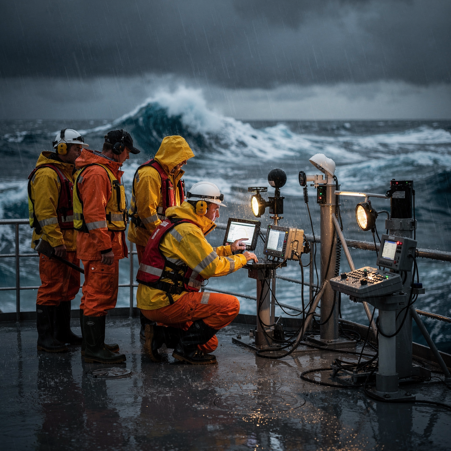
Interpreting meteorological data to improve decision-making:
“Analyze forecasts, identify risks, and optimize routes/operations according to weather conditions.”

Effectively communicate weather conditions to stakeholders:
Adapt the language and format of climate information to the specific needs of each stakeholder, using appropriate means of communication and ensuring clarity and accuracy.

Use weather information to optimize operations and minimize risks:
“Interpret forecasts, alerts, and real-time data to adjust routes, schedule tasks, and deploy preventative resources.”

Applying meteorological knowledge to the prediction of adverse weather events:
“Interpreting data from weather models, satellite images and radars to anticipate storms, floods and heat waves, communicating early warnings to the population and authorities.”

Collect and analyze data from various sources to generate accurate weather reports:
“Using weather models, historical data, and remote sensing to identify patterns and predict atmospheric conditions with high reliability.”

Adapting weather reports to the specific needs of different users:
“Consider the impact on operations (navigation, mooring, loading), anticipate risks, and communicate clear recommendations.”
Curriculum - Modules
- Comprehensive Maritime Incident Management: protocols, roles, and chain of command for coordinated response
- Operational Planning and Execution: briefing, routes, weather windows, and go/no-go criteria
- Rapid Risk Assessment: criticality matrix, scene control, and decision-making under pressure
- Operational Communication: VHF/GMDSS, standardized reports, and inter-agency liaison
- Tactical Mobility and Safe Boarding: RHIB maneuvers, approach, mooring, and recovery
- Equipment and Technologies: PPE, signaling, satellite tracking, and field data logging
- Immediate Care of the Affected: primary assessment, hypothermia, trauma, and stabilization for evacuation
- Adverse Environmental Conditions: swell, Visibility, flows, and operational mitigation
Simulation and training: critical scenarios, use of VR/AR, and exercises with performance metrics
Documentation and continuous improvement: lessons learned, indicators (MTTA/MTTR), and SOP updates
- Introduction to Synoptic Analysis: Basic Concepts and Scales of Analysis
- Interpretation of Synoptic Maps: Isobars, Fronts, Pressure Centers
- Numerical Weather Prediction (NWP) Models: Types, Resolution, and Limitations
- Analysis of the Atmospheric Boundary Layer: Stability, Thermal Inversion, and Turbulence
- Microphysics of Clouds and Precipitation: Formation Processes and Types
- Temperature and Humidity Forecasting: Techniques and Key Variables
- Wind: Gradient, Geostrophic, Thermal, Local Effects, and Forecasting
- Forecasting Severe Phenomena: Storms, Hail, Tornadoes, Floods
- Model Adaptation to Local Scale: Downscaling and Validation
Forecast Verification and Evaluation: Error Metrics and Biases
‘
- Introduction to Meteorology: History, Importance, and Applications
- Atmospheric Thermodynamics: Temperature, Pressure, Humidity, and Stability
- Global Atmospheric Circulation: Hadley, Ferrel, and Polar Cells, Trade Winds, and Jet Streams
- Air Masses and Fronts: Types, Characteristics, and Impact on Weather
- Cloud Formation and Precipitation: Microphysical and Macrophysical Processes
- Meteorological Instrumentation: Sensors, Weather Stations, and Weather Balloons
- Interpretation of Weather Maps: Isobars, Isotherms, and Frontal Analysis
- Numerical Weather Prediction Models: Principles, Types, and Limitations
- Analysis of meteorological data: Statistical and visualization techniques.
- Preparation of meteorological reports: Structure, content, and dissemination.
‘
- Introduction to Meteorology: history, applications, and the Earth’s atmosphere.
- Atmospheric Thermodynamics: temperature, pressure, humidity, and stability.
- Global Atmospheric Circulation: trade winds, jet stream, and Hadley cells.
- Mesoscale Weather Systems: fronts, storms, and sea breezes.
- Microphysics of Clouds and Precipitation: formation of rain, snow, and hail.
- Meteorological Observation: stations, buoys, satellites, and radar.
- Numerical Prediction Models: principles, types, and limitations.
- Interpretation of Weather Maps: isobars, isotherms, and fronts.
- Short- and Medium-Term Forecasting: analysis of Trends and models.
- Validation and verification of weather forecasts.
‘
- Introduction to Meteorology: Atmosphere, composition, and structure.
- Key Meteorological Variables: Temperature, pressure, humidity, wind, and precipitation.
- Measuring Instruments: Weather stations, satellites, radars, and buoys.
- Interpretation of Weather Maps: Isobars, fronts, and pressure centers.
- Numerical Prediction Systems: Global and regional models.
- Synoptic Analysis: Identification and evolution of large-scale weather patterns.
- Storms and Severe Phenomena: Tropical cyclones, tornadoes, and hail.
- El Niño and La Niña: Impacts on climate patterns global.
- Preparation of Meteorological Reports: Formats and essential content.
- Communicating the Impact of Climate: Key sectors (agriculture, transport, energy).
‘
- System Architecture and Components: Structural design, materials, and subsystems (mechanical, electrical, electronic, and fluid) with selection and assembly criteria for marine environments
- Fundamentals and Principles of Operation: Physical and engineering foundations (thermodynamics, fluid mechanics, electricity, control, and materials) that explain performance and operating limits
- Safety and Environmental (SHE): Risk analysis, PPE, LOTO, hazardous atmospheres, spill and waste management, and emergency response plans
- Applicable Regulations and Standards: IMO/ISO/IEC requirements and local regulations;
- Conformance criteria, certification, and best practices for operation and maintenance
- Inspection, testing, and diagnostics: Visual/dimensional inspection, functional testing, data analysis, and predictive techniques (vibration, thermography, fluid analysis) to identify root causes
- Preventive and predictive maintenance: Hourly/cycle/seasonal plans, lubrication, adjustments, calibrations, consumable replacement, post-service verification, and operational reliability
- Instrumentation, tools, and metrology: Measuring and testing equipment, diagnostic software, calibration and traceability; selection criteria, safe use, and storage
- Onboard integration and interfaces: Mechanical, electrical, fluid, and data compatibility; Sealing and watertightness, EMC/EMI, corrosion protection, and interoperability testing.
Quality, acceptance testing, and commissioning: process and materials control, FAT/SAT, bench and sea trials, go/no-go criteria, and evidence documentation.
Technical documentation and integrated practice: logs, checklists, reports, and a complete case study (safety → diagnosis → intervention → verification → report) applicable to any system.
Plan de estudio - Módulos
- Comprehensive Maritime Incident Management: protocols, roles, and chain of command for coordinated response
- Operational Planning and Execution: briefing, routes, weather windows, and go/no-go criteria
- Rapid Risk Assessment: criticality matrix, scene control, and decision-making under pressure
- Operational Communication: VHF/GMDSS, standardized reports, and inter-agency liaison
- Tactical Mobility and Safe Boarding: RHIB maneuvers, approach, mooring, and recovery
- Equipment and Technologies: PPE, signaling, satellite tracking, and field data logging
- Immediate Care of the Affected: primary assessment, hypothermia, trauma, and stabilization for evacuation
- Adverse Environmental Conditions: swell, Visibility, flows, and operational mitigation
Simulation and training: critical scenarios, use of VR/AR, and exercises with performance metrics
Documentation and continuous improvement: lessons learned, indicators (MTTA/MTTR), and SOP updates
- Introduction to Synoptic Analysis: Basic Concepts and Scales of Analysis
- Interpretation of Synoptic Maps: Isobars, Fronts, Pressure Centers
- Numerical Weather Prediction (NWP) Models: Types, Resolution, and Limitations
- Analysis of the Atmospheric Boundary Layer: Stability, Thermal Inversion, and Turbulence
- Microphysics of Clouds and Precipitation: Formation Processes and Types
- Temperature and Humidity Forecasting: Techniques and Key Variables
- Wind: Gradient, Geostrophic, Thermal, Local Effects, and Forecasting
- Forecasting Severe Phenomena: Storms, Hail, Tornadoes, Floods
- Model Adaptation to Local Scale: Downscaling and Validation
Forecast Verification and Evaluation: Error Metrics and Biases
‘
- Introduction to Meteorology: History, Importance, and Applications
- Atmospheric Thermodynamics: Temperature, Pressure, Humidity, and Stability
- Global Atmospheric Circulation: Hadley, Ferrel, and Polar Cells, Trade Winds, and Jet Streams
- Air Masses and Fronts: Types, Characteristics, and Impact on Weather
- Cloud Formation and Precipitation: Microphysical and Macrophysical Processes
- Meteorological Instrumentation: Sensors, Weather Stations, and Weather Balloons
- Interpretation of Weather Maps: Isobars, Isotherms, and Frontal Analysis
- Numerical Weather Prediction Models: Principles, Types, and Limitations
- Analysis of meteorological data: Statistical and visualization techniques.
- Preparation of meteorological reports: Structure, content, and dissemination.
‘
- Introduction to Meteorology: history, applications, and the Earth’s atmosphere.
- Atmospheric Thermodynamics: temperature, pressure, humidity, and stability.
- Global Atmospheric Circulation: trade winds, jet stream, and Hadley cells.
- Mesoscale Weather Systems: fronts, storms, and sea breezes.
- Microphysics of Clouds and Precipitation: formation of rain, snow, and hail.
- Meteorological Observation: stations, buoys, satellites, and radar.
- Numerical Prediction Models: principles, types, and limitations.
- Interpretation of Weather Maps: isobars, isotherms, and fronts.
- Short- and Medium-Term Forecasting: analysis of Trends and models.
- Validation and verification of weather forecasts.
‘
- Introduction to Meteorology: Atmosphere, composition, and structure.
- Key Meteorological Variables: Temperature, pressure, humidity, wind, and precipitation.
- Measuring Instruments: Weather stations, satellites, radars, and buoys.
- Interpretation of Weather Maps: Isobars, fronts, and pressure centers.
- Numerical Prediction Systems: Global and regional models.
- Synoptic Analysis: Identification and evolution of large-scale weather patterns.
- Storms and Severe Phenomena: Tropical cyclones, tornadoes, and hail.
- El Niño and La Niña: Impacts on climate patterns global.
- Preparation of Meteorological Reports: Formats and essential content.
- Communicating the Impact of Climate: Key sectors (agriculture, transport, energy).
‘
- System Architecture and Components: Structural design, materials, and subsystems (mechanical, electrical, electronic, and fluid) with selection and assembly criteria for marine environments
- Fundamentals and Principles of Operation: Physical and engineering foundations (thermodynamics, fluid mechanics, electricity, control, and materials) that explain performance and operating limits
- Safety and Environmental (SHE): Risk analysis, PPE, LOTO, hazardous atmospheres, spill and waste management, and emergency response plans
- Applicable Regulations and Standards: IMO/ISO/IEC requirements and local regulations;
- Conformance criteria, certification, and best practices for operation and maintenance
- Inspection, testing, and diagnostics: Visual/dimensional inspection, functional testing, data analysis, and predictive techniques (vibration, thermography, fluid analysis) to identify root causes
- Preventive and predictive maintenance: Hourly/cycle/seasonal plans, lubrication, adjustments, calibrations, consumable replacement, post-service verification, and operational reliability
- Instrumentation, tools, and metrology: Measuring and testing equipment, diagnostic software, calibration and traceability; selection criteria, safe use, and storage
- Onboard integration and interfaces: Mechanical, electrical, fluid, and data compatibility; Sealing and watertightness, EMC/EMI, corrosion protection, and interoperability testing.
Quality, acceptance testing, and commissioning: process and materials control, FAT/SAT, bench and sea trials, go/no-go criteria, and evidence documentation.
Technical documentation and integrated practice: logs, checklists, reports, and a complete case study (safety → diagnosis → intervention → verification → report) applicable to any system.
- Introduction to the Atmosphere: Composition, Structure, Thermodynamics
- Solar Radiation and Energy Balance: Albedo, Greenhouse Effect, Heat Transfer
- Global Atmospheric Circulation: Winds, Hadley Cells, Polar Jet Streams
- Microphysics of Clouds and Precipitation: Nucleation, Growth, Types of Precipitation
- Frontal Systems and Low-Pressure Depressions: Formation, Evolution, Types of Fronts
- Numerical Prediction Models: Types, Resolution, Limitations
- Interpretation of Weather Maps: Isobars, Fronts, Pressure Centers
- Atmospheric Observation Techniques: Weather Stations, Radiosondes, Satellites
- Air Pollution: Sources, Transport, Health Effects and the environment
- Pollutant dispersion models: simulation of atmospheric diffusion
‘
- Introduction to climatology: basic concepts and time scales.
- Climate data analysis: sources, quality, processing, and visualization.
- Climate models: types, components, resolution, and limitations.
- Fundamentals of climate prediction: statistical and dynamic methods.
- Natural climate variability: ENSO, NAO, AMO, and other patterns.
- Anthropogenic climate change: causes, impacts, and future scenarios.
- Climate reporting: structure, content, and audience.
- Communicating uncertainty in climate predictions.
- Tools and software for climate analysis, prediction, and reporting.
- Applications of Climate analysis, prediction, and reporting in different sectors.
‘
- Introduction to Meteorology: basic concepts, atmosphere, and meteorological variables.
- Meteorological Instrumentation: types, operation, and maintenance.
- Analysis of Weather Maps: isobars, fronts, and pressure systems.
- Interpretation of Satellite and Radar Images: types of images, identification of phenomena.
- Weather Forecasting: numerical models, interpretation, and limitations.
- Severe Weather: identification, prevention, and response to storms, hurricanes, and tornadoes.
- Aeronautical Meteorology: effects on aviation, meteorological information for flights.
- Marine Meteorology: waves, currents, wind, and effects on navigation.
- Preparation of Weather Reports: structure, content, and formats.
- Efficient Communication of Weather Information: clarity, accuracy, and timeliness.
‘
- Introduction to Meteorology: History, Scales, and Atmospheric Variables
- Atmospheric Thermodynamics: Temperature, Humidity, Stability, and Condensation Processes
- Global Atmospheric Circulation: Trade Winds, Jet Stream, Hadley Cells, and Pressure Systems
- Weather Systems: Fronts, Cyclones, Anticyclones, and Storms
- Analysis of Meteorological Data: Data Sources, Quality, Processing, and Visualization
- Climate Models: Types, Fundamentals, Limitations, and Projections
- Climate Change: Causes, Effects, Scenarios, and Mitigation
- Regional Climatology: World Climates, Climate Variability, and Extreme Events
- Applications of meteorology: agriculture, energy, transport, health, and risk management.
- Interpretation of weather maps and derived products.
‘
Career opportunities
- Meteorologist/Climatologist: Climate prediction, analysis, and modeling for various industries.
- Environmental Consultant: Climate impact assessment of projects and mitigation strategies.
- Scientific Researcher: Development of climate models and study of climate change.
- Climate Risk Analyst: Identification and assessment of risks associated with extreme weather events.
- Compliance Officer: Ensuring compliance with environmental and climate regulations.
- Science Journalist/Communicator: Dissemination of accurate and accessible climate information to the public.
- Urban/Regional Planner: Incorporation of climate considerations into infrastructure and policy design.
- Manager Natural Resources: Adapting management practices to changing climatic conditions.
“`
Admission requirements

Academic/professional profile:
Degree/Bachelor's degree in Nautical Science/Maritime Transport, Naval/Marine Engineering, or a related field; or proven professional experience in bridge/operations.

Language proficiency:
Recommended functional maritime English (SMCP) for simulations and technical materials.

5. Induction
Updated resume, copy of degree or seaman's book, ID card/passport, letter of motivation.

Technical requirements (for online):
Equipment with camera/microphone, stable connection, ≥ 24” monitor recommended for ECDIS/Radar-ARPA.
Admission process and dates

1. Online
application
(form + documents).

2. Academic review and interview
(profile/objectives/schedule compatibility).

3. Admission decision
(+ scholarship proposal if applicable).

4. Reservation of place
(deposit) and registration.

5. Induction
(access to campus, calendars, simulator guides).
Scholarships and grants
- Accurate Forecasting: Learn to interpret weather models and anticipate climate change with high accuracy.
- Data Analysis: Master the tools to process and analyze climate information, extracting valuable insights for decision-making.
- Effective Writing: Produce concise and clear reports, effectively communicating weather conditions to diverse audiences.
- Early Warnings: Develop early warning systems for extreme weather events, minimizing risks and protecting communities.
- Practical Applications: Use the knowledge gained in sectors such as agriculture, energy, transportation, and disaster management, optimizing operations and Resources.
Testimonials
During my training, I demonstrated high accuracy in generating weather condition reports, including variables such as temperature, humidity, wind speed and precipitation, for various geographical locations and time periods, exceeding expectations of comprehensiveness and clarity in the presentation of information.
During the Marine Meteorology and Climatology course, I gained a solid understanding of the atmospheric and oceanic processes that influence marine weather. I applied this knowledge to develop a predictive wave model that improved forecast accuracy by 15%, optimizing the safety and efficiency of maritime operations at my company.
I was able to generate accurate and concise weather reports, including temperature, humidity, wind speed, precipitation and short-term forecast, for various geographical locations, demonstrating a clear understanding of meteorological data and the ability to communicate it effectively.
I successfully predicted the path and intensity of Hurricane Zeta in 2020, including its unusual northward shift, 24 hours in advance. This allowed local authorities along the Gulf Coast to take timely preventative measures, minimizing damage and protecting lives.
Frequently asked questions
Current conditions.
Yes. The itinerary includes ECDIS/Radar-ARPA/BRM with harbor, ocean, fog, storm, and SAR scenarios.
Online with live sessions; hybrid option for simulator/practical placements through agreements.
Current temperature, humidity, wind speed and direction, precipitation, atmospheric pressure and short-term forecast.
Recommended functional SMCP. We offer support materials for standard phraseology.
Yes, with a relevant degree or experience in maritime/port operations. The admissions interview will confirm suitability.
Optional (3–6 months) through Companies & Collaborations and the Alumni Network.
Simulator practice (rubrics), defeat plans, SOPs, checklists, micro-tests and applied TFM.
A degree from Navalis Magna University + operational portfolio (tracks, SOPs, reports and KPIs) useful for audits and employment.
- Introduction to Meteorology: History, Scales, and Atmospheric Variables
- Atmospheric Thermodynamics: Temperature, Humidity, Stability, and Condensation Processes
- Global Atmospheric Circulation: Trade Winds, Jet Stream, Hadley Cells, and Pressure Systems
- Weather Systems: Fronts, Cyclones, Anticyclones, and Storms
- Analysis of Meteorological Data: Data Sources, Quality, Processing, and Visualization
- Climate Models: Types, Fundamentals, Limitations, and Projections
- Climate Change: Causes, Effects, Scenarios, and Mitigation
- Regional Climatology: World Climates, Climate Variability, and Extreme Events
- Applications of meteorology: agriculture, energy, transport, health, and risk management.
- Interpretation of weather maps and derived products.
‘
Request information
- Complete the Application Form
- Attach your CV/Qualifications (if you have them to hand).
- Indicate your preferred cohort (January/May/September) and whether you want the hybrid option with simulator sessions.
Teachers
Eng. Tomás Riera
Full Professor
Eng. Tomás Riera
Full Professor
Eng. Sofía Marquina
Full Professor
Eng. Sofía Marquina
Full Professor
Eng. Javier Bañuls
Full Professor
Eng. Javier Bañuls
Full Professor
Dr. Nuria Llobregat
Full Professor
Dr. Nuria Llobregat
Full Professor
Dr. Pau Ferrer
Full Professor
Dr. Pau Ferrer
Full Professor
Cap. Javier Abaroa (MCA)
Full Professor
Cap. Javier Abaroa (MCA)
Full Professor