Master’s Degree in Marine Storm Prediction Models

Why this master’s programme?

The Master’s in Marine Storm Prediction Models

This program will equip you to master the most advanced tools and techniques for analyzing and forecasting extreme weather events in the ocean. Learn to interpret oceanographic and atmospheric data, develop high-resolution predictive models, and assess the impact of storms on coastal infrastructure and maritime activities. This program will enable you to become an expert in risk management and strategic decision-making in the face of marine weather threats.

Differential Advantages

  • Advanced Simulations: Use of cutting-edge software to model storm evolution.
  • Big Data Analysis: Processing and interpretation of large volumes of meteorological and oceanographic information.
  • Coastal Risk Management: Assessment of the vulnerability of coastal areas and design of mitigation strategies.
  • Collaboration with Experts: Interaction with leading professionals in marine storm research and prediction.
  • Practical Applications: Development of real-world projects for companies in the maritime sector and government agencies.
Modelos

Master’s Degree in Marine Storm Prediction Models

Availability: 1 in stock

Who is it aimed at?

  • Marine meteorologists and oceanographers seeking advanced specialization in the accurate forecasting of marine storms and their impacts.
  • Coastal engineers and port infrastructure managers who need robust tools for coastal risk planning, design, and mitigation.
  • Offshore energy and shipping professionals who require reliable predictions for operational decision-making and the security of their assets.
  • Researchers and academics interested in developing new models and techniques for studying and predicting extreme weather events at sea.
  • Environmental consultants and emergency management professionals seeking to strengthen their capabilities for risk assessment and response to natural disasters.

Academic Flexibility
 Adapted to working professionals: online format with live and recorded classes, discussion forums, and personalized tutoring.

Modelos

Objectives and skills

Optimizing coastal risk management:

“Identify, assess and mitigate specific risks in the coastal zone (meteorological, currents, traffic) using electronic charts, prediction systems and effective communications.”

Improve the accuracy of early warnings:

Integrate real-time meteorological and oceanographic data to anticipate risk situations and dynamically adjust alert thresholds.

Develop impact mitigation strategies:

Implement predefined contingency plans and adapt them to the real situation, prioritizing crew safety, ship integrity, and environmental protection.

Promoting innovation in predictive technologies:

Develop machine learning algorithms to optimize predictive maintenance, reducing costs and improving reliability.

Leading research into extreme weather phenomena:

“Design and implement innovative predictive models, collaborating with scientific institutions and adapting mitigation strategies in the face of severe weather events.”

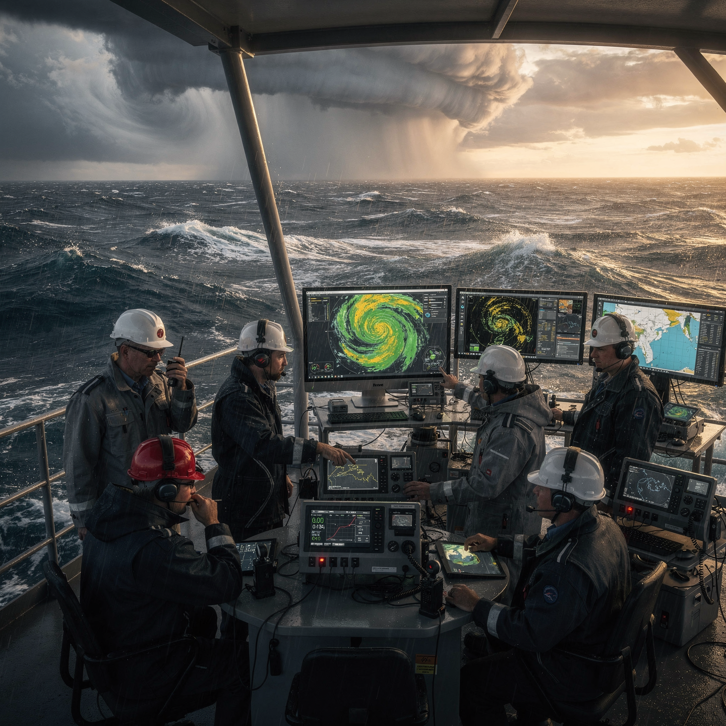
Interpreting and communicating complex data on marine storms:

“With precision and clarity, adapting the level of detail to the recipient (crew, authorities, public) and using effective visual resources (graphics, maps, simulations).”

Study plan – Modules

  1. Advanced Atmospheric Dynamics: Physicodynamic and Thermodynamic Processes in the Formation of Marine Storms
  2. Numerical Modeling of the Atmosphere: Fundamentals, Microphysical Parametrization, and Convection Schemes at the Sino- and Mesoscale Scales
  3. Spectral Analysis of Climate Patterns: Identification of Relevant Atmospheric and Oceanic Oscillation Modes (ENSO, NAO, MJO)
  4. Frontal Systems and Extratropical Cyclones: Characterization, Evolution, and Their Role in the Generation of Marine Storms
  5. Ocean-Atmosphere Interaction: Impact of Sea Surface Temperature (SST) and Humidity on the Intensification of Weather Systems
  6. Application of Remote Sensing and Real-Time Satellite Data for the Monitoring of Marine Weather Systems
  7. Integration of data from weather radars and ocean buoys for the validation and calibration of predictive models
  8. Statistical systems and machine learning applied to the analysis of climate time series and seasonal prediction of extreme events
  9. Configuration and management of pre-operational systems for early warnings based on dynamic and statistical storm models
  10. Case studies: retrospective analysis of historical marine storm events and evaluation of predictive accuracy
  11. Verification and validation protocols for meteorological models in complex marine environments
  12. Computational aspects: parallelization, spatiotemporal resolution, and optimization in marine atmospheric prediction models
  13. Critical evaluation of the limitations and sources of uncertainty in marine storm prediction
  14. Latest trends in research and development: data assimilation, hybrid models, and systems of Applied Artificial Intelligence

    Specialized seminars and practical workshops on advanced simulation, data analysis, and forecasting

  1. Fundamentals of remote sensing applied to coastal meteorology: physical principles, types of sensors and satellite platforms (optical, infrared, microwave, synthetic aperture radar – SAR)
  2. Advanced satellite image processing techniques: radiometric calibration, atmospheric correction, multispectral fusion and multitemporal analysis for the early detection of marine storms
  3. Interpretation of real-time remote sensing data: integration of satellite products with in-situ data, modeling of critical atmospheric and oceanographic variables
  4. Numerical hydrometeorological modeling in coastal areas: description of predictive models (WRF, ROMS, SWAN), parameterization of physical processes and atmospheric-oceanic coupling
  5. Implementation of data assimilation techniques to improve the accuracy of predictions: variational methods and Kalman filters applied to storms
  6. Marine Environments

  7. Simulation and forecasting of extreme waves and storm surges: advanced use of spectral models and validation with historical records and observation logs
  8. Development and integration of early warning systems based on artificial intelligence and machine learning for the automatic identification of precursor patterns of extreme events
  9. Operational monitoring and tracking: use of GIS geospatial platforms for dynamic visualization and real-time storm risk analysis
  10. Case studies of numerical modeling applied to vulnerable coastal regions: retrospective analysis and evaluation of predictive accuracy
  11. International standards and protocols for the management of early warnings in extreme weather events: integration with local policies and emergency response planning
  1. Theoretical Foundations of Atmospheric Dynamics: General Circulation, Pressure, Temperature, and Humidity in Marine Environments
  2. Identification and Characterization of Meteorological Systems: Tropical and Extratropical Cyclones, Fronts, and Local Disturbances
  3. Advanced Tools for Satellite and Weather Radar Analysis: Interpretation of Infrared, Visible, and Microwave Images
  4. Numerical Weather Prediction Models: Fundamentals, Governing Equations, Parametrizations, and Time Scales Relevant to Marine Storms
  5. Processing and Validation of In-Situ and Remote Data: Oceanographic Buoys, Coastal Meteorological Stations, and Marine Sensors
  6. Dynamics of Ocean-Atmosphere Interactions: Energy Transfer, Wind Effects on the Sea Surface, and Storm Feedback
  7. Spectral and Statistical Analysis of Climatic Variables: Time Series, Trends, Extremes and recurring patterns associated with severe events

    Methodologies for the early detection of convective and mesoscale events in marine environments

    Correlation of global climate indices (ENSO, NAO, AO) with the occurrence and evolution of marine storms

    Practical implementation of software for advanced modeling and visualization of meteorological patterns: WRF, HYSPLIT, applied meteorological GIS

  1. Fundamentals of stochastic modeling applied to waves and swells: theory of random processes and their relationship with coastal dynamics
  2. Advanced mathematical models for probabilistic wave simulation: energy spectra, distribution functions, and spatiotemporal correlations
  3. Real-time data assimilation techniques: fusion of satellite observations, oceanographic buoys, and coastal radar for forecast improvement
  4. Implementation of Kalman filters and Bayesian methods for continuous updating of predictive models
  5. Computational optimization of stochastic systems to ensure efficiency in critical operating environments
  6. Design and architecture of integrated coastal early warning systems: components, interfaces, and communication protocols
  7. Integration of hydrodynamic models with warning systems: automatic generation of alerts based on probabilistic risk thresholds
  8. Historical case studies of marine storms: validation and adjustment of predictive models with real data
  9. Uncertainty assessment in wave and swell predictions: metrics, sensitivity analysis, and mitigation techniques
  10. Development of real-time visualization and monitoring platforms: use of GIS, dashboards, and web tools for effective decision-making
  1. Fundamentals of atmospheric dynamics: convective structures and processes, vorticity, divergence, energy and momentum transport in marine storms
  2. Numerical models of atmospheric circulation: turbulence parameterization, cloud microphysics schemes in coastal systems
  3. Atmosphere-ocean interaction: heat, moisture, and momentum exchange in the marine boundary layer
  4. Dynamics of fronts and low-pressure systems: formation, evolution, and displacement in coastal regions
  5. Hydrodynamic modeling of marine storms: simulation of extreme winds, waves, and storm surges
  6. Integration of coupled atmosphere-ocean models for predictive forecasting at critical temporal and spatial scales
  7. Oceanographic variables: coastal currents, thermoclines, Stratification and its influence on storm intensification

    Advanced procedures for assimilating satellite and marine station data into predictive models

    Evaluation of the dynamic impact of marine storms on coastal infrastructure: analysis of hydrodynamic and structural forces

    Early warning and mitigation systems: design, calibration, and validation of predictive tools for decision-making in coastal planning

  1. Theoretical Foundations of Climate Modeling: Atmospheric and Oceanic Dynamics, Atmosphere-Sea Interaction, and Time Scales
  2. Advanced Principles of Remote Sensing: Active and Passive Sensors, Satellite Platforms, and Multispectral Image Processing
  3. Remote Sensing Systems: Weather Radar, LiDAR, and Radiometry for Marine Storm Monitoring
  4. Concepts of Stochastic Modeling Applied to Atmospheric Phenomena: Random Processes, Markov Chains, and Monte Carlo Simulation
  5. Multi-Source Integration: Fusion of Satellite, Oceanographic Buoy, and Meteorological Station Data for Climate Modeling
  6. Prediction Algorithms: Deep Neural Networks, Regression Models, and Time Series for Anticipating Events extremes
  7. Optimization and calibration of models using machine learning techniques and cross-validation
  8. Early warning systems: design and implementation, critical thresholds, and communication protocols
  9. Uncertainty assessment in climate predictions: sensitivity analysis and error propagation
  10. Case studies of integrated modeling and simulation for the accurate prediction of marine storms in different coastal regions
  1. Fundamentals of Remote Sensing Applied to Marine Meteorology: physical principles, active and passive sensors, electromagnetic waves and their interaction with the ocean surface.
  2. Meteorological and Oceanographic Satellites: classification, geostationary and polar orbits, key instruments (radar scatterometer, radiometers, altimeters) and their contribution to the early detection of marine storms.
  3. Remote Data Processing and Analysis: advanced techniques for extracting meteorological and oceanographic variables, atmospheric correction, sensor calibration, and multisensor data fusion.
  4. Numerical Modeling of the Atmosphere and Ocean: mathematical formulation of prediction models, Navier-Stokes equations, parameterization of physical processes, atmosphere-ocean coupling.
  5. Configuration and Execution of Numerical Models: selection Numerical schemes, adaptive meshing, initial and boundary conditions, and incorporation of observational data through assimilation.

    Simulation and Forecasting of Marine Storms: identification and monitoring of convective systems, dynamic and thermodynamic analysis of marine cyclones, and probabilistic assessment of their impact on coastal areas.

    Validation and Verification of Prediction Models: statistical metrics, comparison with in-situ and satellite data, sensitivity analysis, and parameter tuning for optimization of predictive performance.

    Integration of Early Warning Systems: operating system architecture, real-time information flow, and automated algorithms for generating weather alerts and risk assessment.

    Practical Applications in Marine Emergency Management: response protocols, inter-institutional coordination, and informed decision-making based on predictive models to minimize damage and save lives.

  6. Technological Advances and Future Trends in Remote Sensing and Numerical Modeling: artificial intelligence, machine learning for improved forecasting, increasing use of UAV platforms and nanosatellite constellations.
  1. Fundamentals of Data Assimilation: Concepts, History, and Evolution in Marine Meteorology
  2. Data Sources for Marine Storms: Satellites, Oceanographic Buoys, Coastal Radars, and Weather Stations
  3. Numerical Weather Prediction Models: Dynamic, Statistical, and Hybrid
  4. Advanced Assimilation Techniques: 3D-Var Variational, 4D-Var, and Extended Kalman Filters
  5. Implementation of Assimilation Algorithms in High-Resolution Regional Models for Coastal Environments
  6. Multi-Source Data Integration: Interoperability, Bias Correction, and Cross-Validation
  7. Stochastic Predictive Modeling for Risk Scenarios: Uncertainty, Sensitivity, and Probabilistic Analysis
  8. Model Optimization Using Machine Learning and Artificial Intelligence Techniques Applied to Storm Prediction marine environments
  9. Integrated Risk Management: Impact Assessment, Early Warnings, and Response Planning Based on Dynamic Predictions
  10. Case Studies and Practical Applications in Coastal Management: Damage Mitigation, Urban Planning, and Emergency Protocols
  11. Technological Platforms and Tools for Real-Time Monitoring and Continuous Updating of Predictive Models
  12. Simulation and Validation of the Integrated Prediction System: Statistical Techniques, Performance Metrics, and Continuous Adjustment
  13. International Regulations and Technical Standards in Data Management and Predictions for Maritime Security
  1. Fundamentals of remote sensing applied to marine storms: physical principles and active and passive satellite sensors
  2. Remote sensing data processing: atmospheric correction algorithms, extraction of oceanic parameters, and in-situ validation
  3. Numerical modeling of the atmosphere and ocean: coupled hydrodynamic and atmospheric models for the simulation of extreme events
  4. Dynamics of marine storms: analysis of formation, intensification, and dissipation based on thermodynamic and dynamic variables
  5. Assimilation of multimodal data: incorporation of satellite observations, oceanographic buoys, and coastal radars into predictive models
  6. Application of machine learning techniques for improving forecasts and the early detection of critical patterns
  7. Validation and adjustment of models using advanced statistical metrics and Probabilistic ensembles
  8. Uncertainty management in meteorological and oceanographic forecasting: stochastic methods and sensitivity analysis

    Implementation of integrated early warning systems: architecture, protocols, and risk communication to end users

    International case studies: detailed analysis of recent events with emphasis on mitigation and response strategies

  1. Introduction to the final project: objectives, scope, and relevance of the integrated prediction and early warning system for marine storms
  2. Scientific foundations: atmospheric and oceanic dynamics in marine storms, physical and chemical processes involved
  3. Numerical models for meteorological and oceanographic prediction: selection, parameterization, and validation for extreme coastal events
  4. Satellite and radar remote sensing: advanced image interpretation, pattern detection algorithms, and extraction of critical variables
  5. Design of multidimensional databases for real-time management of meteorological and oceanographic data
  6. Integration of stochastic techniques and probabilistic models for quantifying uncertainty and optimizing forecasts
  7. Data fusion methodologies: assimilation and joint processing of satellite information, numerical models, and in-situ observations
  8. Development of early warning algorithms: criteria for Threshold, risk analysis, and automated generation of alerts for end users

    Design and implementation of the integrated system with graphical interfaces for real-time visualization and monitoring

    Operational validation and calibration of the system using historical cases and experimental events

    Communication and alert dissemination protocols: interoperability with government entities and coastal communities

    Socio-environmental impact analysis and mitigation strategies based on predictions and early warnings

    Project management: planning, scheduling, quality control, and final system delivery

    Comprehensive technical documentation: operating manuals, scientific reports, and recommendations for future development

    Presentation and defense of the final project before an evaluation committee with a functional demonstration of the implemented system

Career prospects

“`html

  • Coastal Risk Analyst: Assessment and modeling of the vulnerability of coastal infrastructure and communities to extreme marine weather events.
  • Marine Renewable Energy Consultant: Optimization of the location and operation of offshore wind farms and other energy infrastructure, minimizing the impact of storms.
  • Research Scientist: Development of new prediction models, improvement of existing ones, and study of the impact of climate change on the frequency and intensity of marine storms.
  • Marine Meteorologist: Forecasting and early warning of marine storms for government institutions, private companies (insurance, shipping), and the general public.
  • Coastal Emergency Manager: Planning and coordination of responses to flooding and other natural disasters caused by marine storms.
  • Coastal Engineer: Design and construction of coastal infrastructure resilient to marine storms, such as dikes, breakwaters, and drainage systems.
  • Marine Insurance Specialist: Risk assessment and calculation of insurance premiums for vessels, infrastructure, and maritime activities, considering the risks associated with storms.
  • Public Policy Advisor: Development of strategies and regulations for climate change adaptation and the mitigation of coastal risks associated with marine storms.

“`

Entry requirements

Academic/professional profile:

Bachelor’s degree in Nautical Science/Maritime Transport, Naval/Marine Engineering or a related qualification; or proven professional experience on the bridge/in operations.

Language proficiency:

Functional Maritime English (SMCP) recommended for simulations and technical materials.

Documentation:

Updated CV, copy of qualification or seaman’s book, national ID/passport, motivation letter.

Technical requirements (for online):

Device with camera/microphone, stable internet connection, monitor ≥ 24” recommended for ECDIS/Radar-ARPA.

Admissions process and dates

Online
application

(form + documents).

Academic review and interview

Admissions decision

Admissions decision

(+ scholarship offer if applicable).

Place reservation

(deposit) and enrolment.

Induction

(access to the virtual campus, calendars, simulator guides).

Scholarships and financial support

  • Advanced Analysis: Master numerical models to predict the intensity and trajectory of marine storms.
  • Oceanographic Data: Learn to interpret satellite and buoy data to improve the accuracy of your forecasts.
  • Simulation and Visualization: Use cutting-edge tools to simulate scenarios and communicate risks effectively.
  • Risk Management: Develop strategies to mitigate the impact of storms on coastal infrastructure and maritime activities.
  • Applied Research: Participate in real-world projects and contribute to the advancement of weather prediction. extremes.
Become an expert in marine storm prediction and protect our coasts.

Testimonials

Frequently asked questions

The main focus is the development and application of predictive models for marine storms, including understanding the oceanographic and meteorological processes that generate them.

Yes. The itinerary includes ECDIS/Radar-ARPA/BRM with harbor, ocean, fog, storm, and SAR scenarios.

Online with live sessions; hybrid option for simulator/practical placements through agreements.

In both, he uses weather models to predict ocean conditions during storms.

Recommended functional SMCP. We offer support materials for standard phraseology.

Yes, with a relevant degree or experience in maritime/port operations. The admissions interview will confirm suitability.

Optional (3–6 months) through Companies & Collaborations and the Alumni Network.

Simulator practice (rubrics), defeat plans, SOPs, checklists, micro-tests and applied TFM.

A degree from Navalis Magna University + operational portfolio (tracks, SOPs, reports and KPIs) useful for audits and employment.

  1. Introduction to the final project: objectives, scope, and relevance of the integrated prediction and early warning system for marine storms
  2. Scientific foundations: atmospheric and oceanic dynamics in marine storms, physical and chemical processes involved
  3. Numerical models for meteorological and oceanographic prediction: selection, parameterization, and validation for extreme coastal events
  4. Satellite and radar remote sensing: advanced image interpretation, pattern detection algorithms, and extraction of critical variables
  5. Design of multidimensional databases for real-time management of meteorological and oceanographic data
  6. Integration of stochastic techniques and probabilistic models for quantifying uncertainty and optimizing forecasts
  7. Data fusion methodologies: assimilation and joint processing of satellite information, numerical models, and in-situ observations
  8. Development of early warning algorithms: criteria for Threshold, risk analysis, and automated generation of alerts for end users

    Design and implementation of the integrated system with graphical interfaces for real-time visualization and monitoring

    Operational validation and calibration of the system using historical cases and experimental events

    Communication and alert dissemination protocols: interoperability with government entities and coastal communities

    Socio-environmental impact analysis and mitigation strategies based on predictions and early warnings

    Project management: planning, scheduling, quality control, and final system delivery

    Comprehensive technical documentation: operating manuals, scientific reports, and recommendations for future development

    Presentation and defense of the final project before an evaluation committee with a functional demonstration of the implemented system

Request information

  1. Complete the Application Form.

  2. Attach your CV/degree certificate (if you have it to hand).

  3. Indicate your preferred cohort (January/May/September) and whether you would like the hybrid option with simulator sessions.

    An academic advisor will contact you within 24–48 hours to guide you through the admission process, scholarships, and compatibility with your professional schedule.

Please enable JavaScript in your browser to complete this form.
Click or drag a file to this area to upload.

Faculty

0
    0
    Tu carrito
    Tu carrito esta vacíoRegresar a la tienda
    Scroll to Top