Nautical Apps and Software Course

Why this course?

Master the digital sea with our Nautical Apps and Software course.

Learn to navigate with the most advanced tools, optimize your voyage, and maximize safety on board. Discover everything from route planning with digital charting to performance monitoring with instrumentation apps. This course will provide you with the practical knowledge to integrate technology into your navigation and make informed decisions.

Learn to navigate with the most advanced tools, optimize your voyage, and maximize safety on board.

Key Benefits

  • Advanced Navigation: Use apps to plan routes, monitor weather, and avoid hazards.
  • Enhanced Safety: Learn to interpret data from AIS, radar, and early warning systems.
  • Performance Optimization: Monitor fuel consumption, speed, and other key parameters.
  • Onboard Connectivity: Set up Wi-Fi networks, share data with your crew, and access real-time information.
  • Expert Support: Access tutorials, forums, and personalized assistance to get your questions answered.
Apps

Nautical Apps and Software Course

Availability: 1 in stock

Who is it aimed at?

  • Recreational and professional sailors looking to optimize planning and safety on their voyages with digital tools.
  • Sailing students and sailing enthusiasts interested in mastering the essential apps and software for modern navigation.
  • Sailing instructors and nautical schools wanting to integrate innovative technologies into their teaching programs.
  • Companies in the nautical sector looking to train their staff in the efficient use of navigation apps and software.
  • Nautical app developers needing to understand the needs and workflows of sailors.

Flexibility and applicability
 Adapted to Your pace: asynchronous online courses, access to downloadable resources and practical exercises with real-world applications.

Apps

Objectives and competencies

Optimize vessel management and maintenance:

Implement a preventive maintenance plan based on manufacturer recommendations and operational experience, optimizing costs and minimizing downtime.

Interpret and effectively use meteorological information for navigation:

Analyze forecasts, identify relevant weather systems (storms, fronts), and adjust navigation planning considering wind, waves, visibility, and currents, mitigating risks and optimizing the route.

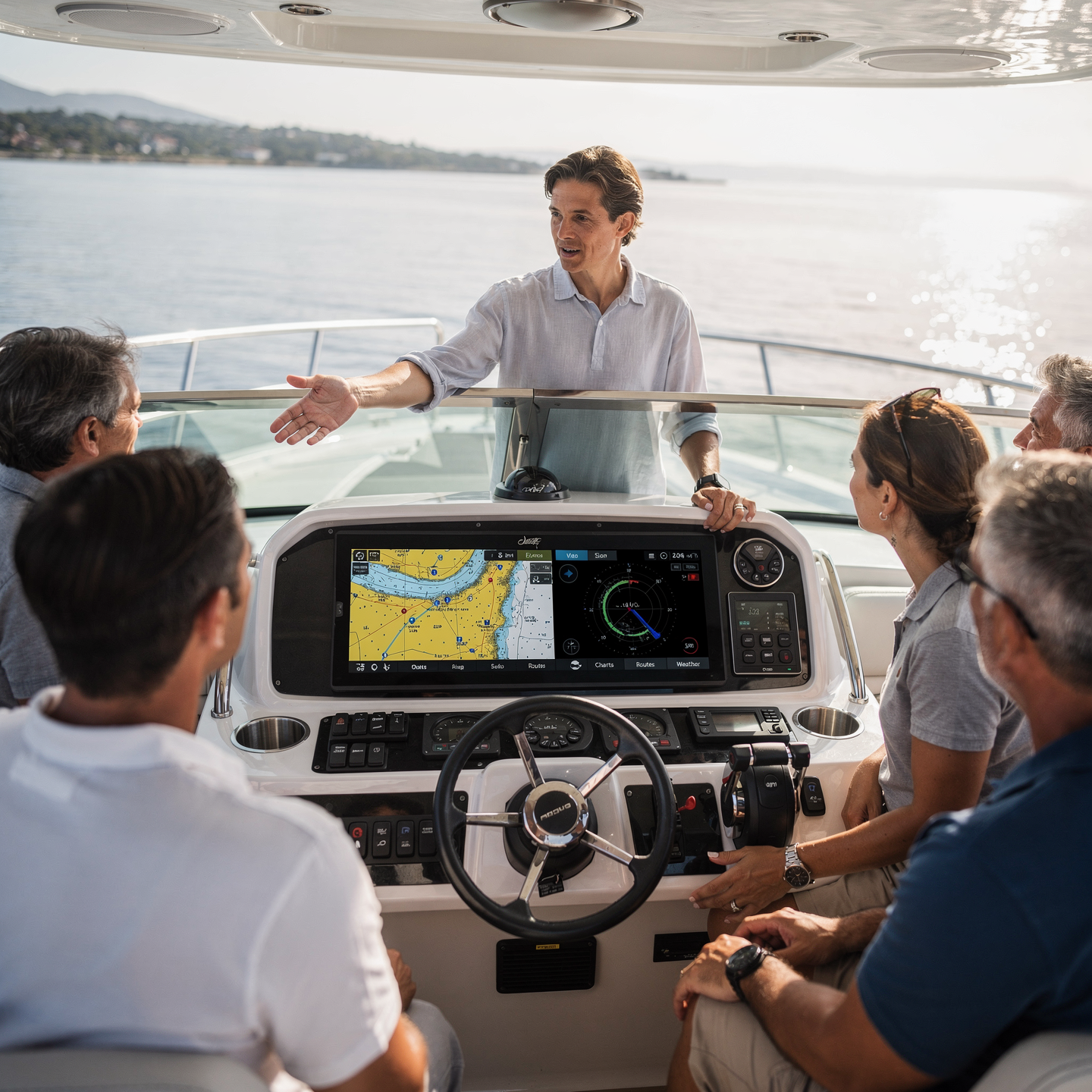
Proficiently use digital nautical charts and global positioning systems (GPS):

Interpreting chart information, planning efficient routes, and monitoring the vessel’s position in real time, optimizing fuel consumption and safety.

Diagnose and resolve common problems in on-board electronic systems:

“Identify faults, interpret schematics, use diagnostic tools and apply standard repair procedures, minimizing system downtime.”

Select and configure nautical applications and software suited to the specific needs of each vessel and voyage:

“Install, configure and calibrate navigation software (electronic charts, AIS, radar) integrating it with the vessel’s sensors (GPS, compass, anemometer) and verifying its correct communication and display.”

Automate navigation and vessel management tasks to improve efficiency and safety on board:

“Integrate control systems (autopilot, electronic navigation) optimizing routes and minimizing risks with expert judgment.”

Curriculum - Modules

  1. Comprehensive Maritime Incident Management: protocols, roles, and chain of command for coordinated response
  2. Operational Planning and Execution: briefing, routes, weather windows, and go/no-go criteria
  3. Rapid Risk Assessment: criticality matrix, scene control, and decision-making under pressure
  4. Operational Communication: VHF/GMDSS, standardized reports, and inter-agency liaison
  5. Tactical Mobility and Safe Boarding: RHIB maneuvers, approach, mooring, and recovery
  6. Equipment and Technologies: PPE, signaling, satellite tracking, and field data logging
  7. Immediate Care of the Affected: primary assessment, hypothermia, trauma, and stabilization for evacuation
  8. Adverse Environmental Conditions: swell, Visibility, flows, and operational mitigation

    Simulation and training: critical scenarios, use of VR/AR, and exercises with performance metrics

    Documentation and continuous improvement: lessons learned, indicators (MTTA/MTTR), and SOP updates

  1. Introduction to Electronic Cartography: History and Evolution
  2. Regulations and Standards: IMO, IEC, IHO, S-52, S-57, S-63, S-100
  3. Electronic Chart Systems: ECDIS, ECS, Differences and Requirements
  4. Electronic Nautical Charts (ENC): Structure, Formats, and Data Types
  5. Symbolism and Information Presentation: Interpretation and Effective Use
  6. Chart Updates: Methods, Sources, and Management of Notices to Mariners
  7. Aids to Navigation: Buoys, Lighthouses, Beacons, Radio Beacons, GNSS Systems
  8. Operation and Use of ECDIS Systems: Configuration, Alarms, and Security

    Integration with other systems: radar, AIS, GPS, gyrocompass

    Basic maintenance and troubleshooting of electronic mapping systems

  1. Introduction to Electronic Cartography: History, Evolution, and Regulations
  2. Electronic Nautical Chart Formats: Raster (RNC) and Vector (ENC)
  3. Geodetic Reference Systems: Datum, Map Projections, and Time Zones
  4. ECDIS: Functionalities, Performance Requirements, and IMO Standards
  5. Sensors and Peripherals: GPS, Gyro, Log, Echosounder, AIS
  6. Route Planning Tools: Creation, Editing, and Optimization
  7. Alarms and Warnings: Configuration, Priorities, and Management in ECDIS
  8. Updating Electronic Charts: Methods, Sources, and Responsibilities
  9. Time Navigation
  10. real: monitoring of position, heading, and speed

  11. Integration with other ship systems: radar, ARPA, autopilot

  1. Introduction to Electronic Cartography: History and Evolution
  2. Electronic Map Formats: Raster (RNC) and Vector (ENC)
  3. Geodetic Reference Systems: Datum, Ellipsoid, Projections
  4. ECDIS vs. ECS: Regulations, Standards, and Key Differences

    Nautical Symbols: Interpretation of Symbols and Abbreviations (INT1/S-4)

    Sources of Nautical Information: Charts, Publications, Notices to Mariners

    Chart Corrections: Manual and Automatic Updates

    Route Planning: Safety and Efficiency Considerations

    Navigation Tools: GPS, GNSS, AIS, Radar

    Data Integration and Real-Time Visualization

  1. Introduction to Electronic Cartography: History, Evolution, and Advantages
  2. Geodetic Reference Systems: Datum, Ellipsoids, and Map Projections
  3. Electronic Nautical Charts (ENC): S-57 Standard, Structure, and Content
  4. ECDIS: Components, IMO Regulations, and Main Functionalities
  5. ECDIS Installation and Configuration: Minimum Requirements, Sensor Calibration
  6. Using the ECDIS Interface: Menus, Tools, and Data Visualization
  7. Updating Electronic Charts: Procedures, Sources, and Amendment Management
  8. Integrating Navigation Sensors: GPS, Gyrocompass, Log, Radar, AIS
  9. Route Planning in ECDIS: Waypoint Definition, Alarms, and Verification

    Real-Time Navigation Monitoring: Alarms, Alerts, and Route Adjustments

  1. System Architecture and Components: Structural design, materials, and subsystems (mechanical, electrical, electronic, and fluid) with selection and assembly criteria for marine environments
  2. Fundamentals and Principles of Operation: Physical and engineering foundations (thermodynamics, fluid mechanics, electricity, control, and materials) that explain performance and operating limits
  3. Safety and Environmental (SHE): Risk analysis, PPE, LOTO, hazardous atmospheres, spill and waste management, and emergency response plans
  4. Applicable Regulations and Standards: IMO/ISO/IEC requirements and local regulations;
  5. Conformance criteria, certification, and best practices for operation and maintenance
  6. Inspection, testing, and diagnostics: Visual/dimensional inspection, functional testing, data analysis, and predictive techniques (vibration, thermography, fluid analysis) to identify root causes
  7. Preventive and predictive maintenance: Hourly/cycle/seasonal plans, lubrication, adjustments, calibrations, consumable replacement, post-service verification, and operational reliability
  8. Instrumentation, tools, and metrology: Measuring and testing equipment, diagnostic software, calibration and traceability; selection criteria, safe use, and storage
  9. Onboard integration and interfaces: Mechanical, electrical, fluid, and data compatibility; Sealing and watertightness, EMC/EMI, corrosion protection, and interoperability testing.

    Quality, acceptance testing, and commissioning: process and materials control, FAT/SAT, bench and sea trials, go/no-go criteria, and evidence documentation.

    Technical documentation and integrated practice: logs, checklists, reports, and a complete case study (safety → diagnosis → intervention → verification → report) applicable to any system.

Plan de estudio - Módulos

  1. Comprehensive Maritime Incident Management: protocols, roles, and chain of command for coordinated response
  2. Operational Planning and Execution: briefing, routes, weather windows, and go/no-go criteria
  3. Rapid Risk Assessment: criticality matrix, scene control, and decision-making under pressure
  4. Operational Communication: VHF/GMDSS, standardized reports, and inter-agency liaison
  5. Tactical Mobility and Safe Boarding: RHIB maneuvers, approach, mooring, and recovery
  6. Equipment and Technologies: PPE, signaling, satellite tracking, and field data logging
  7. Immediate Care of the Affected: primary assessment, hypothermia, trauma, and stabilization for evacuation
  8. Adverse Environmental Conditions: swell, Visibility, flows, and operational mitigation

    Simulation and training: critical scenarios, use of VR/AR, and exercises with performance metrics

    Documentation and continuous improvement: lessons learned, indicators (MTTA/MTTR), and SOP updates

  1. Introduction to Electronic Cartography: History and Evolution
  2. Regulations and Standards: IMO, IEC, IHO, S-52, S-57, S-63, S-100
  3. Electronic Chart Systems: ECDIS, ECS, Differences and Requirements
  4. Electronic Nautical Charts (ENC): Structure, Formats, and Data Types
  5. Symbolism and Information Presentation: Interpretation and Effective Use
  6. Chart Updates: Methods, Sources, and Management of Notices to Mariners
  7. Aids to Navigation: Buoys, Lighthouses, Beacons, Radio Beacons, GNSS Systems
  8. Operation and Use of ECDIS Systems: Configuration, Alarms, and Security

    Integration with other systems: radar, AIS, GPS, gyrocompass

    Basic maintenance and troubleshooting of electronic mapping systems

  1. Introduction to Electronic Cartography: History, Evolution, and Regulations
  2. Electronic Nautical Chart Formats: Raster (RNC) and Vector (ENC)
  3. Geodetic Reference Systems: Datum, Map Projections, and Time Zones
  4. ECDIS: Functionalities, Performance Requirements, and IMO Standards
  5. Sensors and Peripherals: GPS, Gyro, Log, Echosounder, AIS
  6. Route Planning Tools: Creation, Editing, and Optimization
  7. Alarms and Warnings: Configuration, Priorities, and Management in ECDIS
  8. Updating Electronic Charts: Methods, Sources, and Responsibilities
  9. Time Navigation
  10. real: monitoring of position, heading, and speed

  11. Integration with other ship systems: radar, ARPA, autopilot

  1. Introduction to Electronic Cartography: History and Evolution
  2. Electronic Map Formats: Raster (RNC) and Vector (ENC)
  3. Geodetic Reference Systems: Datum, Ellipsoid, Projections
  4. ECDIS vs. ECS: Regulations, Standards, and Key Differences

    Nautical Symbols: Interpretation of Symbols and Abbreviations (INT1/S-4)

    Sources of Nautical Information: Charts, Publications, Notices to Mariners

    Chart Corrections: Manual and Automatic Updates

    Route Planning: Safety and Efficiency Considerations

    Navigation Tools: GPS, GNSS, AIS, Radar

    Data Integration and Real-Time Visualization

  1. Introduction to Electronic Cartography: History, Evolution, and Advantages
  2. Geodetic Reference Systems: Datum, Ellipsoids, and Map Projections
  3. Electronic Nautical Charts (ENC): S-57 Standard, Structure, and Content
  4. ECDIS: Components, IMO Regulations, and Main Functionalities
  5. ECDIS Installation and Configuration: Minimum Requirements, Sensor Calibration
  6. Using the ECDIS Interface: Menus, Tools, and Data Visualization
  7. Updating Electronic Charts: Procedures, Sources, and Amendment Management
  8. Integrating Navigation Sensors: GPS, Gyrocompass, Log, Radar, AIS
  9. Route Planning in ECDIS: Waypoint Definition, Alarms, and Verification

    Real-Time Navigation Monitoring: Alarms, Alerts, and Route Adjustments

  1. System Architecture and Components: Structural design, materials, and subsystems (mechanical, electrical, electronic, and fluid) with selection and assembly criteria for marine environments
  2. Fundamentals and Principles of Operation: Physical and engineering foundations (thermodynamics, fluid mechanics, electricity, control, and materials) that explain performance and operating limits
  3. Safety and Environmental (SHE): Risk analysis, PPE, LOTO, hazardous atmospheres, spill and waste management, and emergency response plans
  4. Applicable Regulations and Standards: IMO/ISO/IEC requirements and local regulations;
  5. Conformance criteria, certification, and best practices for operation and maintenance
  6. Inspection, testing, and diagnostics: Visual/dimensional inspection, functional testing, data analysis, and predictive techniques (vibration, thermography, fluid analysis) to identify root causes
  7. Preventive and predictive maintenance: Hourly/cycle/seasonal plans, lubrication, adjustments, calibrations, consumable replacement, post-service verification, and operational reliability
  8. Instrumentation, tools, and metrology: Measuring and testing equipment, diagnostic software, calibration and traceability; selection criteria, safe use, and storage
  9. Onboard integration and interfaces: Mechanical, electrical, fluid, and data compatibility; Sealing and watertightness, EMC/EMI, corrosion protection, and interoperability testing.

    Quality, acceptance testing, and commissioning: process and materials control, FAT/SAT, bench and sea trials, go/no-go criteria, and evidence documentation.

    Technical documentation and integrated practice: logs, checklists, reports, and a complete case study (safety → diagnosis → intervention → verification → report) applicable to any system.

  1. Introduction to Electronic Cartography: History, Evolution, and Standards
  2. Electronic Chart Formats: Raster (RNC) vs. Vector (ENC)

    Reference Systems: Datum, Projections, Ellipsoids, and Coordinates

    Digital Navigation Equipment: ECDIS, GPS, AIS, Radar

    Installation and Configuration of Navigation Equipment

    Updating Electronic Charts: Procedures and Sources

    ECDIS: Functionalities, Settings, Symbols, and Display

    Route Planning in ECDIS: Waypoints, Distances, Estimated Times

    Alarms and Alerts: Configuration and Response in ECDIS

    Legal and Regulatory Considerations: IMO, SOLAS, STCW

  1. Introduction to Electronic Cartography: History, Evolution, and Formats
  2. Standards and Regulations: IMO, IEC, IHO, S-52, S-57, S-100
  3. Reference Systems: Datum, Map Projections, Ellipsoids
  4. ECDIS: Components, Functions, Display Modes, Security
  5. Electronic Nautical Charts (ENC): Structure, Content, Attributes
  6. Updating Electronic Charts: Methods, Providers, Management
  7. Navigation Aids: Types, Characteristics, Symbology (IALA)
  8. Integrating Sensors: GNSS, Log, Gyro, Echosounder, Radar
  9. Alarms and Warnings: Types, Priorities, Management ECDIS
  10. Practical considerations: planning, monitoring, risks and limitations

  1. Introduction to Electronic Cartography: History, Evolution, and Standards
  2. Electronic Chart Formats: Raster (RNC) and Vector (ENC)
  3. Geodetic Reference Systems: Datum, Map Projections, and Ellipsoids
  4. ECDIS Equipment: Hardware, Software, and Performance Requirements
  5. Electronic Chart Symbology and Presentation: S-52, Information Layers, and Objects
  6. Electronic Chart Corrections and Updates: Sources, Methods, and Responsibilities
  7. Integration of Navigation Sensors: GPS, Gyro, Log, and Echosounder
  8. Alarms and Alerts in ECDIS: Configuration, Priorities, and Responses
  9. Planning of Routes in ECDIS: Introduction of waypoints, verification, and optimization

    Use of electronic charts in different phases of navigation: coastal, oceanic, and in restricted waters

  1. Introduction to Electronic Cartography: History, Evolution, and Standards
  2. Coordinate Systems and Datums: WGS84, Map Projections, and Conversions
  3. Electronic Chart Formats: Raster Navigational Charts (RNC) and Electronic Navigational Charts (ENC)
  4. ECDIS Equipment: Components, Interfaces, and Performance Requirements
  5. Installation and Configuration of Navigation Simulation Software
  6. Types of Navigation Simulators: Full-Bridge, Desktop, and PC-Based
  7. Integration of Sensors in Simulators: GNSS, Gyro, Log, Radar
  8. Virtual Environments: Creating and Modifying Scenarios, Weather and Sea Modeling
  9. Use of data analysis tools: journey recording, performance evaluation.
  10. Calibration and maintenance of electronic mapping and simulation equipment.

Career opportunities

  • Nautical Application Developer: Creation and maintenance of apps for navigation, meteorology, fleet management, etc.
  • Nautical Software Developer: Design and development of software for navigation systems, simulation, engine control, etc.
  • Nautical Technology Consultant: Advising companies in the sector on the implementation of software and app solutions.
  • Specialized Technical Support: Resolution of technical problems related to nautical apps and software.
  • Nautical Data Analyst: Collection, analysis, and interpretation of data generated by apps and software to optimize operations and make informed decisions.
  • Nautical Cybersecurity Specialist: Protection of systems and data against cyber threats in the maritime environment.
  • Nautical Systems Integrator: Connecting and configuring different systems and devices through software and apps.
  • Nautical Software Tester: Ensuring the quality and functionality of applications and programs.

“`

Admission requirements

Academic/professional profile:

Degree/Bachelor's degree in Nautical Science/Maritime Transport, Naval/Marine Engineering, or a related field; or proven professional experience in bridge/operations.

Language proficiency:

Recommended functional maritime English (SMCP) for simulations and technical materials.

5. Induction

Updated resume, copy of degree or seaman's book, ID card/passport, letter of motivation.

Technical requirements (for online):

Equipment with camera/microphone, stable connection, ≥ 24” monitor recommended for ECDIS/Radar-ARPA.

Admission process and dates

1. Online
application

(form + documents).

2. Academic review and interview

(profile/objectives/schedule compatibility).

3. Admission decision

(+ scholarship proposal if applicable).

4. Reservation of place

(deposit) and registration.

5. Induction

(access to campus, calendars, simulator guides).

Scholarships and grants

  • Digital Navigation: Master the best apps and software for route planning, real-time tracking, and weather forecasting.
  • Onboard Safety: Learn how to use satellite communication tools, emergency alerts, and Automatic Identification Systems (AIS).
  • Optimization and Performance: Discover how to analyze navigation data to improve fuel efficiency and optimize your vessel’s performance.
  • Updates and Trends: Stay up-to-date with the latest technological innovations and learn how to integrate new apps and software into your boating routine.
  • Practical Cases: Apply your knowledge in realistic simulations and navigation exercises to solidify your learning.
Make the most of technology for safer, more efficient, and more enjoyable navigation.

Testimonials

Frequently asked questions

To facilitate navigation, route planning, consultation of nautical charts, weather information, tides and currents, and improve safety at sea.

Yes. The itinerary includes ECDIS/Radar-ARPA/BRM with harbor, ocean, fog, storm, and SAR scenarios.

Online with live sessions; hybrid option for simulator/practical placements through agreements.

Recommended functional SMCP. We offer support materials for standard phraseology.

Yes, with a relevant degree or experience in maritime/port operations. The admissions interview will confirm suitability.

Optional (3–6 months) through Companies & Collaborations and the Alumni Network.

Simulator practice (rubrics), defeat plans, SOPs, checklists, micro-tests and applied TFM.

A degree from Navalis Magna University + operational portfolio (tracks, SOPs, reports and KPIs) useful for audits and employment.

  1. Introduction to Electronic Cartography: History, Evolution, and Standards
  2. Coordinate Systems and Datums: WGS84, Map Projections, and Conversions
  3. Electronic Chart Formats: Raster Navigational Charts (RNC) and Electronic Navigational Charts (ENC)
  4. ECDIS Equipment: Components, Interfaces, and Performance Requirements
  5. Installation and Configuration of Navigation Simulation Software
  6. Types of Navigation Simulators: Full-Bridge, Desktop, and PC-Based
  7. Integration of Sensors in Simulators: GNSS, Gyro, Log, Radar
  8. Virtual Environments: Creating and Modifying Scenarios, Weather and Sea Modeling
  9. Use of data analysis tools: journey recording, performance evaluation.
  10. Calibration and maintenance of electronic mapping and simulation equipment.

Request information

  1. Complete the Application Form
  2. Attach your CV/Qualifications (if you have them to hand).
  3. Indicate your preferred cohort (January/May/September) and whether you want the hybrid option with simulator sessions.
An academic advisor will contact you within 24–48 hours to guide you through the admission process, scholarships, and compatibility with your professional schedule. Translated with DeepL.com (free version)
Please enable JavaScript in your browser to complete this form.
Click or drag a file to this area to upload.

Teachers

0
    0
    Tu carrito
    Tu carrito esta vacíoRegresar a la tienda
    Scroll to Top