Navigation Course in Adverse Conditions

Why this course?

Prepare to face the challenges of the sea with our Navigation in Adverse Conditions course.

Master the essential techniques and strategies to maintain your vessel’s course and safety in strong winds, heavy swells, reduced visibility, and other critical scenarios. Learn to interpret weather information, use navigation instruments accurately, and make quick and effective decisions under pressure. This course will provide you with the skills needed to navigate confidently and safely in any weather conditions.

Differential Advantages

  • Realistic Simulations: Experience extreme navigation situations in a controlled environment.
  • Real-Life Case Studies: Learn from the experiences of other sailors and maritime safety experts.
  • Survival Techniques: Acquire practical knowledge to deal with emergencies at sea.
  • Safe Route Planning: Develop skills to avoid risk zones and optimize your voyage.
  • Recognized Certification: Obtain a certificate that validates your competence in navigating in adverse conditions.
Navegación

Navigation Course in Adverse Conditions

Availability: 1 in stock

Who is it aimed at?

  • Captains and bridge officers seeking to improve their decision-making and execution capabilities in situations of low visibility, strong winds, and heavy swells.
  • Marine pilots and harbor pilots wishing to refine their navigation techniques in narrow channels, congested ports, and areas with complex currents.
  • Tugboat and support vessel personnel needing to optimize their coordination and maneuverability in challenging weather conditions.
  • Superintendents and fleet managers interested in reducing risks and improving the safety of their maritime operations in hostile environments.
  • Nautical students and maritime professionals seeking advanced, practical training to handle navigational situations demanding.

Flexibility and applicability:
Adapted to the demands of the sector: realistic simulations, case studies based on real incidents and onboard risk management tools.

Navegación

Objectives and competencies

Adapt navigation techniques:

Anticipate risks and opportunities by considering tides, currents, weather, and sea conditions.

Interpreting and responding to climate change:

Actively monitor weather forecasts and adapt routes/speeds to minimize impacts, considering the safety of cargo, crew and the environment.

Managing stress and staying calm:

Prioritize tasks, delegate efficiently, and maintain clear communication with the team, even under pressure.

Use navigation instruments without depending on visibility:

Integrate information from multiple sensors (radar, AIS, GPS) to create an accurate picture of the situation and anticipate potential conflicts.

Making effective decisions under pressure:

“Prioritize safety, assess risks quickly, and communicate the decision clearly to the team.”

Optimize the use of limited resources:

Plan the route considering currents, tides, drafts and route restrictions, minimizing fuel consumption and sailing time.

Curriculum - Modules

  1. Comprehensive Maritime Incident Management: protocols, roles, and chain of command for coordinated response
  2. Operational Planning and Execution: briefing, routes, weather windows, and go/no-go criteria
  3. Rapid Risk Assessment: criticality matrix, scene control, and decision-making under pressure
  4. Operational Communication: VHF/GMDSS, standardized reports, and inter-agency liaison
  5. Tactical Mobility and Safe Boarding: RHIB maneuvers, approach, mooring, and recovery
  6. Equipment and Technologies: PPE, signaling, satellite tracking, and field data logging
  7. Immediate Care of the Affected: primary assessment, hypothermia, trauma, and stabilization for evacuation
  8. Adverse Environmental Conditions: swell, Visibility, flows, and operational mitigation

    Simulation and training: critical scenarios, use of VR/AR, and exercises with performance metrics

    Documentation and continuous improvement: lessons learned, indicators (MTTA/MTTR), and SOP updates

  1. Introduction to Maritime Meteorology: History, Importance, and Applications in Navigation
  2. Atmosphere and its Layers: Composition, Temperature, Pressure, and Vertical Movements
  3. Wind: Formation, Scales, Gradient, Geostrophic Effects, Local Effects, and Prediction
  4. Air Masses and Fronts: Characteristics, Formation, Types, and Their Influence on Maritime Weather
  5. Clouds: Classification, Formation, Identification, and Relationship to Meteorological Phenomena
  6. Precipitation: Types, Formation, Measurement, and Impact on Navigation
  7. Fog: Types, Formation, Dissipation, and Effects on Maritime Visibility
  8. Sea Ice: Formation, Types, Distribution, Hazards, and Navigation Strategies in Cold Waters
  9. Waves and swells: formation, characteristics, prediction, and effects on vessel stability.
  10. Tropical storms and cyclones: formation, structure, movement, hazards, and safety measures.

  1. Introduction to Maritime Meteorology: basic concepts, scales, and meteorological variables.
  2. Onboard Meteorological Instrumentation: anemometers, barometers, thermometers, hygrometers, and their calibration.
  3. Observing the Sky and Clouds: identification, classification, and interpretation for weather forecasting.
  4. Atmospheric Pressure and Wind Systems: cyclones, anticyclones, low-pressure systems, fronts, and their impact on navigation.
  5. Waves and Sea State: generation, propagation, height, period, and direction.
  6. Wave prediction.

  7. Ocean currents and their influence: surface, deep, and tidal currents, and their interaction with wind.
  8. Sea ice: types of ice, formation, drift, navigational hazards, and avoidance strategies.
  9. Fog and reduced visibility: types of fog, formation conditions, and navigation techniques in fog.
  10. Marine meteorological information: information sources, forecasts, storm warnings, and their interpretation.
  11. Safe navigation strategies: route planning, speed selection, and adjusting navigation according to weather conditions.

  1. Introduction to Maritime Meteorology: History and Relevance to Navigation
  2. Earth’s Atmosphere: Composition, Structure, Pressure, and Temperature
  3. Wind: Formation, Scales (Beaufort), Local Effects (Breezes, Venturis)
  4. Clouds: Classification, Identification, and Relationship to Weather
  5. Precipitation: Types, Formation, and Effects on Visibility and Sea State
  6. Air Masses and Fronts: Characteristics, Types, and Evolution
  7. Pressure Systems: Anticyclones, Depressions, Cyclones, and Their Influence on Weather
  8. Waves: Formation, Types (Wind Swell, Ground Swell), Significant Height
  9. Ice Marine: Formation, types (ice pack, icebergs) and navigational hazards

    Meteorological instrumentation on board: anemometer, barometer, thermometer, hygrometer

  1. Introduction to Marine Meteorology: History, Importance, and Applications
  2. Earth’s Atmosphere: Composition, Structure, General and Regional Circulation
  3. Meteorological Variables: Temperature, Pressure, Humidity, Wind, and Cloud Cover
  4. Meteorological Instrumentation: Land-Based Stations and Marine Buoys
  5. Clouds and Precipitation: Types, Formation, Identification, and Forecasting
  6. Air Masses and Fronts: Characteristics, Classification, and Evolution
  7. Pressure Systems: Anticyclones, Cyclones, Depressions, and Troughs
  8. Marine Winds: Breezes, Trade Winds, Monsoons, and Local Winds (Land Wind, East Wind, etc.)
  9. Phenomena Dangerous weather events: storms, fog, ice, giant waves

    Sources of weather information: models, forecasts, warnings and alerts

  1. System Architecture and Components: Structural design, materials, and subsystems (mechanical, electrical, electronic, and fluid) with selection and assembly criteria for marine environments
  2. Fundamentals and Principles of Operation: Physical and engineering foundations (thermodynamics, fluid mechanics, electricity, control, and materials) that explain performance and operating limits
  3. Safety and Environmental (SHE): Risk analysis, PPE, LOTO, hazardous atmospheres, spill and waste management, and emergency response plans
  4. Applicable Regulations and Standards: IMO/ISO/IEC requirements and local regulations;
  5. Conformance criteria, certification, and best practices for operation and maintenance
  6. Inspection, testing, and diagnostics: Visual/dimensional inspection, functional testing, data analysis, and predictive techniques (vibration, thermography, fluid analysis) to identify root causes
  7. Preventive and predictive maintenance: Hourly/cycle/seasonal plans, lubrication, adjustments, calibrations, consumable replacement, post-service verification, and operational reliability
  8. Instrumentation, tools, and metrology: Measuring and testing equipment, diagnostic software, calibration and traceability; selection criteria, safe use, and storage
  9. Onboard integration and interfaces: Mechanical, electrical, fluid, and data compatibility; Sealing and watertightness, EMC/EMI, corrosion protection, and interoperability testing.

    Quality, acceptance testing, and commissioning: process and materials control, FAT/SAT, bench and sea trials, go/no-go criteria, and evidence documentation.

    Technical documentation and integrated practice: logs, checklists, reports, and a complete case study (safety → diagnosis → intervention → verification → report) applicable to any system.

Plan de estudio - Módulos

  1. Comprehensive Maritime Incident Management: protocols, roles, and chain of command for coordinated response
  2. Operational Planning and Execution: briefing, routes, weather windows, and go/no-go criteria
  3. Rapid Risk Assessment: criticality matrix, scene control, and decision-making under pressure
  4. Operational Communication: VHF/GMDSS, standardized reports, and inter-agency liaison
  5. Tactical Mobility and Safe Boarding: RHIB maneuvers, approach, mooring, and recovery
  6. Equipment and Technologies: PPE, signaling, satellite tracking, and field data logging
  7. Immediate Care of the Affected: primary assessment, hypothermia, trauma, and stabilization for evacuation
  8. Adverse Environmental Conditions: swell, Visibility, flows, and operational mitigation

    Simulation and training: critical scenarios, use of VR/AR, and exercises with performance metrics

    Documentation and continuous improvement: lessons learned, indicators (MTTA/MTTR), and SOP updates

  1. Introduction to Maritime Meteorology: History, Importance, and Applications in Navigation
  2. Atmosphere and its Layers: Composition, Temperature, Pressure, and Vertical Movements
  3. Wind: Formation, Scales, Gradient, Geostrophic Effects, Local Effects, and Prediction
  4. Air Masses and Fronts: Characteristics, Formation, Types, and Their Influence on Maritime Weather
  5. Clouds: Classification, Formation, Identification, and Relationship to Meteorological Phenomena
  6. Precipitation: Types, Formation, Measurement, and Impact on Navigation
  7. Fog: Types, Formation, Dissipation, and Effects on Maritime Visibility
  8. Sea Ice: Formation, Types, Distribution, Hazards, and Navigation Strategies in Cold Waters
  9. Waves and swells: formation, characteristics, prediction, and effects on vessel stability.
  10. Tropical storms and cyclones: formation, structure, movement, hazards, and safety measures.

  1. Introduction to Maritime Meteorology: basic concepts, scales, and meteorological variables.
  2. Onboard Meteorological Instrumentation: anemometers, barometers, thermometers, hygrometers, and their calibration.
  3. Observing the Sky and Clouds: identification, classification, and interpretation for weather forecasting.
  4. Atmospheric Pressure and Wind Systems: cyclones, anticyclones, low-pressure systems, fronts, and their impact on navigation.
  5. Waves and Sea State: generation, propagation, height, period, and direction.
  6. Wave prediction.

  7. Ocean currents and their influence: surface, deep, and tidal currents, and their interaction with wind.
  8. Sea ice: types of ice, formation, drift, navigational hazards, and avoidance strategies.
  9. Fog and reduced visibility: types of fog, formation conditions, and navigation techniques in fog.
  10. Marine meteorological information: information sources, forecasts, storm warnings, and their interpretation.
  11. Safe navigation strategies: route planning, speed selection, and adjusting navigation according to weather conditions.

  1. Introduction to Maritime Meteorology: History and Relevance to Navigation
  2. Earth’s Atmosphere: Composition, Structure, Pressure, and Temperature
  3. Wind: Formation, Scales (Beaufort), Local Effects (Breezes, Venturis)
  4. Clouds: Classification, Identification, and Relationship to Weather
  5. Precipitation: Types, Formation, and Effects on Visibility and Sea State
  6. Air Masses and Fronts: Characteristics, Types, and Evolution
  7. Pressure Systems: Anticyclones, Depressions, Cyclones, and Their Influence on Weather
  8. Waves: Formation, Types (Wind Swell, Ground Swell), Significant Height
  9. Ice Marine: Formation, types (ice pack, icebergs) and navigational hazards

    Meteorological instrumentation on board: anemometer, barometer, thermometer, hygrometer

  1. Introduction to Marine Meteorology: History, Importance, and Applications
  2. Earth’s Atmosphere: Composition, Structure, General and Regional Circulation
  3. Meteorological Variables: Temperature, Pressure, Humidity, Wind, and Cloud Cover
  4. Meteorological Instrumentation: Land-Based Stations and Marine Buoys
  5. Clouds and Precipitation: Types, Formation, Identification, and Forecasting
  6. Air Masses and Fronts: Characteristics, Classification, and Evolution
  7. Pressure Systems: Anticyclones, Cyclones, Depressions, and Troughs
  8. Marine Winds: Breezes, Trade Winds, Monsoons, and Local Winds (Land Wind, East Wind, etc.)
  9. Phenomena Dangerous weather events: storms, fog, ice, giant waves

    Sources of weather information: models, forecasts, warnings and alerts

  1. System Architecture and Components: Structural design, materials, and subsystems (mechanical, electrical, electronic, and fluid) with selection and assembly criteria for marine environments
  2. Fundamentals and Principles of Operation: Physical and engineering foundations (thermodynamics, fluid mechanics, electricity, control, and materials) that explain performance and operating limits
  3. Safety and Environmental (SHE): Risk analysis, PPE, LOTO, hazardous atmospheres, spill and waste management, and emergency response plans
  4. Applicable Regulations and Standards: IMO/ISO/IEC requirements and local regulations;
  5. Conformance criteria, certification, and best practices for operation and maintenance
  6. Inspection, testing, and diagnostics: Visual/dimensional inspection, functional testing, data analysis, and predictive techniques (vibration, thermography, fluid analysis) to identify root causes
  7. Preventive and predictive maintenance: Hourly/cycle/seasonal plans, lubrication, adjustments, calibrations, consumable replacement, post-service verification, and operational reliability
  8. Instrumentation, tools, and metrology: Measuring and testing equipment, diagnostic software, calibration and traceability; selection criteria, safe use, and storage
  9. Onboard integration and interfaces: Mechanical, electrical, fluid, and data compatibility; Sealing and watertightness, EMC/EMI, corrosion protection, and interoperability testing.

    Quality, acceptance testing, and commissioning: process and materials control, FAT/SAT, bench and sea trials, go/no-go criteria, and evidence documentation.

    Technical documentation and integrated practice: logs, checklists, reports, and a complete case study (safety → diagnosis → intervention → verification → report) applicable to any system.

  1. Introduction to Survival: Basic Principles and Mindset
  2. Survival Equipment: Life Rafts, Immersion Suits, EPIRB, SART
  3. Water Survival Techniques: Floating, Swimming, Rescue, Hypothermia
  4. Basic Maritime Meteorology: Winds, Pressure, Temperature, Humidity
  5. Waves and Currents: Formation, Types, Effects on Navigation and Survival
  6. Weather Forecasting: Information Sources, Interpreting Bulletins
  7. Maritime Risk Management: Identification, Assessment, Mitigation
  8. First Aid at Sea: Treatment of Injuries, Common Illnesses
  9. Emergency Communications: VHF, DSC, distress call procedures
  10. Emergency Drills: abandon ship, firefighting, search and rescue

  1. Introduction to Marine Meteorology: History, Importance, Meteorological Services
  2. Atmosphere: Composition, Structure, Pressure, Temperature, Wind, Humidity
  3. Clouds and Precipitation: Classification, Formation, Identification
  4. Air Masses and Fronts: Types, Characteristics, Effects on Navigation
  5. Pressure Systems: Anticyclones, Lows, Troughs, Ridges
  6. Winds: Beaufort Scale, Geostrophic Winds, Trade Winds, Monsoons, Local Winds
  7. Waves: Formation, Height, Period, Direction, Prediction
  8. Sea Ice: Formation, Types, Risks, Navigation in Cold Waters
  9. Instrumentation Meteorological: barometers, thermometers, anemometers, wind vanes, hygrometers
  10. Meteorological information sources: radio facsimile, NAVTEX, Internet, GMDSS

  1. Extreme Marine Meteorology: Prediction and analysis of hazardous phenomena.
  2. Survival at Sea: Survival equipment, life rafts, rescue techniques.
  3. First Aid in Adverse Conditions: Treatment of hypothermia, burns, traumatic injuries.
  4. Emergency Communication: Distress call procedures, satellite communication equipment.
  5. Floating and Swimming Techniques: Cold water survival, survival swimming.
  6. Psychology of Survival: Mental resilience, decision-making under pressure, maintaining morale.
  7. Evacuation Maneuvers: Abandon ship, use of emergency slides, Rescue procedures.
  8. Emergency Navigation: Use of sextant, basic celestial navigation, determining position without GPS.

    Emergency Repairs On Board: Damage control, plugging leaks, stabilizing the vessel.

    Maritime Law and International Conventions: SOLAS, SAR, maritime safety regulations.

  1. Introduction to Marine Meteorology: Atmosphere, General Circulation, Air Masses
  2. Onboard Meteorological Instrumentation: Barometer, Thermometer, Anemometer, Hygrometer
  3. Clouds and Precipitation: Identification, Formation, Implications for Navigation
  4. Wind: Scales (Beaufort), Gradient, Breezes, Local Effects, Forecasting
  5. Swells: Generation, Propagation, Height, Period, Effects on Navigation
  6. Ocean Currents: Types, Causes, Influence on Swells and Navigation
  7. Sea Ice: Formation, Types, Hazards, Navigation Routes in Ice-Containing Areas
  8. Pressure Systems: Anticyclones, Depressions, Fronts, Low-Pressure Systems, Low-Pressure Systems risks
  9. Meteorological information: sources (radio, fax, satellite, internet), chart interpretation
  10. Optimized routes according to weather conditions and sea state

Career opportunities

  • Bridge Officer in Adverse Conditions: Expert in navigation in reduced visibility, strong currents, or extreme weather.
  • Captain (Competency Development): Decision-making in critical situations, emergency management, and leadership in difficult conditions.
  • Sea Rescue Specialist: Participation in rescue and assistance operations in adverse conditions.
  • Tug Operator in Extreme Conditions: Safe towing maneuvers in storms or difficult-to-access areas.
  • Adverse Navigation Simulation Instructor: Training professionals to face complex and dangerous scenarios.
  • Maritime Safety Consultant: Risk assessment and development of protocols for navigation in adverse conditions.
  • Maritime Inspector: Verification of compliance with safety regulations and preparation for adverse conditions.
  • Marine Accident Investigator: Analysis of causes and contributing factors in incidents occurring under adverse conditions.

“`

Admission requirements

Academic/professional profile:

Degree/Bachelor's degree in Nautical Science/Maritime Transport, Naval/Marine Engineering, or a related field; or proven professional experience in bridge/operations.

Language proficiency:

Recommended functional maritime English (SMCP) for simulations and technical materials.

5. Induction

Updated resume, copy of degree or seaman's book, ID card/passport, letter of motivation.

Technical requirements (for online):

Equipment with camera/microphone, stable connection, ≄ 24ā€ monitor recommended for ECDIS/Radar-ARPA.

Admission process and dates

1. Online
application

(form + documents).

2. Academic review and interview

(profile/objectives/schedule compatibility).

3. Admission decision

(+ scholarship proposal if applicable).

4. Reservation of place

(deposit) and registration.

5. Induction

(access to campus, calendars, simulator guides).
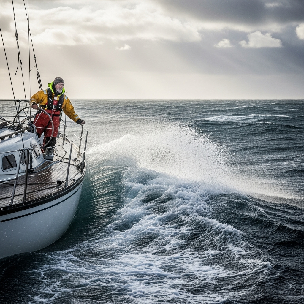
Scholarships and grants

  • Mastery of Techniques: Learn to navigate safely in extreme weather conditions and reduced visibility.
  • Decision-Making: Develop skills for planning and executing safe maneuvers in critical situations.
  • Equipment and Safety: Learn the optimal use of navigation equipment and essential safety protocols.
  • Realistic Simulation: Practice in simulated environments that replicate adverse conditions to improve your responsiveness.
  • Certification: Obtain a recognized certification that validates your competence in navigating in adverse conditions. adverse conditions.
Insure your vessel and crew against any eventuality; become an expert navigator.

Testimonials

Frequently asked questions

Unfavorable, contrary or difficult for safe navigation.

Yes. The itinerary includes ECDIS/Radar-ARPA/BRM with harbor, ocean, fog, storm, and SAR scenarios.

Online with live sessions; hybrid option for simulator/practical placements through agreements.

Check the safety equipment, including life rafts, life jackets, emergency position-indicating radio beacons (EPIRBs) and communications equipment, and make sure everything is in good working order and accessible.

Recommended functional SMCP. We offer support materials for standard phraseology.

Yes, with a relevant degree or experience in maritime/port operations. The admissions interview will confirm suitability.

Optional (3–6 months) through Companies & Collaborations and the Alumni Network.

Simulator practice (rubrics), defeat plans, SOPs, checklists, micro-tests and applied TFM.

A degree from Navalis Magna University + operational portfolio (tracks, SOPs, reports and KPIs) useful for audits and employment.

  1. Introduction to Marine Meteorology: Atmosphere, General Circulation, Air Masses
  2. Onboard Meteorological Instrumentation: Barometer, Thermometer, Anemometer, Hygrometer
  3. Clouds and Precipitation: Identification, Formation, Implications for Navigation
  4. Wind: Scales (Beaufort), Gradient, Breezes, Local Effects, Forecasting
  5. Swells: Generation, Propagation, Height, Period, Effects on Navigation
  6. Ocean Currents: Types, Causes, Influence on Swells and Navigation
  7. Sea Ice: Formation, Types, Hazards, Navigation Routes in Ice-Containing Areas
  8. Pressure Systems: Anticyclones, Depressions, Fronts, Low-Pressure Systems, Low-Pressure Systems risks
  9. Meteorological information: sources (radio, fax, satellite, internet), chart interpretation
  10. Optimized routes according to weather conditions and sea state

Request information

  1. Complete the Application Form
  2. Attach your CV/Qualifications (if you have them to hand).
  3. Indicate your preferred cohort (January/May/September) and whether you want the hybrid option with simulator sessions.
An academic advisor will contact you within 24–48 hours to guide you through the admission process, scholarships, and compatibility with your professional schedule. Translated with DeepL.com (free version)
Please enable JavaScript in your browser to complete this form.
Click or drag a file to this area to upload.

Teachers

0
    0
    Tu carrito
    Tu carrito esta vacĆ­oRegresar a la tienda
    Scroll to Top