Introduction to Coastal Navigation Course
Why this course?
The Introduction to Coastal Navigation
This course provides you with the essential tools to explore the coastline safely and confidently. Learn the fundamentals of nautical charting, the use of the compass and GPS, the interpretation of maritime signals, and the rules of navigation. This practical course will prepare you to plan your voyages, avoid hazards, and get the most out of sailing or motoring along the coast.
This course provides you with the essential tools to explore the coastline safely and confidently. Learn the fundamentals of nautical charting, the use of the compass and GPS, the interpretation of maritime signals, and the rules of navigation. This practical course will prepare you to plan your voyages, avoid hazards, and fully enjoy coastal sailing or motoring.
Differential Advantages
- Practical Approach: navigation exercises with real charts and simulations.
- Maritime Safety: emergency protocols, basic meteorology, and VHF communication.
- Voyage Planning: calculation of tides, currents, and distances.
- Interpretation of Navigational Aids: buoys, beacons, and lighthouses.
- Experienced Instructors: professional navigators with extensive coastal experience.
- Modality: Online
- Level: Cursos
- Hours: 150 H
- Start date: 26-07-2026
Availability: 1 in stock
Who is it aimed at?
- Recreational sailors who want to learn the fundamentals of planning and executing safe coastal passages.
- Sailing beginners looking for a comprehensive introduction to nautical charts, instruments, and navigation rules.
- Boat crew members who want to improve their skills and actively contribute to coastal navigation.
- Sea lovers who aspire to obtain basic nautical licenses and navigate confidently close to the coast.
- Nature lovers who want to explore the coastline independently and responsibly, understanding the marine environment.
Learning flexibility
Ideal for people with busy schedules Tight: accessible content online 24/7, practical exercises and personalized tutoring to answer questions.
Objectives and competencies

Interpreting nautical charts and related publications:
“Identify symbols, interpret depths, hazards, navigational aids and restrictions, using up-to-date information and relevant corrections.”

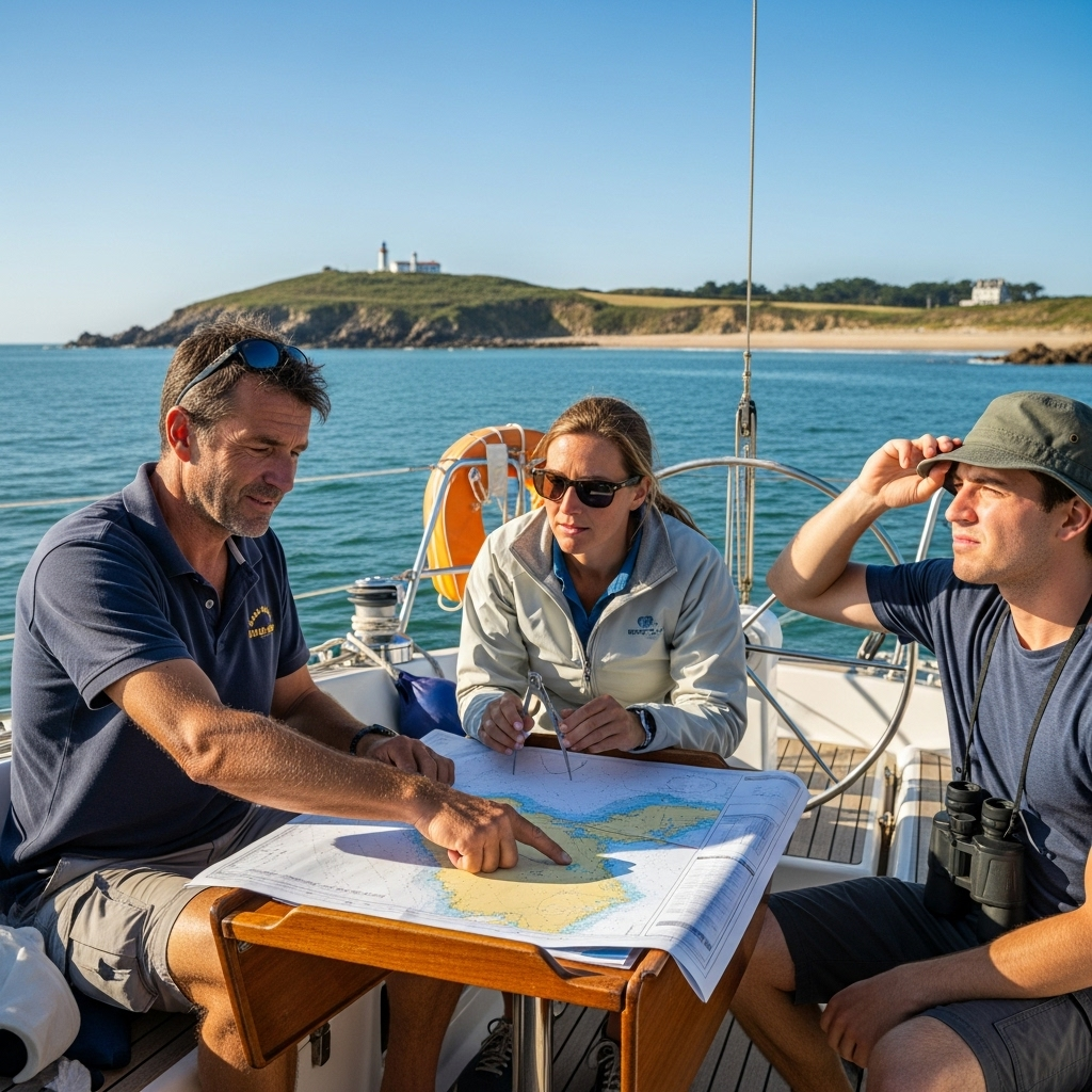
Use coastal navigation instruments accurately:
Interpret and apply information from nautical charts, tides, and nautical publications for the safe planning and execution of coastal navigation.

Apply navigation rules and avoid collisions on the coast:
“Maintain active listening on VHF, use electronic/visual navigation aids, and anticipate risks from currents/tides.”

Managing maritime safety and responding to emergencies in coastal navigation:
“Operate communication and GMDSS equipment.”
“Efficiently transmit and receive essential information for safety and SAR.”
“In critical situations, remain calm and follow established emergency protocols.”

Understanding environmental factors and their influence on coastal navigation:
Interpret nautical charts, tides, currents and weather conditions to optimize navigation planning and execution.

Determine the vessel's position using coastal navigation techniques:
“To effectively use nautical charts, compass, log and other coastal navigation instruments, considering drift and current, and applying the necessary corrections.”
Curriculum - Modules
- Comprehensive Maritime Incident Management: protocols, roles, and chain of command for coordinated response
- Operational Planning and Execution: briefing, routes, weather windows, and go/no-go criteria
- Rapid Risk Assessment: criticality matrix, scene control, and decision-making under pressure
- Operational Communication: VHF/GMDSS, standardized reports, and inter-agency liaison
- Tactical Mobility and Safe Boarding: RHIB maneuvers, approach, mooring, and recovery
- Equipment and Technologies: PPE, signaling, satellite tracking, and field data logging
- Immediate Care of the Affected: primary assessment, hypothermia, trauma, and stabilization for evacuation
- Adverse Environmental Conditions: swell, Visibility, flows, and operational mitigation
Simulation and training: critical scenarios, use of VR/AR, and exercises with performance metrics
Documentation and continuous improvement: lessons learned, indicators (MTTA/MTTR), and SOP updates
- Introduction to nautical charts: types, scales, and projections
- Nautical symbols: general, buoys, beacons, lights, and marks
- Soundings and depths: datum, depth reduction, safety
- Chart corrections: Notices to Mariners, nautical publications
- Tides: causes, types, components, and associated phenomena
- Tide prediction: graphical and numerical methods, tide tables
- Tidal currents: influence, chart representation, data
- Using nautical charts for voyage planning
- Calculating tidal heights: interpolation, time corrections
- Interpreting chart information nautical and its practical application
‘
- Introduction to Nautical Cartography: Chart types, projections, and datum.
- Symbols and Abbreviations: Interpretation of symbols, soundings, hazards, and navigational aids.
- Chart Corrections: Notices to Mariners, nautical publications, and their application.
- Tides: Causes, types, prediction, and calculation of tidal heights.
- Tidal Currents: Influence on navigation, current tables, and local effects.
- Nautical Publications: Sailing Directions, Lighthouses and Signals, Tide Tables, and other relevant publications.
- Navigation Equipment: Magnetic and gyroscopic compasses, log, sounding line, and GNSS.
- Maritime Safety: International regulations (SOLAS), emergency procedures, and safety equipment.
- Search and Rescue (SAR): Organization, procedures, and communications.
- First Aid: Basic survival techniques at sea.
‘
- Introduction to nautical cartography: history, chart types, projections.
- Nautical chart symbology: interpretation of symbols, abbreviations, and references.
- Soundings and depths: chart datum, corrections, navigational safety.
- Tides: causes, types, tide prediction, use of tide tables.
- Currents: types of currents, influence on navigation, current atlas.
- Nautical publications: sailing directions, notices to mariners, lists of lighthouses.
- Navigation instruments: compass, log, sextant, GPS.
- Chart correction Nautical charts: methods, importance, sources of information.
Planning the voyage: chart selection, calculating tides and currents, safe routes.
Practical use of nautical charts: navigation exercises, determining position, estimation.
‘
- Introduction to Maritime Safety: Conventions, Organizations, and Regulations
- Marine Meteorology: Cloud Formation, Pressure Systems, Winds, and Storms
- Meteorological Instrumentation: Barometer, Anemometer, Thermometer, Hygrometer
- Interpretation of Weather Bulletins and Storm Warnings
- Synoptic Charts: Analysis and Short-Term Weather Forecasting
- Maritime Communications: Radio Equipment, VHF, MF/HF, Inmarsat
- Distress Call Procedures: MAYDAY, PAN PAN, SECURITE
- GMDSS: Global Maritime Distress and Safety System
- SAR: Organization and search and rescue procedures
- New technologies in maritime communications: broadband, next-generation satellites
‘
- System Architecture and Components: Structural design, materials, and subsystems (mechanical, electrical, electronic, and fluid) with selection and assembly criteria for marine environments
- Fundamentals and Principles of Operation: Physical and engineering foundations (thermodynamics, fluid mechanics, electricity, control, and materials) that explain performance and operating limits
- Safety and Environmental (SHE): Risk analysis, PPE, LOTO, hazardous atmospheres, spill and waste management, and emergency response plans
- Applicable Regulations and Standards: IMO/ISO/IEC requirements and local regulations;
- Conformance criteria, certification, and best practices for operation and maintenance
- Inspection, testing, and diagnostics: Visual/dimensional inspection, functional testing, data analysis, and predictive techniques (vibration, thermography, fluid analysis) to identify root causes
- Preventive and predictive maintenance: Hourly/cycle/seasonal plans, lubrication, adjustments, calibrations, consumable replacement, post-service verification, and operational reliability
- Instrumentation, tools, and metrology: Measuring and testing equipment, diagnostic software, calibration and traceability; selection criteria, safe use, and storage
- Onboard integration and interfaces: Mechanical, electrical, fluid, and data compatibility; Sealing and watertightness, EMC/EMI, corrosion protection, and interoperability testing.
Quality, acceptance testing, and commissioning: process and materials control, FAT/SAT, bench and sea trials, go/no-go criteria, and evidence documentation.
Technical documentation and integrated practice: logs, checklists, reports, and a complete case study (safety → diagnosis → intervention → verification → report) applicable to any system.
Plan de estudio - Módulos
- Comprehensive Maritime Incident Management: protocols, roles, and chain of command for coordinated response
- Operational Planning and Execution: briefing, routes, weather windows, and go/no-go criteria
- Rapid Risk Assessment: criticality matrix, scene control, and decision-making under pressure
- Operational Communication: VHF/GMDSS, standardized reports, and inter-agency liaison
- Tactical Mobility and Safe Boarding: RHIB maneuvers, approach, mooring, and recovery
- Equipment and Technologies: PPE, signaling, satellite tracking, and field data logging
- Immediate Care of the Affected: primary assessment, hypothermia, trauma, and stabilization for evacuation
- Adverse Environmental Conditions: swell, Visibility, flows, and operational mitigation
Simulation and training: critical scenarios, use of VR/AR, and exercises with performance metrics
Documentation and continuous improvement: lessons learned, indicators (MTTA/MTTR), and SOP updates
- Introduction to nautical charts: types, scales, and projections
- Nautical symbols: general, buoys, beacons, lights, and marks
- Soundings and depths: datum, depth reduction, safety
- Chart corrections: Notices to Mariners, nautical publications
- Tides: causes, types, components, and associated phenomena
- Tide prediction: graphical and numerical methods, tide tables
- Tidal currents: influence, chart representation, data
- Using nautical charts for voyage planning
- Calculating tidal heights: interpolation, time corrections
- Interpreting chart information nautical and its practical application
‘
- Introduction to Nautical Cartography: Chart types, projections, and datum.
- Symbols and Abbreviations: Interpretation of symbols, soundings, hazards, and navigational aids.
- Chart Corrections: Notices to Mariners, nautical publications, and their application.
- Tides: Causes, types, prediction, and calculation of tidal heights.
- Tidal Currents: Influence on navigation, current tables, and local effects.
- Nautical Publications: Sailing Directions, Lighthouses and Signals, Tide Tables, and other relevant publications.
- Navigation Equipment: Magnetic and gyroscopic compasses, log, sounding line, and GNSS.
- Maritime Safety: International regulations (SOLAS), emergency procedures, and safety equipment.
- Search and Rescue (SAR): Organization, procedures, and communications.
- First Aid: Basic survival techniques at sea.
‘
- Introduction to nautical cartography: history, chart types, projections.
- Nautical chart symbology: interpretation of symbols, abbreviations, and references.
- Soundings and depths: chart datum, corrections, navigational safety.
- Tides: causes, types, tide prediction, use of tide tables.
- Currents: types of currents, influence on navigation, current atlas.
- Nautical publications: sailing directions, notices to mariners, lists of lighthouses.
- Navigation instruments: compass, log, sextant, GPS.
- Chart correction Nautical charts: methods, importance, sources of information.
Planning the voyage: chart selection, calculating tides and currents, safe routes.
Practical use of nautical charts: navigation exercises, determining position, estimation.
‘
- Introduction to Maritime Safety: Conventions, Organizations, and Regulations
- Marine Meteorology: Cloud Formation, Pressure Systems, Winds, and Storms
- Meteorological Instrumentation: Barometer, Anemometer, Thermometer, Hygrometer
- Interpretation of Weather Bulletins and Storm Warnings
- Synoptic Charts: Analysis and Short-Term Weather Forecasting
- Maritime Communications: Radio Equipment, VHF, MF/HF, Inmarsat
- Distress Call Procedures: MAYDAY, PAN PAN, SECURITE
- GMDSS: Global Maritime Distress and Safety System
- SAR: Organization and search and rescue procedures
- New technologies in maritime communications: broadband, next-generation satellites
‘
- System Architecture and Components: Structural design, materials, and subsystems (mechanical, electrical, electronic, and fluid) with selection and assembly criteria for marine environments
- Fundamentals and Principles of Operation: Physical and engineering foundations (thermodynamics, fluid mechanics, electricity, control, and materials) that explain performance and operating limits
- Safety and Environmental (SHE): Risk analysis, PPE, LOTO, hazardous atmospheres, spill and waste management, and emergency response plans
- Applicable Regulations and Standards: IMO/ISO/IEC requirements and local regulations;
- Conformance criteria, certification, and best practices for operation and maintenance
- Inspection, testing, and diagnostics: Visual/dimensional inspection, functional testing, data analysis, and predictive techniques (vibration, thermography, fluid analysis) to identify root causes
- Preventive and predictive maintenance: Hourly/cycle/seasonal plans, lubrication, adjustments, calibrations, consumable replacement, post-service verification, and operational reliability
- Instrumentation, tools, and metrology: Measuring and testing equipment, diagnostic software, calibration and traceability; selection criteria, safe use, and storage
- Onboard integration and interfaces: Mechanical, electrical, fluid, and data compatibility; Sealing and watertightness, EMC/EMI, corrosion protection, and interoperability testing.
Quality, acceptance testing, and commissioning: process and materials control, FAT/SAT, bench and sea trials, go/no-go criteria, and evidence documentation.
Technical documentation and integrated practice: logs, checklists, reports, and a complete case study (safety → diagnosis → intervention → verification → report) applicable to any system.
- Introduction to nautical charts: types, formats, and datum.
- Nautical chart symbology: interpretation and practical use.
- Chart corrections and updates: notices to mariners.
- The GPS system: fundamentals, accuracy, limitations, and errors.
- GPS operation in maritime navigation: configuration and applications.
- GPS integration with other navigation systems: ECDIS, radar, AIS.
- Maritime safety equipment: life jackets, life rafts, EPIRBs.
- Emergency communications: VHF, MF/HF, GMDSS, and procedures.
- Basic first aid at sea: treatment of common injuries and survival.
- Planning emergency procedures and drills: responding to critical situations.
‘
- Introduction to nautical charts: types, projections, scales, and datums.
- Chart symbology: interpretation of symbols, abbreviations, and conventions.
- Depths and soundings: depth reduction, sounding datum, and nautical safety.
- Tides: causes, types, prediction, tide tables, and height calculations.
- Coastal currents: causes, types, and the influence of wind and tides.
- Nautical publications: sailing directions, notices to mariners, and lists of lighthouses.
- Navigation instruments: compass, log, echo sounder, sextant, and GNSS.
- Corrections and updates of Charts: methods, importance, nautical warnings.
Navigation planning: route, marks, times, and distances.
Use of electronic charts (ENC): advantages, disadvantages, limitations, and safety.
‘
- Introduction to nautical charts: types, formats, and symbology
- Reference systems: datum, projections, and geographic coordinates
- Chart interpretation: depths, hazards, and navigational aids
- Chart correction: notices to mariners, nautical publications
- GPS fundamentals: constellations, signals, errors, and accuracies
- GPS operation: receivers, interfaces, and data formats (NMEA)
- Safety at sea: safety equipment, emergency communications
- Maritime legislation: international conventions, national regulations
- Voyage planning: routes, waypoints, distance calculation, and times
- Practical use of GPS: navigation, positioning and advanced functions
‘
- Introduction to Navigation: History, Definitions, and Types
- Reference Systems: Geodetic, Geographic, Map Projection
- Nautical Instruments: Compass, Log, Sounding Line, Sextant
- Nautical Publications: Charts, Sailing Directions, Notices to Mariners
- Units of Measurement and Conversions: Nautical Miles, Knots, Degrees, Minutes
- Earth’s Magnetism: Declination, Deviation, Compass
- Calculating True Course, Surface Course, and Effective Course
- Estimating Position: Direct, Inverse, and Vector Dead Reckoning
- Introduction to GPS and Other Global Positioning Systems (GNSS)
- Navigation Errors and Methods for Correcting Them correction
‘
Career opportunities
- Recreational Craft Skipper (PER): Independent and responsible coastal navigation.
- Recreational Seaman: Assistance in navigation and vessel maintenance.
- Nautical Activities Instructor: Instructor in dinghy sailing, kayaking, paddle surfing, etc. in coastal areas.
- Work in marinas: Mooring, boat assistance, basic maintenance.
- Boat rental companies: Management and maintenance of recreational fleets.
- Nautical tourism companies: Coastal excursions, whale watching, etc.
- Recreational fishing: Responsible and safe fishing practices in coastal areas.
- Marine wildlife observer: Participation in coastal research and conservation projects.
“`
Admission requirements

Academic/professional profile:
Degree/Bachelor's degree in Nautical Science/Maritime Transport, Naval/Marine Engineering, or a related field; or proven professional experience in bridge/operations.

Language proficiency:
Recommended functional maritime English (SMCP) for simulations and technical materials.

5. Induction
Updated resume, copy of degree or seaman's book, ID card/passport, letter of motivation.

Technical requirements (for online):
Equipment with camera/microphone, stable connection, ≥ 24” monitor recommended for ECDIS/Radar-ARPA.
Admission process and dates

1. Online
application
(form + documents).

2. Academic review and interview
(profile/objectives/schedule compatibility).

3. Admission decision
(+ scholarship proposal if applicable).

4. Reservation of place
(deposit) and registration.

5. Induction
(access to campus, calendars, simulator guides).
Scholarships and grants
- Essential Fundamentals: Learn the basics of coastal navigation, including nautical charts, instruments, and positioning techniques.
- Voyage Planning: Master creating safe and efficient routes, considering tides, currents, and maritime hazards.
- Safety at Sea: Understand emergency and rescue protocols, as well as best practices for responsible and safe navigation.
- Meteorological Interpretation: Learn to predict and respond to changing weather conditions for informed navigation.
- Onboard Practice: Apply your knowledge in simulations and practical exercises, preparing you for navigation real.
Testimonials
I successfully completed the Introduction to Coastal Navigation course, gaining the confidence and skills necessary to plan and execute safe navigation near the coast. I mastered the use of nautical charts, the interpretation of navigational aids, and the calculation of tides and currents. I feel prepared to navigate safely in coastal waters.
I mastered coastal and celestial navigation techniques, exceeding expectations in the offshore rescue simulation, demonstrating leadership and accuracy in decision making under pressure.
This training provided me with the tools and confidence to navigate safely close to the coast. I learned to interpret nautical charts, use a compass and GPS correctly, and understand the effects of tides and currents. Now I can plan and execute coastal crossings with peace of mind, enjoying sailing with greater safety and knowledge.
This training gave me the skills and confidence to navigate safely close to the coast. I learned to interpret nautical charts, use a compass and GPS, understand navigational aids and rules of the road, and plan coastal routes taking into account tides, currents, and weather conditions. Now I can enjoy coastal sailing with peace of mind and safety.
Frequently asked questions
Port refers to the left side of a vessel when facing forward (bow), while starboard refers to the right side.
Yes. The itinerary includes ECDIS/Radar-ARPA/BRM with harbor, ocean, fog, storm, and SAR scenarios.
Online with live sessions; hybrid option for simulator/practical placements through agreements.
The main difference lies in the proximity to the coast, which in coastal waters offers visual references and the possibility of refuge in case of emergency, while on the high seas navigation is carried out far from the coast, without visual terrestrial references and with less availability of shelter options.
Recommended functional SMCP. We offer support materials for standard phraseology.
Yes, with a relevant degree or experience in maritime/port operations. The admissions interview will confirm suitability.
Optional (3–6 months) through Companies & Collaborations and the Alumni Network.
Simulator practice (rubrics), defeat plans, SOPs, checklists, micro-tests and applied TFM.
A degree from Navalis Magna University + operational portfolio (tracks, SOPs, reports and KPIs) useful for audits and employment.
- Introduction to Navigation: History, Definitions, and Types
- Reference Systems: Geodetic, Geographic, Map Projection
- Nautical Instruments: Compass, Log, Sounding Line, Sextant
- Nautical Publications: Charts, Sailing Directions, Notices to Mariners
- Units of Measurement and Conversions: Nautical Miles, Knots, Degrees, Minutes
- Earth’s Magnetism: Declination, Deviation, Compass
- Calculating True Course, Surface Course, and Effective Course
- Estimating Position: Direct, Inverse, and Vector Dead Reckoning
- Introduction to GPS and Other Global Positioning Systems (GNSS)
- Navigation Errors and Methods for Correcting Them correction
‘
Request information
- Complete the Application Form
- Attach your CV/Qualifications (if you have them to hand).
- Indicate your preferred cohort (January/May/September) and whether you want the hybrid option with simulator sessions.
Teachers
Eng. Tomás Riera
Full Professor
Eng. Tomás Riera
Full Professor
Eng. Sofía Marquina
Full Professor
Eng. Sofía Marquina
Full Professor
Eng. Javier Bañuls
Full Professor
Eng. Javier Bañuls
Full Professor
Dr. Nuria Llobregat
Full Professor
Dr. Nuria Llobregat
Full Professor
Dr. Pau Ferrer
Full Professor
Dr. Pau Ferrer
Full Professor
Cap. Javier Abaroa (MCA)
Full Professor
Cap. Javier Abaroa (MCA)
Full Professor