Diploma in Prediction of Maritime Routes and Conditions
Why this certificate program?
The Diploma in Route and Maritime Condition Prediction
This program provides you with the essential tools and knowledge for safe and efficient navigation planning. Learn to interpret and use state-of-the-art oceanographic and meteorological models to anticipate the behavior of the sea and the atmosphere. Master route optimization techniques, considering factors such as swells, currents, and wind, and minimize risks and operating costs. This program prepares you to make informed and strategic decisions in maritime navigation management.
Differential Advantages
- Real-time Data Analysis: Access to platforms and tools for the constant monitoring of maritime conditions.
- Predictive Modeling: In-depth understanding of numerical models and their application to route planning.
- Risk Management: Identification and mitigation of hazards associated with adverse meteorological and oceanographic conditions.
- Specialized Software: Training in the use of industry-leading software for route planning and optimization.
- Practical Application: Real-world case studies and simulations to consolidate learning and develop practical skills.
- Modality: Online
- Level: Diplomado
- Hours: 800 H
- Start date: 17-06-2026
Availability: 1 in stock
Who is it aimed at?
- Merchant marine officers and captains interested in optimizing route planning, reducing fuel costs, and increasing navigational safety.
- Marine meteorologists and oceanographers seeking advanced tools for real-time ocean condition analysis and prediction.
- Logistics and shipping companies wishing to minimize risks and improve the efficiency of their operations through accurate and timely information.
- Environmental researchers and consultants focused on the impact of climate change on the oceans and shipping.
- Marine engineering students and related fields seeking specialization in route and condition prediction maritime.
Flexibility and applicability
Access content whenever and wherever you want, with real-world case studies and industry-leading software tools. Personalized support for your professional development.
Objectives and competencies

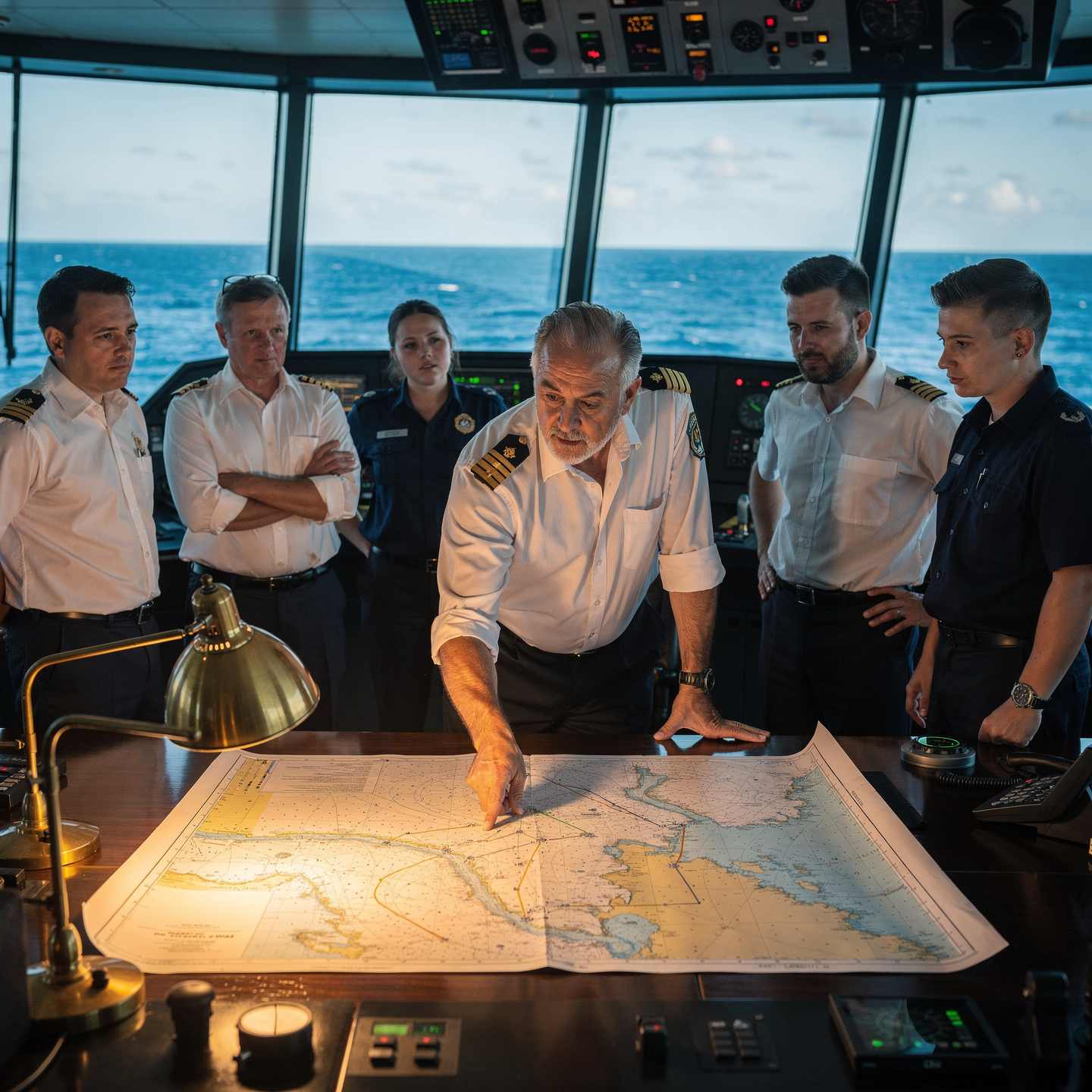
Optimize maritime navigation:
“Manage the route efficiently (fuel, time) and safely (weather, currents), adapting speed to conditions and complying with environmental regulations.”

Assess and mitigate maritime weather risks:
“Interpret weather forecasts and adapt the voyage plan, considering the vulnerability of the vessel and the cargo.”

Interpreting and applying maritime prediction models:
Analyze oceanographic and meteorological data to predict safe navigation conditions, optimizing routes and minimizing risks.

Accurately predict sea conditions:
Integrate meteorological, oceanographic and buoy data, validating models with direct observation and interpreting trends to anticipate significant changes.

Develop efficient navigation strategies:
Integrate meteorological and oceanographic information to optimize routes and anticipate adverse conditions.

Use simulation tools for decision-making:
“Evaluate scenarios considering economic, operational and safety factors, communicating clear and justified recommendations.”
Curriculum - Modules
- Comprehensive Maritime Incident Management: protocols, roles, and chain of command for coordinated response
- Operational Planning and Execution: briefing, routes, weather windows, and go/no-go criteria
- Rapid Risk Assessment: criticality matrix, scene control, and decision-making under pressure
- Operational Communication: VHF/GMDSS, standardized reports, and inter-agency liaison
- Tactical Mobility and Safe Boarding: RHIB maneuvers, approach, mooring, and recovery
- Equipment and Technologies: PPE, signaling, satellite tracking, and field data logging
- Immediate Care of the Affected: primary assessment, hypothermia, trauma, and stabilization for evacuation
- Adverse Environmental Conditions: swell, Visibility, flows, and operational mitigation
Simulation and training: critical scenarios, use of VR/AR, and exercises with performance metrics
Documentation and continuous improvement: lessons learned, indicators (MTTA/MTTR), and SOP updates
- Introduction to predictive modeling: basic concepts and applications in marine meteorology.
- Statistical analysis of marine meteorological data: time series, distributions, and correlations.
- Numerical weather prediction (NWP) models: fundamentals, components, and resolution.
- Operational oceanography: models of currents, waves, and sea surface temperature.
- Acquisition and processing of marine meteorological data: weather stations, buoys, and satellites.
- Machine learning techniques applied to marine weather forecasting: regression, classification, and neural networks.
- Validation and evaluation of predictive models: error, bias, and uncertainty metrics.
- Visualization and communication of results: maps, graphs, and tools Interactive.
- Practical applications of predictive modeling in maritime navigation: route optimization, safety, and efficiency.
- Case study: Predictive modeling of extreme events in the marine environment.
‘
- Introduction to Predictive Ocean Modeling: Scope and Applications
- Fundamentals of Physical Oceanography: Thermodynamics, Salinity, Density
- Waves: Linear Theory, Spectra, Significant Height, Period
- Wind-Generated Waves: Empirical and Parametric Models
- Ocean Currents: Wind Currents, Thermohaline Currents, Tidal Currents
- Numerical Models: Finite Difference, Finite Volume, Finite Element Models
- Implementation of Wave Propagation Models (SWAN, WAVEWATCH III)
- Assimilation of Observational Data: Buoys, Satellites, HF Radars
- Model Validation and Calibration: Error Metrics, Analysis sensitivity
- Practical applications: coastal forecasting, wave energy, maritime safety
‘
- Introduction to Predictive Modeling: Basic Concepts and Applications in Navigation
- Descriptive and Exploratory Statistics: Analysis of Navigation Data
- Linear and Nonlinear Regression: Predictive Models of Speed and Fuel Consumption
- Time Series: Modeling of Tides, Currents, and Weather Conditions
- Machine Learning: Classification and Regression Algorithms for Navigation
- Monte Carlo Simulation: Risk Assessment and Route Optimization
- Agent-Based Modeling: Simulation of Maritime Traffic and Vessel Behavior
- Integration of Heterogeneous Data: Combining AIS, Meteorological, and Cartographic Data
- Validation and Evaluation of Models: Performance metrics and sensitivity testing
Software tools for modeling and simulation: Python, R, MATLAB
‘
- Introduction to numerical modeling of waves and currents: basic concepts and applications.
- Linear (Airy) and nonlinear (Stokes, cnoidal) wave theory: characteristics, limitations, and applicability.
- Spectral wave models (SWAN, WAVEWATCH III): fundamentals, input and output parameters, calibration, and validation.
- Ocean and coastal current models: Navier-Stokes equations, approximations, and simplifications.
- Generation of computational meshes: mesh types, spatial and temporal resolution, stability and convergence considerations.
- Meteorological forcings: wind, atmospheric pressure, temperature, and their influence on modeling.
- Wave-current interaction: effects on wave propagation and transport of sediments and coastal structures.
- Modeling of extreme events: storms, hurricanes, tsunamis, and their impact on the coast.
- Results analysis and visualization: data interpretation, wave height maps, currents, and sediment transport.
- Applications of advanced modeling: design of marine structures, coastal management, and risk prediction.
‘
- System Architecture and Components: Structural design, materials, and subsystems (mechanical, electrical, electronic, and fluid) with selection and assembly criteria for marine environments
- Fundamentals and Principles of Operation: Physical and engineering foundations (thermodynamics, fluid mechanics, electricity, control, and materials) that explain performance and operating limits
- Safety and Environmental (SHE): Risk analysis, PPE, LOTO, hazardous atmospheres, spill and waste management, and emergency response plans
- Applicable Regulations and Standards: IMO/ISO/IEC requirements and local regulations;
- Conformance criteria, certification, and best practices for operation and maintenance
- Inspection, testing, and diagnostics: Visual/dimensional inspection, functional testing, data analysis, and predictive techniques (vibration, thermography, fluid analysis) to identify root causes
- Preventive and predictive maintenance: Hourly/cycle/seasonal plans, lubrication, adjustments, calibrations, consumable replacement, post-service verification, and operational reliability
- Instrumentation, tools, and metrology: Measuring and testing equipment, diagnostic software, calibration and traceability; selection criteria, safe use, and storage
- Onboard integration and interfaces: Mechanical, electrical, fluid, and data compatibility; Sealing and watertightness, EMC/EMI, corrosion protection, and interoperability testing.
Quality, acceptance testing, and commissioning: process and materials control, FAT/SAT, bench and sea trials, go/no-go criteria, and evidence documentation.
Technical documentation and integrated practice: logs, checklists, reports, and a complete case study (safety → diagnosis → intervention → verification → report) applicable to any system.
- Introduction to Oceanography: Disciplines, spatial and temporal scales.
- Fundamentals of Oceanographic Remote Sensing: Active and passive sensors, satellite image processing.
- Descriptive Statistical Analysis for Oceanographic Data: Measures of central tendency, dispersion, and distribution.
- Visualization of Oceanographic Data: Use of specialized software (e.g., Python, R) to create graphs and maps.
- Numerical Oceanographic Modeling: Introduction to hydrodynamic and wave models.
- Model Calibration and Validation: Use of observational data for model improvement.
- Analysis of Oceanographic Time Series: Decomposition, trends, and seasonal patterns.
- Modeling Predictive Modeling with Machine Learning: Regression, classification, and neural networks applied to oceanography.
Performance Evaluation of Predictive Models: Accuracy, recall, and F1-score metrics.
Applications of Data Analysis and Modeling in Coastal Management and Climate Change.
‘
Career opportunities
- Maritime Route Analyst: Route optimization, risk and cost minimization.
- Marine Condition Forecaster: Preparation of reports and alerts for safe navigation.
- Marine Meteorology Consultant: Advising companies in the maritime sector on weather conditions.
- Oceanography and Modeling Researcher: Development of more accurate and efficient prediction models.
- Port Planning Officer: Management of vessel entry and exit, optimizing logistics.
- Marine Renewable Energy Technician: Evaluation of the energy potential of waves and tides.
- Marine Emergency Response Specialist: Prediction of spill dispersion and support in rescue operations.
- Maritime Navigation Software Developer: Creating tools and applications for predicting routes and conditions.
“`
Admission requirements

Academic/professional profile:
Degree/Bachelor's degree in Nautical Science/Maritime Transport, Naval/Marine Engineering, or a related field; or proven professional experience in bridge/operations.

Language proficiency:
Recommended functional maritime English (SMCP) for simulations and technical materials.

Documentation:
Updated resume, copy of degree or seaman's book, ID card/passport, letter of motivation.

Technical requirements (for online):
Equipment with camera/microphone, stable connection, ≥ 24” monitor recommended for ECDIS/Radar-ARPA.
Admission process and dates

1. Online
application
(form + documents).

2. Academic review and interview
(profile/objectives/schedule compatibility).

3. Admission decision
(+ scholarship proposal if applicable).

4. Reservation of place
(deposit) and registration.

5. Induction
(access to campus, calendars, simulator guides).
Scholarships and grants
- Advanced Predictive Modeling: Master data analysis and machine learning techniques for accurate route prediction.
- Critical Marine Conditions: Learn to anticipate swells, currents, and winds for safe and efficient navigation.
- Specialized Software: Use cutting-edge tools for scenario simulation and route optimization.
- Real-World Case Studies: Apply your knowledge in case studies based on maritime challenges. real.
- Professional Certification: Earn a recognized diploma that validates your skills in the maritime industry.
Testimonials
This diploma program provided me with the necessary tools to significantly improve the accuracy of my maritime route predictions. I applied the acquired knowledge to the optimization of a container ship’s route, achieving a 12% reduction in transit time and an 8% reduction in fuel consumption, exceeding the shipping company’s expectations and contributing to a more efficient and sustainable operation.
This diploma program provided me with the necessary tools to develop a system for predicting optimized maritime routes, taking into account variables such as weather conditions and real-time traffic. I implemented this system in my company, achieving a 15% reduction in transit times and a 12% reduction in fuel consumption.
Thanks to the Diploma in Maritime Route and Condition Forecasting, I was able to optimize our fishing fleet’s routes, reducing fuel consumption by 12% and increasing catches by 8% in the last quarter. The accuracy in predicting sea conditions allowed us to avoid areas of rough weather, ensuring crew safety and operational efficiency.
This diploma provided me with the tools and knowledge necessary to develop a predictive model of ocean currents with 15% more accuracy than standard models, which I successfully implemented in my company, reducing navigation times and fuel consumption on our transatlantic routes.
Frequently asked questions
Optimize navigation safety and efficiency.
Yes. The itinerary includes ECDIS/Radar-ARPA/BRM with harbor, ocean, fog, storm, and SAR scenarios.
Online with live sessions; hybrid option for simulator/practical placements through agreements.
Maritime routes and conditions.
Recommended functional SMCP. We offer support materials for standard phraseology.
Yes, with a relevant degree or experience in maritime/port operations. The admissions interview will confirm suitability.
Optional (3–6 months) through Companies & Collaborations and the Alumni Network.
Simulator practice (rubrics), defeat plans, SOPs, checklists, micro-tests and applied TFM.
A degree from Navalis Magna University + operational portfolio (tracks, SOPs, reports and KPIs) useful for audits and employment.
- Introduction to Oceanography and Meteorology: Basic concepts and their relevance.
- Oceanographic Instrumentation: Types, calibration, and maintenance of sensors.
- Meteorological Data Acquisition: Weather stations, buoys, and satellites.
- Descriptive Statistical Analysis: Measures of central tendency and dispersion.
- Data Visualization: Tools and techniques for representing oceanographic and meteorological data.
- Data Quality Control: Identification and correction of errors.
- Oceanographic and Meteorological Databases: Structure and access to historical data.
- Time Series Analysis: Trends, seasonality, and cycles.
- Basic Predictive Modeling: Linear Regression and Other Techniques.
- Practical Applications: Case Studies and Real-World Examples.
‘
Request information
Complete the Application Form.
Attach your CV/degree certificate (if you have it to hand).
Indicate your preferred cohort (January/May/September) and whether you would like the hybrid option with simulator sessions.
An academic advisor will contact you within 24–48 hours to guide you through the admission process, scholarships, and compatibility with your professional schedule.
Faculty
Eng. Tomás Riera
Full Professor
Eng. Tomás Riera
Full Professor
Eng. Sofía Marquina
Full Professor
Eng. Sofía Marquina
Full Professor
Eng. Javier Bañuls
Full Professor
Eng. Javier Bañuls
Full Professor
Dr. Nuria Llobregat
Full Professor
Dr. Nuria Llobregat
Full Professor
Dr. Pau Ferrer
Full Professor
Dr. Pau Ferrer
Full Professor
Cap. Javier Abaroa (MCA)
Full Professor
Cap. Javier Abaroa (MCA)
Full Professor