Diploma in Digital Navigation Systems
Why this certificate program?
The Diploma in Digital Navigation Systems
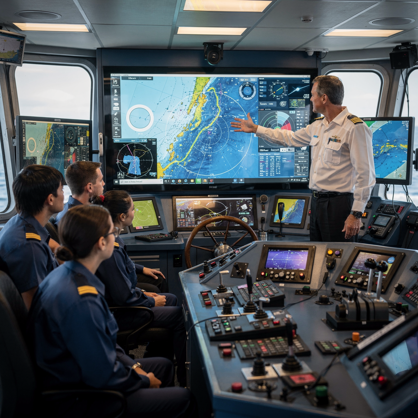
This program provides you with the knowledge and practical skills necessary to master cutting-edge navigation technologies. You will learn to integrate, configure, and operate modern ECDIS, GPS, AIS, and radar systems, optimizing navigational safety and efficiency. This program will prepare you to face the challenges of digital maritime navigation with confidence and competence.
Differential Advantages
- Software and Hardware Mastery: Comprehensive training in the most widely used navigation systems in the industry.
- Simulations and Practical Cases: Real-world application of acquired knowledge in simulated environments and real-world scenarios.
- Knowledge of Current Regulations: In-depth understanding of the regulations and international standards applicable to digital navigation.
- Route Optimization and Data Management: Skills to plan efficient routes, manage navigation information, and improve decision-making.
- Professional Certification: Recognition of your skills and knowledge in digital navigation systems.
- Modality: Online
- Level: Diplomado
- Hours: 800 H
- Start date: 01-10-2026
Availability: 1 in stock
Who is it aimed at?
- Deck officers and navigators seeking to master ECDIS, radar, AIS, and integrated systems for safe and efficient navigation.
- Bridge supervisors and captains who need to optimize digital information management and real-time decision-making.
- Shipping and fleet management personnel who wish to update their knowledge of the latest navigation technologies.
- Maritime industry professionals interested in understanding the impact of digitalization on navigation and maritime safety.
- Students and recent graduates of maritime fields seeking a specialization in digital navigation systems to boost their careers.
Flexibility and Applicability
Designed for active professionals: updated content, relevant case studies, and a focus on the real-world application of technologies on the bridge.
Objectives and competencies

Interpreting and applying information from electronic nautical charts:
“Use the information for planning and monitoring the journey, adjusting the route in real time according to weather and traffic conditions.”

Operate and maintain digital navigation equipment:
Interpret information from sensors and systems (AIS, radar, ECDIS) to support safe decision making.

Integrate and analyze data from multiple sensors for decision making.
“Identify significant patterns, anomalies, and trends in the integrated data, and communicate them effectively to support task planning and execution.”

Managing navigation safety and efficiency using digital systems:
Interpret sensor information (radar, AIS, GNSS) and electronic charts to optimize the route and proactively avoid hazards.
Solving problems and acting effectively in emergency situations:
Prioritize the safety of human life, the stability of the vessel and the protection of the environment, using standardized procedures and effective communication with the crew and competent authorities.

Comply with national and international maritime regulations regarding digital navigation:
“Use electronic navigation systems (ECDIS, AIS, GPS) in accordance with IMO standards and maritime administration guidelines, ensuring equipment updates and calibration, and documenting procedures according to ISM Code requirements.”
Curriculum - Modules
- Comprehensive Maritime Incident Management: protocols, roles, and chain of command for coordinated response
- Operational Planning and Execution: briefing, routes, weather windows, and go/no-go criteria
- Rapid Risk Assessment: criticality matrix, scene control, and decision-making under pressure
- Operational Communication: VHF/GMDSS, standardized reports, and inter-agency liaison
- Tactical Mobility and Safe Boarding: RHIB maneuvers, approach, mooring, and recovery
- Equipment and Technologies: PPE, signaling, satellite tracking, and field data logging
- Immediate Care of the Affected: primary assessment, hypothermia, trauma, and stabilization for evacuation
- Adverse Environmental Conditions: swell, Visibility, flows, and operational mitigation
Simulation and training: critical scenarios, use of VR/AR, and exercises with performance metrics
Documentation and continuous improvement: lessons learned, indicators (MTTA/MTTR), and SOP updates
- Introduction to Inertial Navigation Systems (INS) and Global Navigation Satellite Systems (GNSS)
- INS Operating Principles: Accelerometers, Gyroscopes, and Platforms
- GNSS Fundamentals: GPS, GLONASS, Galileo, BeiDou, and their Constellations
- Electronic Mapping: Data Formats, Standards (S-57, S-100), and Georeferencing
- INS/GNSS Integration: Kalman Filtering, Data Fusion, and Combined Advantages
- Reference Systems: Datum, Ellipsoids, Map Projections, and Coordinate Transformation
- Complementary Sensors: Odometers, Magnetometers, and Altimeters
- Errors and Calibration: Sources of error in INS and GNSS, calibration and mitigation techniques
- Applications: Maritime, air, and land navigation, mapping, and precision positioning
- Future Trends: Integration with artificial intelligence and new navigation systems
‘
- Introduction to ECDIS Systems: History, Regulations, and Standards
- ECDIS System Components: Hardware, Software, and Peripherals
- Electronic Navigational Charts (ENCs): Types, Formats, and Providers
- Installation and Configuration of ECDIS Systems: Best Practices
- Integration of Sensors and Equipment: Radar, AIS, GNSS, Gyrocompass
- Communications and Networks in ECDIS Systems: Protocols and Security
- Data Management and Updates in ECDIS: Procedures and Control
- System Security and Redundancy: Power Supply, Backups
- Diagnostics and Troubleshooting in ECDIS: Common faults
- Preventive and corrective maintenance of ECDIS systems
‘
- Introduction to Electronic Cartography: History, Standards, and Formats
- ECDIS Systems: Types, Components, Installation, and Configuration
- Electronic Charts: Types (ENC, RNC), Sources, Accuracy, and Scales
- Radar: Operating Principles, Types, Range, and Resolution
- ARPA: Target Acquisition, Tracking, and Calculation of Headings and Speeds
- Integration of ECDIS and Radar: Overlay, Correlation, and Alerts
- Navigation Sensors: GNSS, Gyro, Log, Echosounder, AIS
- Electronic Chart Corrections: Procedures, Sources, and Formats
- Alarm and Alert Management in ECDIS and Radar
- Legal and regulatory considerations: STCW, IMO and maritime authorities
‘
- Introduction to Electronic Charting: History and Evolution
- IMO Standards: S-52, S-57, S-63, IHO, and IEC
- Electronic Chart Formats: ENC, RNC, VPF
- ECDIS: Performance Requirements, Types, Approval
- AIS: Operation, Messages, Classes, Security
- Installation and Configuration of ECDIS and AIS
- Maintenance and Updating of Electronic Charts
- ECDIS-AIS Integration with Other Navigation Systems
- Legal and Regulatory Aspects of Electronic Charting
- Best Practices in the Use of ECDIS and AIS
‘
- System Architecture and Components: Structural design, materials, and subsystems (mechanical, electrical, electronic, and fluid) with selection and assembly criteria for marine environments
- Fundamentals and Principles of Operation: Physical and engineering foundations (thermodynamics, fluid mechanics, electricity, control, and materials) that explain performance and operating limits
- Safety and Environmental (SHE): Risk analysis, PPE, LOTO, hazardous atmospheres, spill and waste management, and emergency response plans
- Applicable Regulations and Standards: IMO/ISO/IEC requirements and local regulations;
- Conformance criteria, certification, and best practices for operation and maintenance
- Inspection, testing, and diagnostics: Visual/dimensional inspection, functional testing, data analysis, and predictive techniques (vibration, thermography, fluid analysis) to identify root causes
- Preventive and predictive maintenance: Hourly/cycle/seasonal plans, lubrication, adjustments, calibrations, consumable replacement, post-service verification, and operational reliability
- Instrumentation, tools, and metrology: Measuring and testing equipment, diagnostic software, calibration and traceability; selection criteria, safe use, and storage
- Onboard integration and interfaces: Mechanical, electrical, fluid, and data compatibility; Sealing and watertightness, EMC/EMI, corrosion protection, and interoperability testing.
Quality, acceptance testing, and commissioning: process and materials control, FAT/SAT, bench and sea trials, go/no-go criteria, and evidence documentation.
Technical documentation and integrated practice: logs, checklists, reports, and a complete case study (safety → diagnosis → intervention → verification → report) applicable to any system.
- Introduction to Electronic Cartography: Formats, Standards, and Updates
- ECDIS Systems: Types, Components, Performance Requirements, and IMO Regulations
- Electronic Charts: Types (ENC, RNC), Structure, Symbology, and Databases
- Radar: Operating Principles, Tuning, Interpretation, and Performance
- Integrating Sensors into ECDIS: GNSS, Gyro, Log, Echosounder, AIS
- Alarms and Warnings in ECDIS: Types, Priorities, and User Actions
- Visiting a Voyage in ECDIS: Establishing the Route, Turning Points, and Safety Zones
- Using Radar for Navigation and Collision Avoidance
- ARPA: Target acquisition and tracking, CPA/TCPA calculation, risk assessment
- Simulation and practical exercises with ECDIS and radar
‘
Career opportunities
- Digital Navigation Systems Design and Development Technician: Creation and improvement of software and hardware for navigation systems.
- Navigation Equipment Installer and Maintainer: Installation, configuration, and maintenance of navigation systems on ships and other platforms.
- Navigation Systems Consultant: Advising companies and organizations on the implementation and use of digital navigation systems.
- Digital Cartography Specialist: Creation, updating, and management of digital nautical charts and geospatial databases.
- Navigation Data Analyst: Processing and analysis of data generated by navigation systems to optimize routes and improve safety.
- Navigation Simulation Technician: Development and operation of navigation simulators for training and system testing.
- Sales and Support Representative Navigation Equipment Technician: Sales and technical support of digital navigation equipment.
Navigation Technology Researcher: Participation in research and development projects for new navigation technologies.
“`
Admission requirements

Academic/professional profile:
Degree/Bachelor's degree in Nautical Science/Maritime Transport, Naval/Marine Engineering, or a related field; or proven professional experience in bridge/operations.

Language proficiency:
Recommended functional maritime English (SMCP) for simulations and technical materials.

Documentation:
Updated resume, copy of degree or seaman's book, ID card/passport, letter of motivation.

Technical requirements (for online):
Equipment with camera/microphone, stable connection, ≥ 24” monitor recommended for ECDIS/Radar-ARPA.
Admission process and dates

1. Online
application
(form + documents).

2. Academic review and interview
(profile/objectives/schedule compatibility).

3. Admission decision
(+ scholarship proposal if applicable).

4. Reservation of place
(deposit) and registration.

5. Induction
(access to campus, calendars, simulator guides).
Scholarships and grants
- Master the Navigation of the Future: Delve into ECDIS systems, radars, and GPS, optimizing safety and efficiency in maritime navigation.
- Professional Development: Stay up-to-date with the latest technologies and regulations in digital navigation, boosting your career in the industry.
- Hands-on Simulation: Apply your knowledge in state-of-the-art navigation simulators, facing realistic scenarios and honing your skills.
- Professional Certification: Earn a recognized diploma that validates your competencies in digital navigation systems for employers and maritime authorities.
- Expert Instructors: Learn from professionals with extensive experience in navigation and technology, receiving high-level training quality.
Testimonials
This diploma program exceeded my expectations. I acquired solid knowledge in digital cartography, GPS, GIS, and remote sensing, allowing me to lead the development of a mobile navigation application for hiking that has been downloaded more than 10,000 times and has excellent user reviews.
The Diploma in Onboard Communications & Technology exceeded my expectations. I gained a solid practical understanding of communication systems and emerging technologies in the industry, enabling me to lead the implementation of a new connectivity system in my company, optimizing operational efficiency and customer satisfaction.
This diploma program exceeded my expectations. I acquired solid knowledge in digital cartography, GPS, GIS, and other geospatial tools, which allowed me to lead the development of a navigation application for our company, optimizing delivery routes and significantly reducing costs.
This diploma provided me with the necessary tools and knowledge to develop a navigation application for mobile devices, which was successfully implemented in a logistics company, optimizing its delivery routes and reducing operating costs by 15%.

Frequently asked questions
Digital navigation systems, including GPS, GLONASS, Galileo, and other positioning and navigation systems.
Yes. The itinerary includes ECDIS/Radar-ARPA/BRM with harbor, ocean, fog, storm, and SAR scenarios.
Online with live sessions; hybrid option for simulator/practical placements through agreements.
It depends on the specific diploma program, but it generally covers a combination of land, sea, and air systems.
Recommended functional SMCP. We offer support materials for standard phraseology.
Yes, with a relevant degree or experience in maritime/port operations. The admissions interview will confirm suitability.
Optional (3–6 months) through Companies & Collaborations and the Alumni Network.
Simulator practice (rubrics), defeat plans, SOPs, checklists, micro-tests and applied TFM.
A degree from Navalis Magna University + operational portfolio (tracks, SOPs, reports and KPIs) useful for audits and employment.
- Introduction to Electronic Cartography: History, Evolution, and Regulations
- Reference Systems: Datum, Map Projections, and Time Zones
- Electronic Nautical Charts (ENC): S-57 and S-63 Standards and Formats
- ECDIS: IMO Requirements, Performance Standards, and Types
- Aids to Navigation: Buoys, Beacons, Lighthouses, and Fog Signals
- Chart Corrections and Updates: Services, Methods, and Frequency
- Data Integration: Radar, AIS, GPS, and Other Sensors
- Route Planning in ECDIS: Waypoints, Alarms, and Safety Parameters
- Monitoring the Navigation: Position tracking, alarms, and alerts
Information management: Organization, storage, and retrieval of map data
‘
Request information
Complete the Application Form.
Attach your CV/degree certificate (if you have it to hand).
Indicate your preferred cohort (January/May/September) and whether you would like the hybrid option with simulator sessions.
An academic advisor will contact you within 24–48 hours to guide you through the admission process, scholarships, and compatibility with your professional schedule.
Faculty
Eng. Tomás Riera
Full Professor
Eng. Tomás Riera
Full Professor
Eng. Sofía Marquina
Full Professor
Eng. Sofía Marquina
Full Professor
Eng. Javier Bañuls
Full Professor
Eng. Javier Bañuls
Full Professor
Dr. Nuria Llobregat
Full Professor
Dr. Nuria Llobregat
Full Professor
Dr. Pau Ferrer
Full Professor
Dr. Pau Ferrer
Full Professor
Cap. Javier Abaroa (MCA)
Full Professor
Cap. Javier Abaroa (MCA)
Full Professor