Diploma in Navigation Electronics (GPS, Radar, Sonar)
Why this certificate program?
The Diploma in Navigation Electronics (GPS, Radar, Sonar)
This program provides you with a comprehensive understanding of the electronic systems essential for modern navigation. Learn to interpret GPS data for precise location, master the operation of radar for obstacle detection, and use sonar for underwater exploration. This program prepares you for the installation, configuration, and maintenance of this equipment, ensuring safe and efficient navigation.
Differential Advantages
- In-depth Knowledge: Gain a theoretical and practical understanding of the principles behind each system.
- Practical Applications: Learn to troubleshoot common problems and optimize equipment performance.
- Technical Skills: Develop the ability to perform basic calibrations, adjustments, and repairs.
- Continuous Updates: Stay up-to-date with the latest technologies and trends in navigation electronics.
- Professional Certification: Validate your knowledge and improve your job opportunities in the maritime sector.
- Modality: Online
- Level: Diplomado
- Hours: 800 H
- Start date: 11-06-2026
Availability: 1 in stock
Who is it aimed at?
- Bridge officers and marine electronics technicians seeking to master electronic navigation systems and optimize navigational safety and efficiency.
- Maintenance technicians and naval engineers wishing to deepen their knowledge of the diagnosis and repair of GPS, radar, and sonar equipment, complying with current regulations.
- Fishing and oceanographic research professionals needing to maximize the use of sonar technology for underwater detection and analysis.
- Maritime inspectors and naval experts interested in updating their knowledge of the latest technologies and inspection procedures in navigation electronics.
- Students of electronic and nautical engineering seeking a practical specialization focused on the application of electronics in the field. Maritime.
Study Flexibility:
Adapted to working professionals: live and recorded online classes, 24/7 access to learning materials and personalized tutoring.
Objectives and competencies

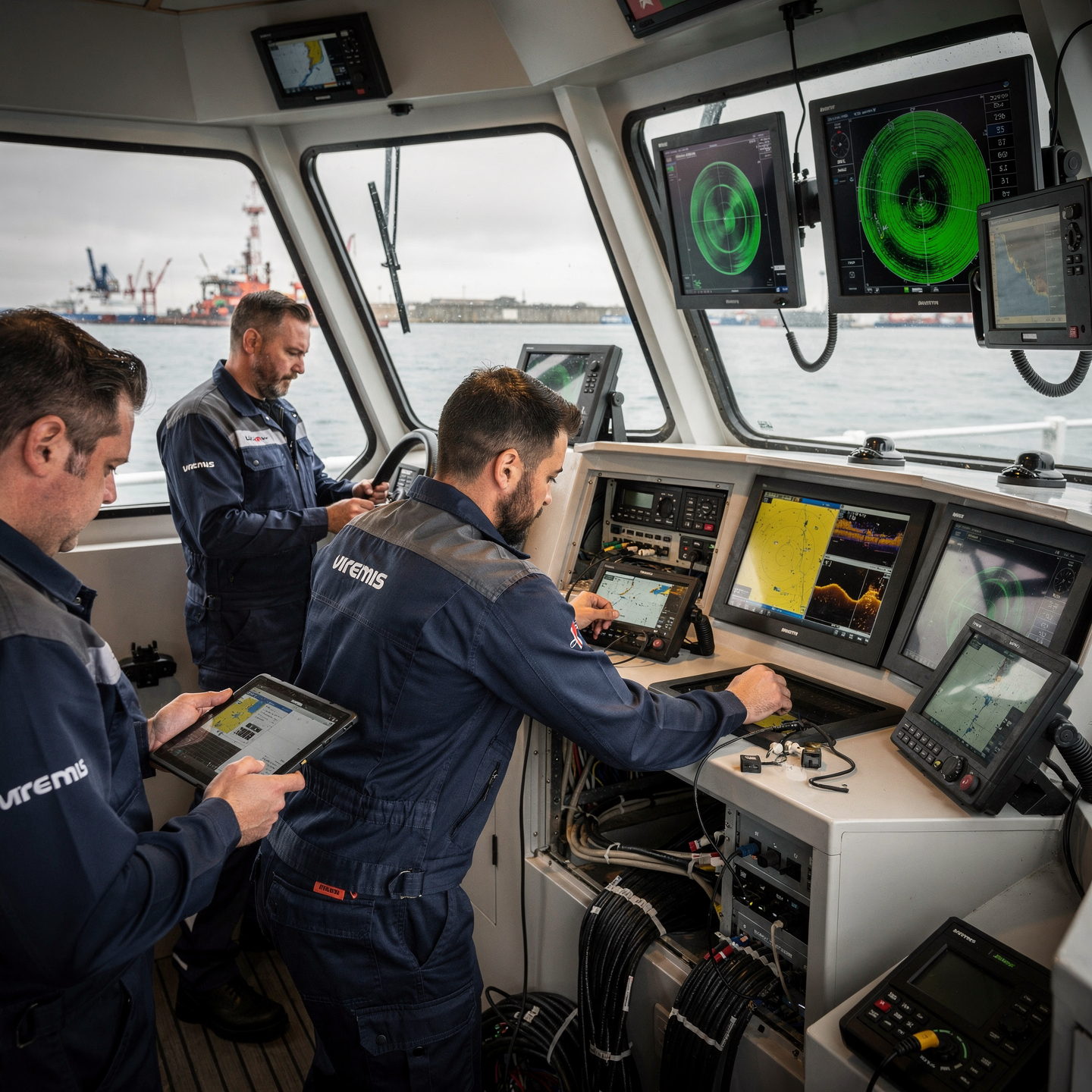
Interpreting and analyzing navigation sensor data:
Integrate data from multiple sources (AIS, radar, ECDIS) to build a complete picture of the situation and anticipate risks.

Diagnosing and repairing faults in navigation equipment:
“Identify the source of the failure through systematic testing, using technical manuals and specialized diagnostic tools.”

Operate and maintain electronic navigation systems:
Interpret information from sensors and equipment accurately, managing uncertainty and applying necessary corrections.

Integrate navigation systems to optimize operational efficiency:
Analyze navigation data (AIS, radar, ECDIS) to optimize routes, minimize risks and reduce fuel consumption, communicating the decisions to the bridge.

Adapting and applying emerging technologies in electronic navigation:
Integrate data from advanced sensors (GNSS, AIS, radars) for accurate situational awareness and to make informed decisions under diverse conditions.

Manage the information obtained for strategic decision-making:
Analyze market data, competition, and emerging trends to identify opportunities and threats, translating them into concrete and measurable action plans.
Curriculum - Modules
- Comprehensive Maritime Incident Management: protocols, roles, and chain of command for coordinated response
- Operational Planning and Execution: briefing, routes, weather windows, and go/no-go criteria
- Rapid Risk Assessment: criticality matrix, scene control, and decision-making under pressure
- Operational Communication: VHF/GMDSS, standardized reports, and inter-agency liaison
- Tactical Mobility and Safe Boarding: RHIB maneuvers, approach, mooring, and recovery
- Equipment and Technologies: PPE, signaling, satellite tracking, and field data logging
- Immediate Care of the Affected: primary assessment, hypothermia, trauma, and stabilization for evacuation
- Adverse Environmental Conditions: swell, Visibility, flows, and operational mitigation
Simulation and training: critical scenarios, use of VR/AR, and exercises with performance metrics
Documentation and continuous improvement: lessons learned, indicators (MTTA/MTTR), and SOP updates
- Introduction to Navigation Systems: History, Evolution, and Types
- Fundamentals of Geodesy and Reference Systems: Datum, Ellipsoids, Map Projections
- Global Positioning Systems (GNSS): GPS, GLONASS, Galileo, BeiDou – Principles and Operation
- Navigation Sensors: Gyroscopes, Accelerometers, Magnetometers, Odometers – Principles and Applications
- Units of Measurement and Conversions: Degrees, Minutes, Seconds, Nautical, Imperial, and Metric Units
- Inertial Navigation Systems (INS): Principles, Operation, Errors, and Calibration
- Navigation System Integration: Kalman Filtering, Sensor Fusion, and Redundancy
- Assisted Navigation Systems: DGNSS, SBAS, GBAS – principles and applications.
- Digital Cartography: formats, data structures, georeferencing, and visualization.
- Practical applications of navigation systems: autonomous vehicles, robotics, aviation, maritime, and land navigation.
‘
- Introduction to Electronic Navigation Systems (ENS): Evolution and Current Landscape
- Fundamentals of Electronics: Components, Basic Circuits, and Signals
- Navigation Sensors: Types, Operating Principles, and Characteristics
- Global Positioning Systems (GNSS): GPS, GLONASS, Galileo, BeiDou
- Inertial Navigation Systems (INS): Accelerometers, Gyroscopes, and Inertial Platforms
- Navigation Aid Systems (NAVAIDS): Radio Beacons, VOR, DME, ILS
- Radar and ARPA: Operating Principles, Types, and Applications
- Automatic Identification Systems (AIS): Principles, Messages, and Applications
- Maritime Communications: VHF, MF/HF, satellite (Inmarsat, Iridium)
- Systems Integration: Electronic Navigation Systems Architecture
‘
- Introduction to Electronic Navigation Systems (ENS): evolution, benefits, and limitations
- Fundamentals of Electronics: components, basic circuits, analog and digital signals
- Navigation Sensors: gyroscopes, accelerometers, magnetometers, pressure and temperature sensors
- Global Positioning Systems (GNSS): GPS, GLONASS, Galileo, BeiDou; Principles, Errors, and Accuracies
Inertial Navigation Systems (INS): Operating principles, advantages, and disadvantages
Navigation Aids Systems: Radio beacons, Automatic Identification Systems (AIS), radars
Data Integration: Kalman filters, sensor fusion, redundancy, and reliability
Maritime Communications: VHF/HF/MF radio communications, Digital Selective Calling (DSC) systems, satellite communications
Data Visualization: Navigation displays, human-machine interfaces, ergonomics
Future Trends: Autonomous navigation, artificial intelligence in navigation, quantum navigation systems
- Introduction to Positioning and Detection Systems: GPS, Radar, and Sonar
- GPS Fundamentals: Constellations, Signals, Receivers, and Accuracy
- Radar Principles: Wave Propagation, Types of Radar, Components
- Sonar Operation: Acoustic Waves, Types of Sonar, Applications
- Errors and Sources of Error in GPS, Radar, and Sonar
- Coordinate Systems and Geodetic Datums
- Electronic Cartography and its Integration with GPS, Radar, and Sonar
- Maritime Applications of GPS: Navigation, Positioning, and Safety
- Radar Applications: Object Detection, Navigation in Reduced Visibility, Control of traffic
- Sonar Applications: bathymetry, underwater detection, underwater communication
‘
- System Architecture and Components: Structural design, materials, and subsystems (mechanical, electrical, electronic, and fluid) with selection and assembly criteria for marine environments
- Fundamentals and Principles of Operation: Physical and engineering foundations (thermodynamics, fluid mechanics, electricity, control, and materials) that explain performance and operating limits
- Safety and Environmental (SHE): Risk analysis, PPE, LOTO, hazardous atmospheres, spill and waste management, and emergency response plans
- Applicable Regulations and Standards: IMO/ISO/IEC requirements and local regulations;
- Conformance criteria, certification, and best practices for operation and maintenance
- Inspection, testing, and diagnostics: Visual/dimensional inspection, functional testing, data analysis, and predictive techniques (vibration, thermography, fluid analysis) to identify root causes
- Preventive and predictive maintenance: Hourly/cycle/seasonal plans, lubrication, adjustments, calibrations, consumable replacement, post-service verification, and operational reliability
- Instrumentation, tools, and metrology: Measuring and testing equipment, diagnostic software, calibration and traceability; selection criteria, safe use, and storage
- Onboard integration and interfaces: Mechanical, electrical, fluid, and data compatibility; Sealing and watertightness, EMC/EMI, corrosion protection, and interoperability testing.
Quality, acceptance testing, and commissioning: process and materials control, FAT/SAT, bench and sea trials, go/no-go criteria, and evidence documentation.
Technical documentation and integrated practice: logs, checklists, reports, and a complete case study (safety → diagnosis → intervention → verification → report) applicable to any system.
- Introduction to Positioning and Navigation Systems: Evolution and Applications
- Fundamentals of Radio Navigation: Waves, Propagation, Errors
- Global Positioning Systems (GNSS): GPS, GLONASS, Galileo, BeiDou
- Internal Operation of GPS: Signals, Constellation, Accuracies
- Differential Positioning Systems (DGPS): Corrections, Base Stations
- Inertial Navigation Systems (INS): Accelerometers, Gyroscopes, Integration
- Sensor Integration: Fusion of GNSS, INS, Odometer, and Altimeter Data
- Signal Processing and Filtering: Kalman, Smoothing
- Systems Electronic navigational charts: ECDIS, ECS, digital nautical charts
Error analysis and mitigation: accuracy, availability, integrity
‘
Career opportunities
- Maintenance and Installation Technician for navigation equipment (GPS, Radar, Sonar) on ships.
- Onboard Electronics Technician: responsible for the correct operation and repair of electronic navigation systems.
- Technician in Nautical Service Companies: calibration, repair, and certification of equipment.
- Technical Consultant: advising on the selection and installation of navigation equipment for vessels.
- Technical Sales: marketing electronic navigation equipment to companies in the sector.
- Software and Hardware Development: participation in R&D projects for new navigation equipment.
- Technical Training: instructor at nautical training centers, specializing in navigation electronics.
- Court Expert: preparation of reports Technicians specializing in maritime accidents related to navigation equipment.
“`
Admission requirements

Academic/professional profile:
Degree/Bachelor's degree in Nautical Science/Maritime Transport, Naval/Marine Engineering, or a related field; or proven professional experience in bridge/operations.

Language proficiency:
Recommended functional maritime English (SMCP) for simulations and technical materials.

Documentation:
Updated resume, copy of degree or seaman's book, ID card/passport, letter of motivation.

Technical requirements (for online):
Equipment with camera/microphone, stable connection, ≥ 24” monitor recommended for ECDIS/Radar-ARPA.
Admission process and dates

1. Online
application
(form + documents).

2. Academic review and interview
(profile/objectives/schedule compatibility).

3. Admission decision
(+ scholarship proposal if applicable).

4. Reservation of place
(deposit) and registration.

5. Induction
(access to campus, calendars, simulator guides).
Scholarships and grants
- Master Maritime Electronics: Delve into the operation and maintenance of GPS, Radar, and Sonar, essential equipment for safe navigation.
- Learn from Experts: Hands-on instruction provided by professionals with extensive experience in the naval industry.
- Professional Certification: Earn a recognized diploma that validates your knowledge and skills in navigation electronics.
- Immediate Application: Acquire the necessary tools to diagnose, repair, and optimize electronic systems on vessels of all types.
- Boost Your Career: Advance your professional career in the maritime sector with specialized and highly relevant knowledge sued.
Testimonials
“This diploma program exceeded my expectations. I acquired solid theoretical and practical knowledge in GPS, radar, and sonar, which allowed me to successfully lead the implementation of a new navigation system in my company, optimizing our routes and significantly reducing operating costs.”
During my diploma program in Electricity & Electronics, I exceeded my expectations by designing and building an automated control system for a greenhouse, integrating sensors, microcontrollers, and actuators. The project demonstrated my mastery of the concepts learned and my ability to apply them to practical solutions.
“This diploma program exceeded my expectations. I acquired solid theoretical and practical knowledge in GPS, radar, and sonar, which I immediately applied to my work, optimizing the navigation and safety of our fishing fleet. The hands-on practice with simulators and real equipment was key to my professional development.”
This diploma program exceeded my expectations. I acquired solid theoretical and practical knowledge in GPS, radar, and sonar, including data interpretation and equipment maintenance. I was able to immediately apply what I learned to my work, optimizing navigation and safety in my sector.
Frequently asked questions
Yes. The itinerary includes ECDIS/Radar-ARPA/BRM with harbor, ocean, fog, storm, and SAR scenarios.
Online with live sessions; hybrid option for simulator/practical placements through agreements.
GPS, radar and sonar.
Recommended functional SMCP. We offer support materials for standard phraseology.
Yes, with a relevant degree or experience in maritime/port operations. The admissions interview will confirm suitability.
Optional (3–6 months) through Companies & Collaborations and the Alumni Network.
Simulator practice (rubrics), defeat plans, SOPs, checklists, micro-tests and applied TFM.
A degree from Navalis Magna University + operational portfolio (tracks, SOPs, reports and KPIs) useful for audits and employment.
- Introduction to GNSS Systems: GPS, GLONASS, Galileo, BeiDou
- Fundamentals of Cartography: projections, datum, scales
- GNSS Receivers: operation, accuracy, errors, and mitigation
- Electronic Nautical Charts (ENC): S-57 standard and formats
- ECDIS: components, configuration, and information display
- Datum and transformations: implications for accurate navigation
- Basic Geodesy: Earth’s shape, ellipsoids, and geoid
- Reference Systems: WGS84, ITRF, and their application in GNSS
- Chart updates
electronics: methods and frequencies
Integration of GNSS and ECDIS with other navigation sensors
‘
Request information
Complete the Application Form.
Attach your CV/degree certificate (if you have it to hand).
Indicate your preferred cohort (January/May/September) and whether you would like the hybrid option with simulator sessions.
An academic advisor will contact you within 24–48 hours to guide you through the admission process, scholarships, and compatibility with your professional schedule.
Faculty
Eng. Tomás Riera
Full Professor
Eng. Tomás Riera
Full Professor
Eng. Sofía Marquina
Full Professor
Eng. Sofía Marquina
Full Professor
Eng. Javier Bañuls
Full Professor
Eng. Javier Bañuls
Full Professor
Dr. Nuria Llobregat
Full Professor
Dr. Nuria Llobregat
Full Professor
Dr. Pau Ferrer
Full Professor
Dr. Pau Ferrer
Full Professor
Cap. Javier Abaroa (MCA)
Full Professor
Cap. Javier Abaroa (MCA)
Full Professor