Master’s Degree in Climatology and Weather Forecasting with Satellites
Why this master’s programme?
The Master’s in Climatology and Weather Forecasting with Satellites
This program provides you with a in-depth understanding of climate processes and forecasting techniques, with a specialized focus on the use of satellite data. You will learn to analyze and interpret information obtained from satellites to model the climate, predict weather patterns, and understand the impact of climate change. This program prepares you to meet the challenges of climate analysis and weather forecasting using cutting-edge tools.
Differential Advantages
- Advanced Satellite Data Analysis: Master processing and interpretation techniques for climate and meteorological applications.
- Cutting-Edge Climate Modeling: Use numerical models to simulate climate and predict future scenarios.
- Accurate Weather Forecasting: Apply advanced techniques to improve the accuracy of short-, medium-, and long-term predictions.
- Climatology and Remote Sensing Experts: Learn from leading professionals in the field and participate in innovative research projects.
- Practical Applications: Develop real-world projects for sectors such as agriculture, energy, and natural disaster management.
- Modality: Online
- Level: Masters
- Hours: 1600 H
- Start date: 26-04-2026
Availability: 1 in stock
Who is it aimed at?
- Graduates in Physics, Environmental Science, Geography, or Engineering who wish to specialize in climate analysis and weather forecasting using satellite technology.
- Meteorology and climatology professionals seeking to update their knowledge and skills in using satellite data to improve climate predictions and models.
- Researchers and academics interested in deepening their study of climate change and its impacts through satellite data analysis.
- Environmental consultants and company technicians who need to interpret and apply meteorological and climate information for decision-making in sectors such as agriculture, energy, or risk management.
- Natural resource management and land-use planning managers who require accurate and up-to-date climate and weather information for sustainable land management.
Flexibility and Practical Application
Designed for professionals and students: flexible online format, practical case studies with real data, and direct application in projects and research.
Objectives and skills

Develop advanced predictive models:
“Using Machine Learning algorithms (Regression, Classification, Neural Networks) to forecast demand, optimize inventory, and predict credit risk.”

Interpreting satellite data to optimize water resource management:
“Analyze spectral and geospatial information to assess water availability, quality and use, identifying patterns and anomalies for informed decision-making.”

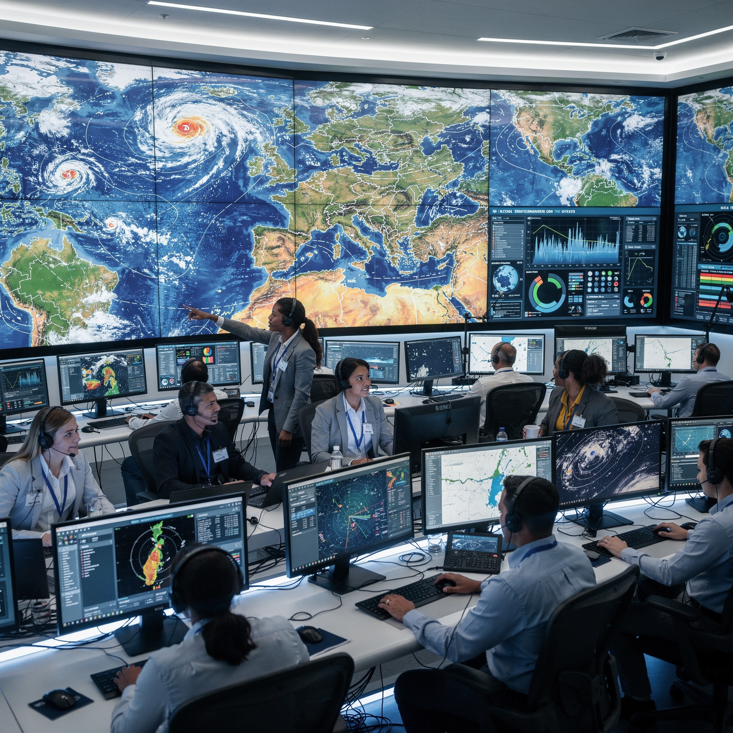
Assessing the impact of climate change on regional weather patterns:
Analyze historical data and predictive models to identify trends in temperature, precipitation, and extreme events, considering the vulnerability of ecosystems and local communities.

Designing mitigation strategies for extreme weather events:
“Assess specific risks by type of event (waves, wind, ice) and adapt navigation/cargo plans.”

Effectively communicate climate and weather information to diverse audiences:
Adapt the language and format of the information, considering the level of knowledge and the specific needs of each audience (citizens, companies, media, etc.).

Lead climate and meteorological research projects using satellite technology:
“Design, execute and communicate robust studies, ensuring the quality of satellite data and its integration with climate models, collaborating with experts and managing resources efficiently.”
Study plan – Modules
- Fundamentals of satellite observation: types of passive and active sensors, spectral bands, and spatial, temporal, and radiometric resolution
- Advanced satellite image processing: radiometric and geometric correction, multisensor data fusion, and spatial interpolation
- Methods for extracting climate variables: sea surface temperature, atmospheric humidity, aerosol concentration, and solar radiation
- Integration of satellite data into numerical climate models: data assimilation techniques and computational optimization
- Artificial intelligence algorithms applied to climate classification and prediction based on satellite time series
- Interpretation of satellite-derived climate indices: ENSO, NAO, AO, and their impact on predictive modeling
- Detection and analysis of extreme events using satellite data: cyclones, heat waves, droughts, and floods
Methodologies for the dynamic monitoring of atmospheric and oceanic variability using state-of-the-art satellite sensors
Development of standard protocols for validation and cross-calibration of satellite products against in-situ data
Practical applications: integration of satellite information into operational early warning systems and strategic climate decision-making
- Fundamentals of multispectral remote sensing: physical and technological principles of satellite sensors
- Spectral characterization of the atmosphere and land surfaces: radiative interaction and atmospheric effects
- Radiometric and geometric processing of satellite images: calibration, atmospheric correction, and orthorectification
- Advanced algorithms for multispectral information extraction: supervised and unsupervised classification, and machine learning
- Generation and validation of key spectral indices for climate monitoring: NDVI, EVI, albedo, surface humidity, and brightness temperature
- Integration of multispectral data into numerical climate models: fusion and assimilation strategies for satellite data
- Applications in advanced weather forecasting: improvement of seasonal prediction models and early warnings
- Climate trend analysis using multispectral time series: change detection and statistical modeling
- Use of cloud processing platforms and big data tools for efficient management of large volumes of satellite imagery
- Case studies and practical projects: real-world application of multispectral analysis in regional and global climate variability scenarios
- Fundamentals of Multispectral Satellite Sensors: Design, Physical Principles, and Technical Characteristics of Passive and Active Instruments in Orbit
- Radiometric Processing and Calibration: Atmospheric Correction Techniques, Absolute and Relative Calibration to Ensure Accuracy in Spectral Data Capture
- Advanced Remote Sensing: Extraction and Analysis of Meteorological and Climatological Variables from Multispectral and Hyperspectral Images
- Spectral Interpretation: Identification and Discrimination of Specific Signatures for the Detection of Atmospheric Phenomena, such as Convective Clouds, Aerosols, and Water Vapor
- Satellite-Assisted Dynamic Modeling: Integration of Multispectral Data into High-Resolution Numerical Weather Prediction Models
- Data Fusion Algorithms: Synergistic Combination of Satellite Time Series with In-Situ Observations and Statistical Models for
- Improving predictive accuracy
Practical applications in climatology: monitoring climate patterns at regional and global scales, tracking extreme events and interannual variability
Use of artificial intelligence and machine learning in classification and prediction based on large volumes of satellite multispectral data
Uncertainty assessment and validation: methodologies for comparing predictions with observational data and continuously adjusting prediction models
Advanced case studies: detailed analysis of significant meteorological events using innovative multispectral interpretation techniques, highlighting their application in early warning systems and environmental management
- Fundamentals of satellite data assimilation: least squares principle, variational methods (3D-Var, 4D-Var), and extended Kalman filters for atmospheric prediction
- Technical and operational characteristics of multispectral satellite platforms: geosynchronous, polar, and microsatellites for climate monitoring
- Satellite data processing and pretreatment: radiometric calibration, atmospheric correction, and advanced spatial reprojection
- Advanced sensor fusion techniques: synergistic integration of radiometry, SAR radar, and hyperspectral sensors for improved temporal and spatial resolution
- Incorporation of satellite data into numerical models: strategies for direct coupling, parameter tuning, and improvement of simulated atmospheric dynamics
- Development and optimization of operational systems for Climate prediction: modular architecture, real-time integration, and workflow automation
Ensembles in climate prediction: design, generation, and calibration of perturbed ensembles for probabilistic uncertainty quantification
Satellite-based meteorological nowcasting: algorithms for detecting convective structures, temporal tracking, and dynamic extrapolation
Quantification and modeling of uncertainties: sources, propagation, and statistical methods for confidence assessment in predictions
Case studies and practical application: integration into national and international early warning systems and decision-making based on fused satellite data
- Theoretical Foundations of Atmospheric and Oceanographic Dynamics for Regional Climate Models
- Principles and Advanced Techniques of Remote Sensing: Meteorological Satellites, Radiometers, Spectrometers, and LiDAR
- Satellite Data Processing and Analysis: Atmospheric Correction, Radiometric Calibration, and Multisensor Fusion
- Dynamic and Statistical Downscaling Methodologies for Climate Regionalization
- Integration of Machine Learning Techniques in Climate Models: Convolutional Neural Networks, Decision Trees, and Deep Learning
- Development and Validation of Dynamic Regional Weather Prediction Models Based on Satellite Data
- Application of Artificial Intelligence Algorithms for Extreme Event Prediction and Climate Trend Analysis
- Frameworks and Computational Platforms for Advanced Climate Simulation: Use of HPC, Cloud Computing, and Python/R for modeling
- Uncertainty assessment and statistical verification in regional climate models using ensemble and cross-validation techniques
- Practical case studies: predicting heat waves, extreme precipitation events, and atmospheric anomalies by combining remote sensing and machine learning
- Impact of climate variability at a regional scale on socioeconomic sectors: agriculture, water resources, and disaster management
- Protocols for integrating satellite data with in-situ observations and conventional numerical models
- Ethics, transparency, and reproducibility in climate modeling: best practices in documentation and open source
- Fundamentals and principles of satellite remote sensing: types of sensors, spectral bands, and spatial-temporal resolution
- Satellite data preparation and preprocessing: radiometric correction, georeferencing, and noise filtering
- Integration of multisensor satellite images: optical, microwave, and radar for multifaceted climate analysis
- Advanced algorithms for merging satellite and terrestrial data to improve the accuracy of predictive models
- Applications of machine learning and neural networks in the interpretation and assimilation of satellite data
- Physical-statistical modeling of climate variables from satellite data: temperature, humidity, precipitation, and wind
- Cross-calibration and validation with meteorological stations and terrestrial observatories to ensure the reliability of predictions
- System implementation
- Data assimilation for high-resolution numerical weather prediction models
- Efficient management and storage strategies for large volumes of satellite data for real-time processing
- Case studies and impact studies: extreme event prediction, atmospheric phenomenon monitoring, and regional climate assessment
- Fundamentals of satellite remote sensing: physical principles, sensor types, and orbital platforms
- Advanced satellite image preprocessing techniques: radiometric calibration, atmospheric correction, and georeferencing
- Multisensor integration: fusion of optical, infrared, microwave, and lidar data for detailed atmospheric analysis
- Algorithms for extracting climate variables: surface temperature, humidity, vegetation index, and solar radiation
- High-resolution modeling: statistical and dynamic downscaling applied to local weather forecasts
- Application of machine learning and neural networks for advanced forecasting using satellite data
- Model validation and evaluation: statistical metrics, uncertainty analysis, and benchmarking with in-situ data
- Interpretation of global and regional climate patterns through multiscale time series analysis Satellite-based data.
Development and management of satellite databases for climatology: storage, access, and normalization of massive datasets.
Practical case studies: monitoring of extreme weather events, tracking of tropical cyclones, and analysis of long-term climate trends.
[…]
- Theoretical and mathematical foundations of remote sensing: electromagnetic principles, radiative interaction with the atmosphere and the Earth’s surface
- Design and structure of algorithms for satellite sensors: optical, microwave, and SAR radar applied to meteorology
- Computational optimization of algorithms: noise reduction techniques, improvement of spatial-temporal resolution, and efficiency in real-time processing
- Integration of multisensor and multisource data for climate monitoring: fusion of satellite data, ground stations, and atmospheric numerical models
- Statistical and dynamic validation of algorithms: cross-checking methods, uncertainty analysis, and continuous calibration with real-world events
- Real-time detection and monitoring of extreme weather events: cyclones, convective storms, heat waves, and heavy rainfall using advanced machine learning techniques
- Evaluation of global climate trends from time series Satellite weather patterns: decomposition methods, signal detection, and multiscale variability analysis
Implementation of operational platforms for continuous monitoring: architecture, data flows, latencies, and automated early warnings
Case studies and practical applications: analysis of recent events and the contribution of algorithms to emergency decision-making and advance planning
Future perspectives and technological challenges in the continuous improvement of remote sensing algorithms for meteorology and climatology
- Fundamentals of multispectral satellite sensors: launch, orbits, spatial and spectral resolution
- Advanced radiometric calibration and atmospheric correction techniques for satellite data
- Digital processing of multispectral images: filtering, enhancement, and data segmentation techniques
- Integration of machine learning algorithms and convolutional neural networks for spectral classification
- Physical and statistical models for extracting climate variables from multispectral satellite data
- Development and validation of derived products: vegetation indices, soil moisture, surface temperature, and cloud cover
- Multisensor and multispectral data fusion to improve coverage and temporal resolution in weather forecasting
- Implementation of multivariate and time series analysis techniques for anomaly detection
- Use of Geographic Information Systems (GIS) and big data platforms for the management and visualization of satellite climate data
- Optimization of climate prediction models through near real-time satellite data assimilation
- Development of high-precision weather forecasts based on advanced artificial intelligence techniques and PSMS data processing
- Applied case studies: analysis of extreme atmospheric phenomena using multispectral imagery
- Evaluation of uncertainties and improvements in climate models based on satellite data
- Practical applications in operational climatology, environmental management, and meteorological risk mitigation
- Future perspectives on emerging satellite sensors and their impact on the evolution of climate prediction models
climate
- Fundamentals of satellite remote sensing applied to climatology: physical principles, sensor types, orbits, and spatial-temporal resolution
- Advanced satellite image processing: radiometric calibration, atmospheric correction, multisensor data fusion, and noise filtering
- Multispectral and thermal interpretation for the identification of meteorological systems and climatic phenomena
- Integration of satellite data with numerical atmospheric prediction models: assimilation methods and data fusion techniques
- Dynamic and statistical modeling of extreme phenomena: hurricanes, convective storms, heat waves, and extreme precipitation events
- Evaluation of the impact of climate change on meteorological patterns through multitemporal analysis of satellite data series
- Development of predictive algorithms based on machine learning and artificial intelligence techniques applied to weather forecasting with satellite data
Validation and verification of predictive models using in-situ data and next-generation satellites (GOES, MSG, Sentinel, NOAA, Meteosat)
Design and execution of case studies for the advanced prediction of extreme weather events through multimodal data integration
Writing, defense, and presentation of the Master’s Thesis: methodologies, results, discussion, and future perspectives in satellite climatology and weather forecasting
Career prospects
“`html
- Meteorologist/Climatologist in state and regional agencies: Weather and climate forecasting, monitoring, and analysis.
- Consultant/Advisor in companies in the energy, agricultural, tourism, or insurance sectors: Climate risk assessment and activity optimization.
- Researcher in research centers and universities: Development of climate models, analysis of satellite data, and impact studies.
- Technician in technology development companies: Design and development of instruments and software for meteorological observation and forecasting.
- Climate data analyst in Big Data companies: Processing and analysis of large volumes of climate and meteorological data.
- Project manager in non-governmental organizations (NGOs): Climate change adaptation and risk management in countries In development.
- Science communicator in media and museums: Communication and education on topics related to climate and meteorology.
- Remote sensing expert in environmental consulting firms: Analysis of satellite images for environmental monitoring.
“`
Entry requirements

Academic/professional profile:
Bachelor’s degree in Nautical Science/Maritime Transport, Naval/Marine Engineering or a related qualification; or proven professional experience on the bridge/in operations.

Language proficiency:
Functional Maritime English (SMCP) recommended for simulations and technical materials.

Documentation:
Updated CV, copy of qualification or seaman’s book, national ID/passport, motivation letter.

Technical requirements (for online):
Device with camera/microphone, stable internet connection, monitor ≥ 24” recommended for ECDIS/Radar-ARPA.
Admissions process and dates

Online
application
(form + documents).

Academic review and interview
Admissions decision

Admissions decision
(+ scholarship offer if applicable).

Place reservation
(deposit) and enrolment.

Induction
(access to the virtual campus, calendars, simulator guides).
Scholarships and financial support
- Advanced Climate Analysis: Master the most cutting-edge techniques for understanding and modeling global and regional climate.
- Precision Weather Forecasting: Learn to make accurate weather predictions using numerical models and satellite data.
- Remote Sensing and Weather Satellites: Delve into the use of satellite data for observing and analyzing meteorological phenomena.
- Practical Applications: Develop real-world projects and gain experience applying climatology and weather forecasting in various sectors.
- Professional Networking: Connect with industry experts and expand your career opportunities at leading institutions and companies.
Testimonials
This master’s degree provided me with the tools and knowledge necessary to develop a new drought prediction model using satellite data. This model, currently implemented in my work at the national meteorological center, has improved the accuracy of long-term predictions by 15%, enabling better water resource management at the national level.
During the Master’s in Space & Satellite Technology applied to the Sea, I developed an algorithm for detecting microplastics in coastal areas using satellite images, which was later implemented by an NGO to monitor pollution in the Mediterranean, contributing to the preservation of the marine ecosystem.
After completing a Master’s degree in Climatology and Satellite Weather Forecasting, I led the development of a new drought prediction model for the Sahel region, using state-of-the-art satellite data. This model has improved the accuracy of predictions by 15%, enabling local communities to implement more effective mitigation measures and reduce the impact of droughts on agriculture and food security.
I applied my master’s degree knowledge to develop a drought prediction model using satellite data. This model, implemented by an NGO in the Sahel region, has improved the accuracy of predictions by 20%, enabling better water resource management and the implementation of preventative measures that have mitigated the impact of drought on local communities.
Frequently asked questions
The main focus is the application of satellite data and images to climatology and weather forecasting.
Yes. The itinerary includes ECDIS/Radar-ARPA/BRM with harbor, ocean, fog, storm, and SAR scenarios.
Online with live sessions; hybrid option for simulator/practical placements through agreements.
It focuses on long-term climatology using satellite data, although it also includes short-term weather forecasting as a tool for understanding the climate.
Recommended functional SMCP. We offer support materials for standard phraseology.
Yes, with a relevant degree or experience in maritime/port operations. The admissions interview will confirm suitability.
Optional (3–6 months) through Companies & Collaborations and the Alumni Network.
Simulator practice (rubrics), defeat plans, SOPs, checklists, micro-tests and applied TFM.
A degree from Navalis Magna University + operational portfolio (tracks, SOPs, reports and KPIs) useful for audits and employment.
- Fundamentals of satellite remote sensing applied to climatology: physical principles, sensor types, orbits, and spatial-temporal resolution
- Advanced satellite image processing: radiometric calibration, atmospheric correction, multisensor data fusion, and noise filtering
- Multispectral and thermal interpretation for the identification of meteorological systems and climatic phenomena
- Integration of satellite data with numerical atmospheric prediction models: assimilation methods and data fusion techniques
- Dynamic and statistical modeling of extreme phenomena: hurricanes, convective storms, heat waves, and extreme precipitation events
- Evaluation of the impact of climate change on meteorological patterns through multitemporal analysis of satellite data series
- Development of predictive algorithms based on machine learning and artificial intelligence techniques applied to weather forecasting with satellite data
Validation and verification of predictive models using in-situ data and next-generation satellites (GOES, MSG, Sentinel, NOAA, Meteosat)
Design and execution of case studies for the advanced prediction of extreme weather events through multimodal data integration
Writing, defense, and presentation of the Master’s Thesis: methodologies, results, discussion, and future perspectives in satellite climatology and weather forecasting
Request information
Complete the Application Form.
Attach your CV/degree certificate (if you have it to hand).
Indicate your preferred cohort (January/May/September) and whether you would like the hybrid option with simulator sessions.
An academic advisor will contact you within 24–48 hours to guide you through the admission process, scholarships, and compatibility with your professional schedule.
Faculty
Eng. Tomás Riera
Full Professor
Eng. Tomás Riera
Full Professor
Eng. SofĂa Marquina
Full Professor
Eng. SofĂa Marquina
Full Professor
Eng. Javier Bañuls
Full Professor
Eng. Javier Bañuls
Full Professor
Dr. Nuria Llobregat
Full Professor
Dr. Nuria Llobregat
Full Professor
Dr. Pau Ferrer
Full Professor
Dr. Pau Ferrer
Full Professor
Cap. Javier Abaroa (MCA)
Full Professor
Cap. Javier Abaroa (MCA)
Full Professor